Quick-hitting snowstorm impacting roughly 60 million in northeastern US this weekend


Even though accumulating snow avoided much of Interstate 95 from Philadelphia on south, the ongoing storm and nor'easter will deliver heavy, travel-snarling snow farther to the north and west, and the New York City area may be a snow versus rain battleground, AccuWeather meteorologists continue to warn. For some areas of the Northeast, this event is bringing the heaviest snowfall in two years.
Those with travel plans on the roads, rails and skies this weekend should be prepared for weather-related disruptions as this fast-moving storm continues to produce periods of moderate to heavy snow from the central Appalachians to much of New England.
Accumulating snow is impacting approximately 60 million residents in the Northeast this weekend. Among those who will be affected by the storm are hundreds of thousands of college students returning to campuses following the extended holiday break.
Snow wasted no time piling up in parts of the central Appalachians of midday Saturday. In a few hours' time, 6 inches of snow had fallen on locations such as Martinsburg, Pennsylvania; Keyser, West Virginia; and Vale, Maryland. During the mid-afternoon hours on Saturday, snow fell at the rate of 0.5 to 1 inch per hour in Mount Pocono, Allentown and some of the northern Philadelphia suburbs.
 |
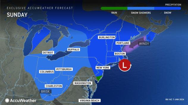
Snow quickly spread farther to the north over the Appalachians and the northern tier of the mid-Atlantic prior to expanding over much of New England Saturday night, where it will continue to fall through Sunday. Warm Atlantic Ocean waters, in the 40s F, will continue to play a huge role in the form of precipitation from New Jersey to Cape Cod, Massachusetts into Sunday, by preventing snow or limiting the amount of snow.
As AccuWeather meteorologists predicted, little to no snow fell along a line that roughly followed Interstate 95 from Washington, D.C., to Baltimore, while a wintry mix occurred for a time in Philadelphia and central New Jersey.
Just to the north and west of I-95 in this swath, several inches of snow and a wintry mix occurred, along with a reality check that the calendar has recently flipped to a new year and new month.
Across the New York City metropolitan area, snow began falling Saturday afternoon before changing over to mainly rain late Saturday evening. A few rain or snow showers will last into Sunday morning before tapering off to just a few flurries by the afternoon.
However, only a few miles north and northwest of the New York Metro area, colder air is likely to continue holding its ground and lead to a much heavier snowfall that will ramp up to 6-12 inches and locally higher amounts in portions of southeastern New York, western Connecticut and northern New Jersey.
 |
This will end up as a major snowstorm from northeastern Pennsylvania to central New England, including the Boston area, where 4-8 inches of is likely to accumulate around the harbor and heavier amounts near and west of I-95 through Sunday.
Among the cities likely to pick up 6-10 inches of snow from the storm spanning through Sunday include Scranton, Pennsylvania; Albany, New York; Hartford, Connecticut; Rutland, Vermont; and Manchester, New Hampshire.
A broad zone of snowfall totals between 3-6 inches is extending from the borders of Virginia and West Virginia through much of central and southeastern Pennsylvania, much of New York, central Maine and just inland of the southern coast of New England.
Because of the quick movement of the storm, an excessive amount of snow that could rival some of the biggest snowstorms to hit the area is highly unlikely to occur. However, the AccuWeather Local StormMax™ snowfall for this is 24 inches, which is a formidable amount of snow for any winter storm.
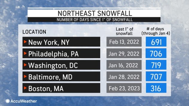
Still, enough snow is likely to fall to bring the biggest single storm in two years to many locations such as State College, Pennsylvania; Caldwell, New Jersey; Danbury, Connecticut; and Boston. The last storm to bring more than 4 inches to Boston/Logan International Airport was on Feb. 25, 2022, when 8.5 inches of snow fell.
 |
The same quick movement and last-minute strengthening of the storm will prevent long-duration winds. Any coastal flooding will tend to be minor and brief along the eastern coast of New England on Sunday. Brisk winds in the wake of the storm may lead to some minor blowing and drifting snow from late Sunday to Monday, where rain or ice did not mix in.
For those who were not able to travel ahead of the storm into Friday night, conditions will improve from west to east across the region on Sunday afternoon and Sunday night, provided highways are not clogged with stalled cars and accidents that occurred during the height of the storm from Saturday afternoon to Sunday morning.
The period between the weekend storm and the next storm on deck will be brief. By Tuesday, the next storm will begin to affect the central and southern Appalachians.
However, that next storm is projected to track toward the Great Lakes and become massive in size and significant in strength. Because of these conditions, a surge of warm air will result in rain as the primary form of precipitation in much of the Northeast. That rain will be accompanied by moist air and strong winds.
"The warm rain event next week will likely bring a rapid meltdown of the existing snow cover on the ground beneath that is still wet from prior storms in December," DeVore said. "In turn, flooding of urban areas, small streams and even along some of the major rivers is a strong possibility in the region." This flood threat can potentially pose a significant risk to lives and property.
 |
In addition to the likelihood of heavy rain and flooding is the risk of damaging winds and regional power outages in the Northeast from the intense storm over the Midwest from Tuesday to Wednesday.
Property owners and road crews may be able to help with flood control by keeping storm drains free from piles of snow during storm cleanup operations.
Want next-level safety, ad-free? Unlock advanced, hyperlocal severe weather alerts when you subscribe to Premium+ on the AccuWeather app. AccuWeather Alerts™ are prompted by our expert meteorologists who monitor and analyze dangerous weather risks 24/7 to keep you and your family safer.
