Quick-moving storms to bring more snow to Midwest, Northeast this week

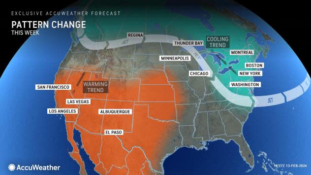
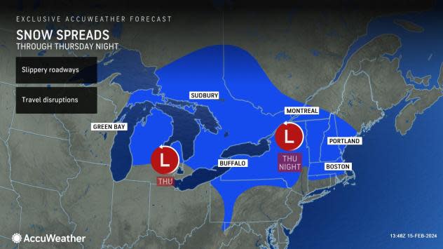
A storm that dumped a foot or more of snow in parts of the Northeast Tuesday will mark a change to a weather pattern more typical of mid-February for the Northeast and much of the Midwest. An Alberta clipper will bring a small accumulation of snow to some areas missed by the East Coast storm from into Thursday evening, AccuWeather meteorologists advise.
The colder pattern will allow many to enjoy some time on the ski slopes, as areas that have not picked up fresh, natural powder will be able to make snow during the coming nights. For others more sensitive to the cold or who may have gotten used to the balmy conditions of late, the pattern will be an uncomfortable change.
 |
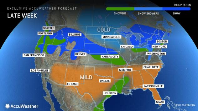
A dip in the jet stream will bring temperatures more typical of February's second and third weeks. For example, in New York City, historical average temperatures range from a low near 30 F to a high in the low 40s. Into Friday, low temperatures will range from the low to mid-30s, with highs from the upper 30s to the mid-40s.
Farther to the west, in Chicago and Detroit, historical average temperatures range from a low in the lower 20s to a high in the mid-30s. Forecast temperatures into Thursday will be a bit above the historical average but significantly lower than a few days ago. By Friday, more of a downturn is in store, with highs in the 30s and lows in the mid-10s to lower 20s.
 |
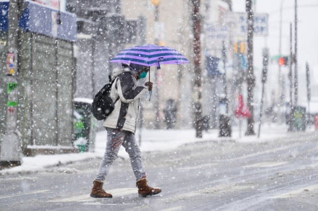
The snowfall in the Northeast will raise the risk of potentially dangerous freeze-ups.
In areas where natural melting occurs during the day, wet and slushy areas will freeze at night and may create thin sheets of ice. Motorists and pedestrians should use caution when traveling in areas that appear to be wet, as some surfaces may be icy. Many slip-and-fall incidents occur days after a snowstorm, according to forensics experts. The conditions may persist throughout the week, including areas where snow has been shoveled or plowed.
 |
A pedestrian crosses a street during a winter snowstorm in Philadelphia, Tuesday, Feb. 13, 2024. (AP Photo/Matt Rourke) |
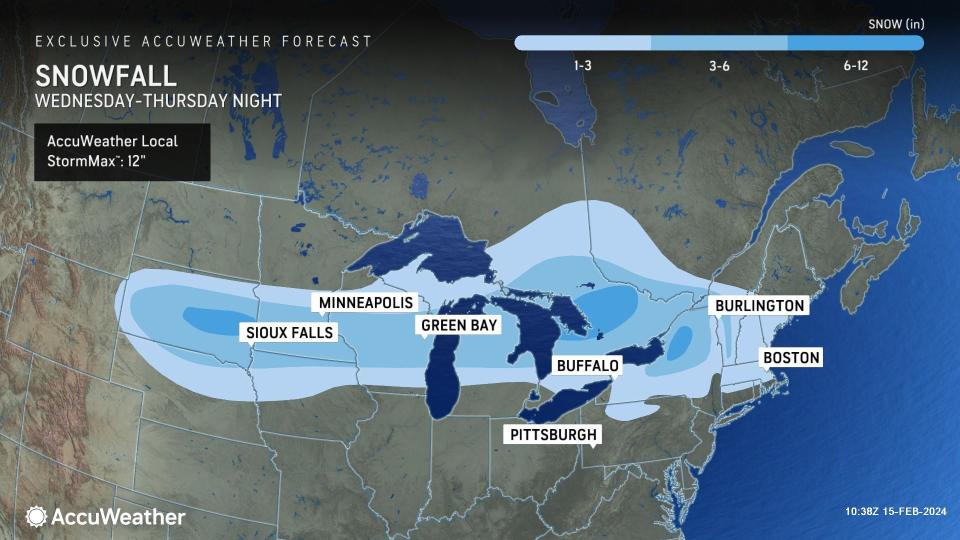
Accompanying the more typical temperature pattern will be at least one storm with snow that travels along the northern tier of the United States into Thursday evening. This storm produced widely separated snow showers in Montana and Idaho Tuesday morning. As the system streaks eastward, it will gather some moisture from the Gulf of Mexico and, to some extent, the open waters of the Great Lakes.
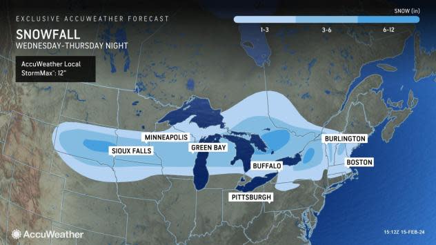
The clipper storm brought a general 1-7 inches of snow from South Dakota to central and southern Minnesota, Wisconsin and in western parts of Michigan from late Wednesday to Thursday morning. From 1 to 3 inches fell in southern Wisconsin, including the Milwaukee and Madison metro areas. A maximum of about 8 inches fell on Huron, South Dakota. Just rain fell on Chicago.
 |
From 5 to 7 inches of snow fell on the Minneapolis metro area from the storm. This has been the biggest storm of the season and the first time in many months that the Twin Cities have seen an inch or more of fresh powder. The last time there was an inch of snow or greater on a single calendar day was back on Halloween. Before this storm, only 7.3 inches of snow had fallen on the city thus far this winter; much of that has been a few tenths of an inch at a time. The historical average for snow through Feb. 13 is about 39 inches. The storm has boosted the seasonal total to 14.2 inches as of the start of Feb. 15.
Farther to the east, 1-2 inches of snow fell on Detroit during the midday hours as heavier snow fell on central Michigan.
In the Northeast, no accumulating snow is anticipated from Washington, D.C., to Philadelphia and New York City during Thursday night, but those in northern Pennsylvania, upstate New York and central and northern New England may have snow showers frequent enough to bring 1-3 inches with locally higher amounts. Any snow showers around New York City Thursday night will not amount to much. Parts of northern New York state may pick up a 6- to 12-inch snowfall with up to half a foot of snow on the mountains of Vermont and New Hampshire.
 |
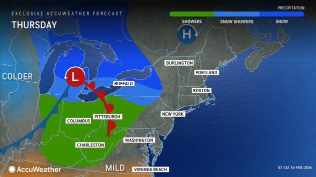
A second storm will reach the Central and Eastern states 24 to 36 hours later, but this storm is forecast to take a path farther to the south over the Plains, Midwest and mid-Atlantic.
Snowy and slippery travel may spread eastward for nearly 2,000 miles from the Rockies Thursday night to the mid-Atlantic coast by Saturday morning. The strip of snow farther south from the second storm is likely to slow travel in metro areas such as St. Louis, Cincinnati and Washington, D.C. It's likely that snow from the second storm will pass to the south of Chicago and Detroit but could swing northward enough at the last minute to graze New York City.
 |
The air associated with and behind that second cross-country storm this weekend will be several degrees colder than conditions during much of this week.
Want next-level safety, ad-free? Unlock advanced, hyperlocal severe weather alerts when you subscribe to Premium+ on the AccuWeather app. AccuWeather Alerts™ are prompted by our expert meteorologists who monitor and analyze dangerous weather risks 24/7 to keep you and your family safer.
