The Greater Toronto Area is on the cusp of a historic dry spell

We’re in the midst of a remarkable stretch of dry weather across parts of Ontario and Quebec, an arid spell that could rival years-old records before long.
This period of curiously serene conditions stands in contrast to the rocky and humid weather many communities endured through the first half of the summer.
OFFICIAL FALL FORECAST: A fickle fall: Strengthening El Niño triggers a two-faced season
An active summer comes to an abrupt end
This was a pretty active summer across Central Canada.
We didn’t see much heat across the region—in fact, many communities in southern Ontario not only went through August without hitting 30°C, but some also broke the record for the month's coolest high temperature ever measured.
What we lacked in heat, though, we made up for in humidity and plenty of thunderstorms to tap into all that tropical moisture locked over the region.
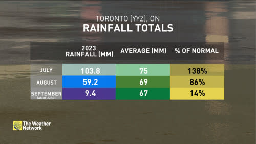
Toronto measured 103.8 mm of rain this past July, a sum that landed the month at nearly 140 per cent of its normal rain. These storms were brutal, too, flooding roads around Ottawa, dropping hail as large as baseballs, and spawning numerous tornadoes throughout the region.
DON’T MISS: Canada's summer defined by record wildfires, damaging floods and storms
Things started to change in August, when Toronto’s rainfall total came in slightly below average for the month.
But the bottom dropped out once September rolled around. Sunday, September 24, marked Toronto’s 12th consecutive day without measurable precipitation, making for the longest stretch of dry weather we’ve seen in the city so far in 2023.
And there’s no relief in sight.
WATCH: Canada’s summer was a season of records and astonishing sights
A dry pattern dominates into October
A persistent ridge of high pressure will make itself at home over much of Ontario and Quebec heading into the start of October.
Ridges are beloved by folks who love calm, clear weather this time of year. Air descends beneath a ridge, warming up and drying out as it sinks toward the ground.
The end result is usually a spell of relatively calm conditions with minimal precipitation. While this can lead to a brutal heatwave in the summer, the concept of ‘seasonal’ temperatures changes in a hurry during the fall. Above-seasonal this time of year is generally pleasant.
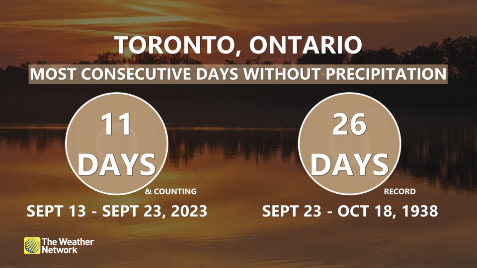
Toronto’s double-digit dry spell will likely continue for a while longer thanks to this persistent ridging—so long, in fact, that it’s worth talking about all-time dry records.
MUST SEE: How the Great Lakes influence fall and winter weather in Ontario
The city’s longest stretch without measurable precipitation in recent history happened in September 2017, when we saw 21 consecutive days without a drop of rainfall landing in the gauge.
Autumn also saw Toronto’s all-time longest period without measurable precipitation, which unfolded across 26 days between late September and mid-October back in 1938.
Over in Montreal, our longest period without measurable rain this year lasted for 12 days through the middle of May, and the city’s all-time longest dry spell lasted for 30 days between July and August 2001.
Stay with The Weather Network for all the latest on conditions across Ontario and Quebec.

