When will all this rain stop in South Florida? Where is Tropical Storm Eta going next?
Tropical Storm Eta is continuing to douse South Florida with heavy rain Monday, and it won’t be easing up anytime soon.
While the storm’s gusty tropical-storm-force winds might be over by late Monday, South Florida’s rain chances will remain high through the week despite Eta’s center already in the Gulf of Mexico, according to the National Weather Service.
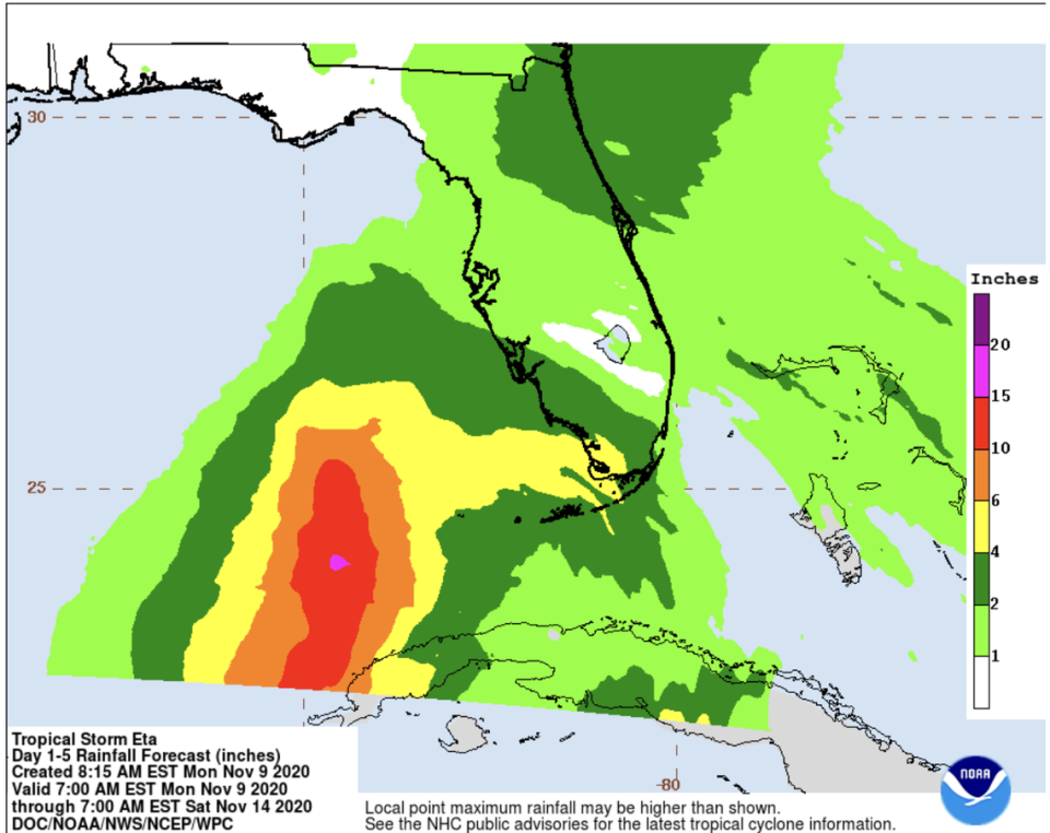
Monday night’s 80% chance of rain will slowly decrease to a 40% chance of rain by Thursday night. South Florida’s flood watch might also be extended because of the heavy rain forecast, the weather service said.
The rest of the state is also forecast to feel Eta’s heavy rains the rest of the week, with the storm expected to make a second landfall around the Big Bend of Florida by late Friday or early Saturday, according to the Weather Channel. However, forecasters warn that the track is still uncertain.
Here’s what to know:
Where is Eta going and how strong will it be?
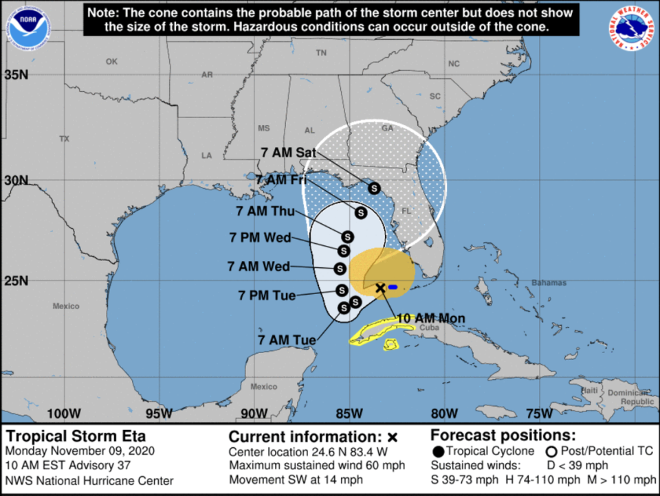
As of 10 a.m. Monday, Eta was moving west over the southeastern Gulf of Mexico at 14 mph and its maximum sustained winds have decreased to nearly 60 mph with higher gusts.
On the forecast track, the center of Eta is moving away Monday from the Florida Keys and South Florida and is no longer forecast to briefly strengthen into a Category 1 hurricane, according to the National Hurricane Center.
Forecasters say it’s possible that the trough that kept Eta’s center south, in the Keys, could also collapse in the next few days, leaving Eta hovering in one spot through nearly Wednesday, potentially dumping even more rain on Florida.
The forecast shows Tropical Storm Eta potentially making landfall in the Big Bend of Florida late Friday or early Saturday. Forecasters warn that they have low confidence in this track and say it could change at any time.
What type of weather will Eta bring to the rest of Florida?
Eta could approach the Florida Gulf Coast later this week as a tropical storm, bringing rain, wind and storm surge, although there is still uncertainty on the storm’s track and strength.
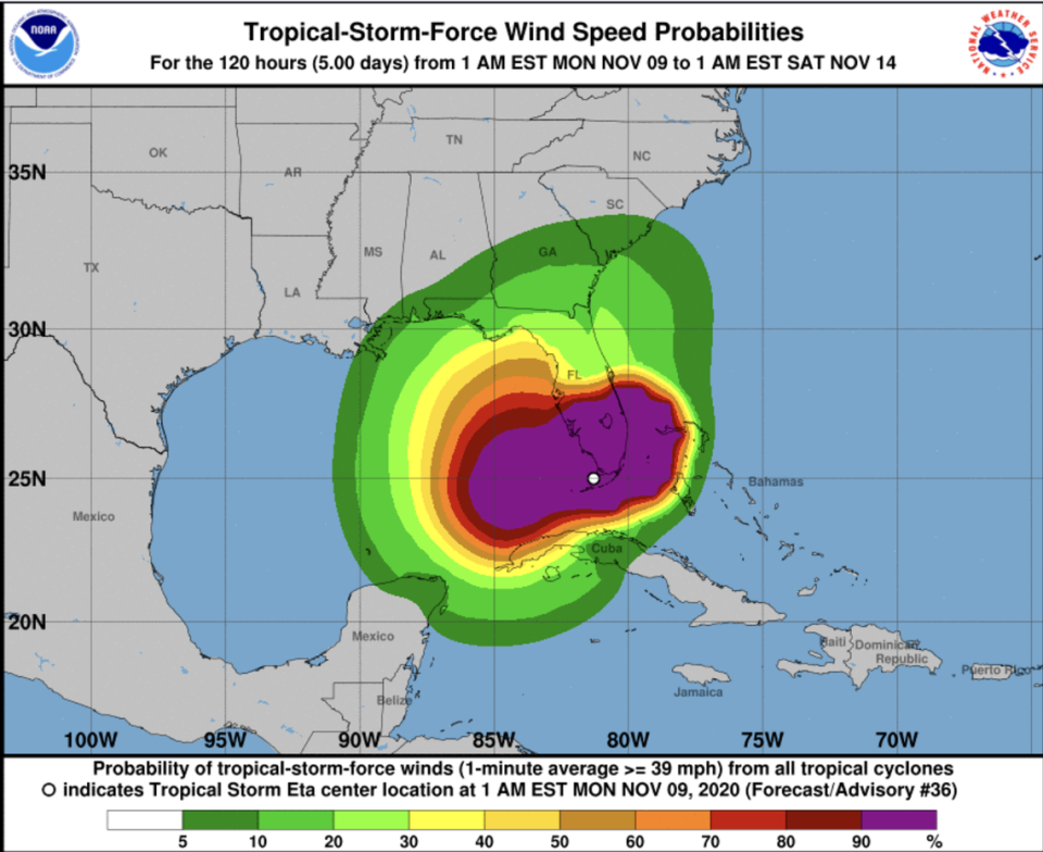
What forecasters do know is that most of Eta’s tropical storm force winds will be felt Monday from the Keys to Southwest Florida with Manatee, Sarasota and Hardee counties under a tropical storm warning.
“As the storm temporarily pulls away, the forecast area should see a break from tropical storm force winds Tuesday through most of Wednesday, although wind speeds will remain breezier than normal,” forecasters wrote. “The center of Eta will drift back north and then northeast late Tuesday through the rest of the week, with another period of tropical storm force winds possible for much of the coastline of west central and Southwest Florida.”
The highest threat of heavy rain and flooding also looks to be Monday, with a flood watch still in effect for Lee and Charlotte counties as rain continues to douse the Florida peninsula, the National Weather Service said.
Orlando, for example, will be seeing 90% chance of rain Monday, with the chances ranging from 40 to 70% chance of rain the rest of the week until Friday, when tropical storm conditions will be possible, according to the weather service.
“Even after Tropical Storm Eta pulls farther away from the area Tuesday and into midweek, conditions will remain hazardous at area beaches with rough surf and a high risk of life-threatening rip currents through much of the upcoming week. Boating conditions will also remain hazardous,” the National Weather Service in Melbourne said.
Bradenton, meanwhile, is forecast to see tropical storm conditions through Tuesday night and will then have a 20 to 40% chance of breezy showers until Wednesday night. That’s when tropical storm force conditions are expected to begin again through at least Thursday night.
Tampa has a 60% chance of rain Monday, with the rain chances dropping to 20-40% through Wednesday night before picking up again. Tropical storm conditions are forecast for Friday.
To get a better idea of how Eta might affect where you live, check your local weather forecast at www.weather.gov.
Tropical Storm Eta’s Watches/Warnings in Florida
The tropical storm warning has been discontinued for all of Florida and the Keys, excluding the Dry Tortugas, which still remain under a tropical storm warning, as of the hurricane center’s 10 a.m. advisory.
