Rains make curiosity rise whether Whiskeytown Lake's 260-foot-deep Glory Hole will be used
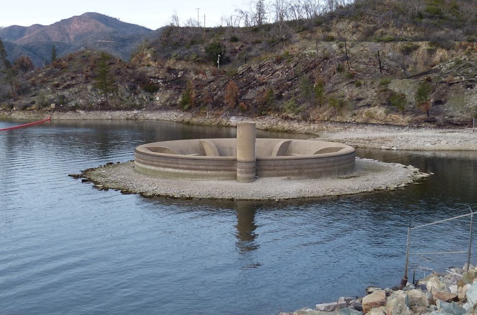
There's a 24-foot "hole" at the bottom of Whiskeytown Lake that extends through the lake's dam. Those who have ever visited the dam have likely seen the concrete hole sticking up from the surface of the lake.
Most of the time, the surface of the lake is above the entrance to the "Glory Hole," so water can't get in, but when the lake level rises too high, water pours into the giant pipe, keeping water from going over the dam. The 24-foot-diameter concrete pipe runs down to the bottom of the lake and then cuts at a sharp angle and out through the downstream side of the dam.
Once every few years, during periods of heavy rain, the lake level rises so high, creeping closer to the crest of the dam, that water flows over the top of the Glory Hole and cascades down into the giant gullet.
Visitors who stop to gaze at the water sheen as it spills over the rim describe it as "soothing," "cool" or "creeped me out."
"Yeah, it's exciting when it happens. It's pretty cool to watch. It's like a big whirlpool," said Josh Hoines, superintendent of Whiskeytown National Recreation Area, which encompasses the lake.
Water flowed into the Glory Hole twice in 2022, Hoines said. Before that, it had not overflowed since 2019.
How the Glory Hole at Whiskeytown Lake works
When the Glory Hole does overflow, visitors often stop to snap photos from the small parking lot near the bas-relief panels at the John F. Kennedy Memorial that marks the date on Sept. 28, 1963, when the former president visited the area to dedicate the new dam and lake.
The Glory Hole is one of four outlets from the lake, said Don Bader, area manager for the U.S. Bureau of Reclamation, which operates the Whiskeytown Dam.
There are two lower outlets beneath the surface of the lake and under the dam. The top of the Glory Hole sits at 1,210 feet above sea level. The upper outlet is 100 feet below the Glory Hole, and the lower outlet is another 135 feet down, which allows bureau officials to let colder water out of the lake to benefit fish that live in Clear Creek below the dam and in the Sacramento River, Bader said.
Another outlet flows under the visitor center near Highway 299, through large pipes through the hills northwest of Redding. The pipes carry the water to the Spring Creek Powerhouse and then into Keswick Reservoir.
When rainfall is so heavy that releases from those various outlets is unable to keep up with the amount of rain flowing into the lake, the surface level rises high enough to overtop the Glory Hole, preventing the lake from going over the top of the dam.
Lake Shasta level rising, with more rain on the way. How close is it to being full?
What happens if water spills over (drops into?) the Glory Hole vortex?
When the Glory Hole does spill, word gets out fast through the internet and social media, drawing visitors from around the region and state to see water sucked from the surface of the lake into a giant black hole.
Rainfall in the area of Whiskeytown Lake is nearly double the amount in the Redding area, Hoines said. The lake receives an average of about 60 inches of rain a year, compared to about 32 inches at the Redding Regional Airport.
The Glory Hole features a dizzying 260-foot drop from the lip to the bottom and has no safety devices to prevent fatal falls. At the bottom, the vertical tunnel makes a sharp turn toward the dam. Despite the gaping hole at the top, Bader and Hoines said no one has ever fallen into the massive structure.
Bader said objects, such debris and driftwood, don't usually wash into the drain. But crews are sent down into the enormous hole from time to time to inspect the concrete and make sure it remains sound, he said.
Tragedy at the Glory Hole in Napa County's Lake Berryessa
Whiskeytown is not the only lake in California with a glory hole.
Lake Berryessa in Napa County has a 72-foot-wide glory hole that prevents water from spilling over the lake's Monticello Dam.
There was an incident in 1997 when a woman reportedly plunged to her death after she fell over the rim of that glory hole, according to the San Francisco Chronicle.
Remember this about Whiskeytown Lake's Glory Hole
Water goes down the lake's drop inlet, or Glory Hole, when the lake level reaches the 1,211-foot elevation.
The tunnel drops 260 feet down below the surface of the lake. Signs in the area warn visitors to stay away.
In the past six years, water dropped into the spillway on Feb. 21, 2017, Feb. 24-27, 2019 and Jan. 9-10, 2023.
The inlet is called the Glory Hole because the opening resembles the trumpet-shaped morning glory flower.
Reporter Damon Arthur welcomes story tips at 530-338-8834, by email at damon.arthur@redding.com and on X, formerly known as Twitter, at @damonarthur_RS. Help local journalism thrive by subscribing today!
This article originally appeared on Redding Record Searchlight: What is the Glory Hole at Whiskeytown Lake? What does it do?

