Rainstorm, mild air to close out 2018 and begin 2019 in northeastern US
2018 will end and 2019 will begin with a rainstorm and a surge of mild air over much of the northeastern United States.
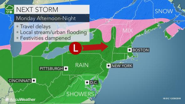
A lack of arctic air in the Northeast is forecast to set the stage for the next storm to bring all or mostly rain to the region, which has been the case for the last several storms.
Only a few of the colder nooks and crannies from central Pennsylvania to New England have the potential for a period of snow or significant ice at the onset. However, only in some of the northern tier locations might enough snow and ice occur to snap tree limbs and cause sporadic power outages.
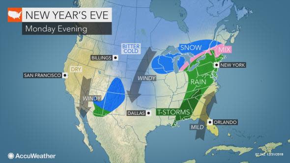
The remainder of the cold and snow will be across the Great Lakes and Northern Plains.
Rain erupted over the Ohio Valley during Sunday night and spread into part of the central Appalachians during Monday morning.
As the storm tracks northeastward, expect rain to spread into the mid-Atlantic Monday afternoon and then New England Monday night.
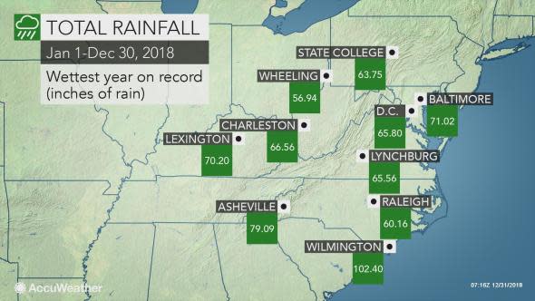
Pittsburgh may join nearly a dozen other major cities in the eastern United States that have already set a record amount of rainfall for the year.
If Pittsburgh receives 0.36 of an inch of rain from this storm by the end of Monday evening, it will have surpassed the current record of 57.43 inches of rain in one year set in 2004.
The heaviest rain is likely to fall on New England and from the central Appalachians to the central Gulf coast with this storm. These areas may experience urban and small stream flooding.
However, enough rain will fall to soak those who will be waiting outside for hours at Times Square in New York City. The heaviest rain may have departed Times Square around midnight, but is likely to fall on Boston from midnight to 6 a.m. on Tuesday.
Strong winds will accompany and follow the rainfall across the Northeast, and gusts can be high enough to cause localized damage. When the soil is saturated, trees and power lines can be downed by even a moderate wind gust.
In addition to rain and wind, fog may be a problem for those on the road and catching a flight.
Download the free AccuWeather app to see what the weather will be like for your New Year's Eve celebration or travel plans.
Very little rain may fall from central Virginia and southeastern Maryland on south with this storm. It may only rain a few hours in the swath from Philadelphia to Baltimore and Washington, D.C.
During the middle of the night into the early morning hours on Tuesday, the rain and spotty snow and ice on its northern end will overspread the balance of New England.
Since the storm is forecast to track west of the central Appalachians and across northern New England, warmer air will be pulled northward.
In such a setup, the warm surge on the storm's southern and eastern flank may not conform to the time of day.
Temperatures are likely to rise at night into Tuesday morning so that high temperatures for Monday may occur close to midnight and high temperatures on Tuesday may occur prior to noon in some cases.
In many cases, AccuWeather RealFeel® Temperatures may be 30-50 degrees Fahrenheit higher than last year, when frigid conditions prevailed.
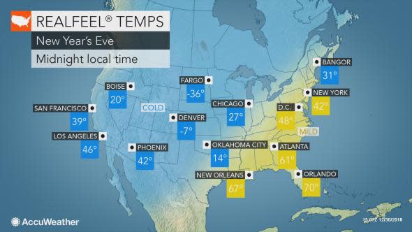
Instead of RealFeel Temperatures below zero, in the single digits and teens, it should feel like the 30s, 40s and 50s in many locations in the east around midnight on New Year's Eve.
Since this storm is forecast to be a fast mover, drier air will begin to settle in on New Year's Day. Conditions should be free of rain for the Mummers Parade and neighborhood gatherings in Philadelphia on Tuesday.
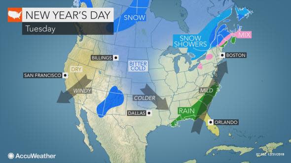
Expect colder air to filter in from the central Appalachians to the Great Lakes region, where it may be cold enough for snow showers by Tuesday evening in some locations.
Temperatures are likely to level off and fall in the dry air during the afternoon over much of New England and the coastal mid-Atlantic.
2018 was a record-breaking year for extreme weather events and storms. Extreme Meteorologist and Storm Chaser Reed Timmer talked to us about his top 5 chases of the year. He discussed some of his most dangerous experiences, what it's like to be out in the field and the moments he'll never forget!
