'Rapid intensification': How Idalia could quickly become a major hurricane before landfall
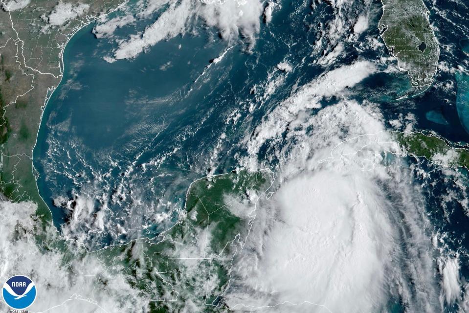
Idalia is forecast to strengthen rapidly as it moves north into the Gulf of Mexico and closes in on the west coast of Florida, and will likely be a major, Category 3 hurricane as it makes landfall, forecasters said Monday.
"Idalia is poised to rapidly intensify today-tomorrow, meaning it can go from a tropical storm to a very dangerous hurricane within the next couple of days," said Brian McNoldy, a senior research associate at the Rosenstiel School of Marine, Atmospheric and Earth Science at the University of Miami, in a Monday morning post on X, the site formerly known as Twitter.
"Plan to have preparations completed by the time tropical storm conditions arrive, and plan to evacuate if told to," he said.
What is rapid intensification?
Rapid intensification is a process in which a storm undergoes accelerated growth: The phenomenon is typically defined to be a tropical cyclone (whether a tropical storm or hurricane) intensifying by at least 35 mph in a 24-hour period.
"Rapid intensification occurs when a tropical storm or hurricane encounters an extremely conducive environment," Colorado State University hurricane researcher Phil Klotzbach said last year. "Typically, this environment consists of very warm water, low vertical wind shear and high levels of midlevel moisture."
Such sudden spikes have been the hallmark of history’s most fearsome hurricanes, Ken Graham, former director of the National Hurricane Center and now director of the National Weather Service, told USA TODAY.
In fact, out of the 10 hurricanes with winds of 150 mph or greater that struck the U.S. mainland over 104 years, all but one saw the explosion of force and power known as rapid intensification.
Hurricane Ian had two such bursts of wind last September, reaching winds of 155 mph briefly before it made landfall on Florida's southwest coast.
What does the National Hurricane Center say about Idalia?
In its 11 a.m. forecast discussion for Idalia, the National Hurricane Center said, "steady to rapid intensification is predicted beginning Tuesday while Idalia traverses the warm waters of the eastern Gulf and the upper-level environment becomes more favorable.
"The NHC intensity forecast again calls for Idalia to reach major hurricane strength before landfall along the Gulf coast of Florida," the hurricane center said.
'Be vigilant': Idalia intensifying, could slam Florida as major hurricane
'Ample fuel' for rapid intensification
The very warm waters of the northwest Caribbean (sea-surface temperatures around 86 degrees Fahrenheit) will provide ample fuel for the storm, said meteorologists Robert Henson and Jeff Masters on the Yale Climate Connections blog. "These warm waters extend to great depths, providing high oceanic heat content and reducing the chance that Idalia’s slow movement will cause major upwelling of cooler water. The eastern Gulf of Mexico is even warmer, with widespread sea surface temperatures of 88°F extending to well below 100 feet."
"These record-warm conditions will be exceptionally dangerous 'rocket fuel.'"' assuming that Idalia reaches the "eastern Gulf as a well-organized system," they said.
"We should not be surprised if Idalia makes landfall as a powerful, rapidly intensifying hurricane," Henson and Masters said.
See the spaghetti models:
"Spaghetti model" illustrations comprise a broad array of forecast tools and models, and not all are created equal. The hurricane center uses the top four or five ensemble models available to help make its forecasts.
Climate change may play a role
What role does climate change play in rapidly intensifying storms? "We have been seeing more and more explosive intensification over the past 5-to-10 years, and this certainly must be making everyone nervous," Jim Kossin, a hurricane expert at the University of Wisconsin-Madison and the nonprofit First Street Foundation, told Axios.
"These recent rapid intensification events have also been recently linked to climate change, which tends to create new normals that forecasters may struggle to get comfortable with." he said.
Masters, a former hurricane hunter meteorologist at the National Oceanic and Atmospheric Administration and founder of the Weather Underground, told USA TODAY that global warming is having consequences: "Climate change is causing more rapid intensification of Atlantic hurricanes," he said.
More: Tropical Storm Idalia tracker: Follow the storm’s path as it heads toward Florida
This article originally appeared on USA TODAY: What is rapid intensification? How Idalia will quickly gain strength.

