Brevard braces for more unusual weather after rare hail in Melbourne and Palm Bay
UPDATE: Much of eastern Florida - including Brevard County - has been placed under a severe thunderstorm watch until 10 p.m. Thursday, according to the National Weather Service in Melbourne. A thunderstorm watch means conditions are favorable for storms to form and produce heavy rain, hail, lightning and strong wind gusts.
For latest updates, go here.
5:54 p.m.: A strong line of thunderstorms was moving toward the area off Titusville, Playalinda Beach, and the Merritt Island Wildlife Refuge with the potential capability of producing waterspouts. The National Weather Service issued a special marine warning for the Volusia-Brevard county lines. Boaters were advised to move to safe harbor.
6:11 p.m.: A severe thunderstorm warning has been issued for west Central Brevard, meaning storms along with hail, heavy rains and strong wind gusts are moving toward the Space Coast. Residents are urged to use precautions and to monitor weather conditions.
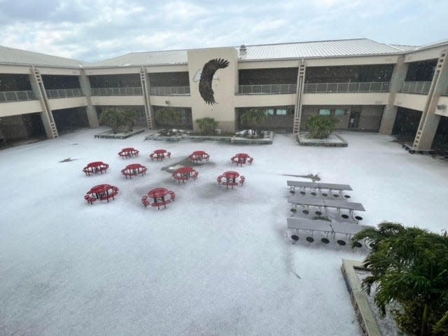
A rare hailstorm left portions of West Melbourne and Palm Bay looking like a Winter Wonderland on Wednesday, stunning residents and motorists, and weather officials are warning the same severe weather – with hailstones – could happen again over the next several days.
The rough weather dumped several inches of hail in front yards, school campuses and in the street, leaving behind a partially collapsed roof at a West Melbourne furniture store and a flipped over RV in Grant-Valkaria, injuring a man and child.
It was also the first major hail storm of its kind to take place in recent memory, weather officials pointed out. The scene looked like something you'd seen in the north — not typically in Florida.
“It was very unusual,” Kole Fehling, a meteorologist with the National Weather Service reported Thursday.
Rare storm: Hail hits West Melbourne, strong storms roll through Brevard County
'Insane' Florida weather: Best tweets, Instagrams, video, photos of hail in late April
'Freak' hailstorm left winter-like scenes in West Melbourne, Palm Bay
Fehling pointed out that the unusual weather happened after heavy moisture embedded some 20,000 feet up hit colder than usual air hovering over the state.
The storms began brewing along the interior of the state and quickly developed into severe weather that rolled its way across Central Florida onto the Space Coast. Even as Cocoa Beach residents reported sunny weather, West Melbourne and Palm Bay residents were hit about 3:30 p.m. Wednesday with blinding winds accompanied by pea and golf ball-sized hail. There is a chance more severe weather packed with hail could hit Brevard again by late afternoon Thursday, Fehling said.
"Each day is different. But we have a severe threat of thunderstorms and the possibility of more hail on Thursday, Friday and also on Sunday," Fehling said.
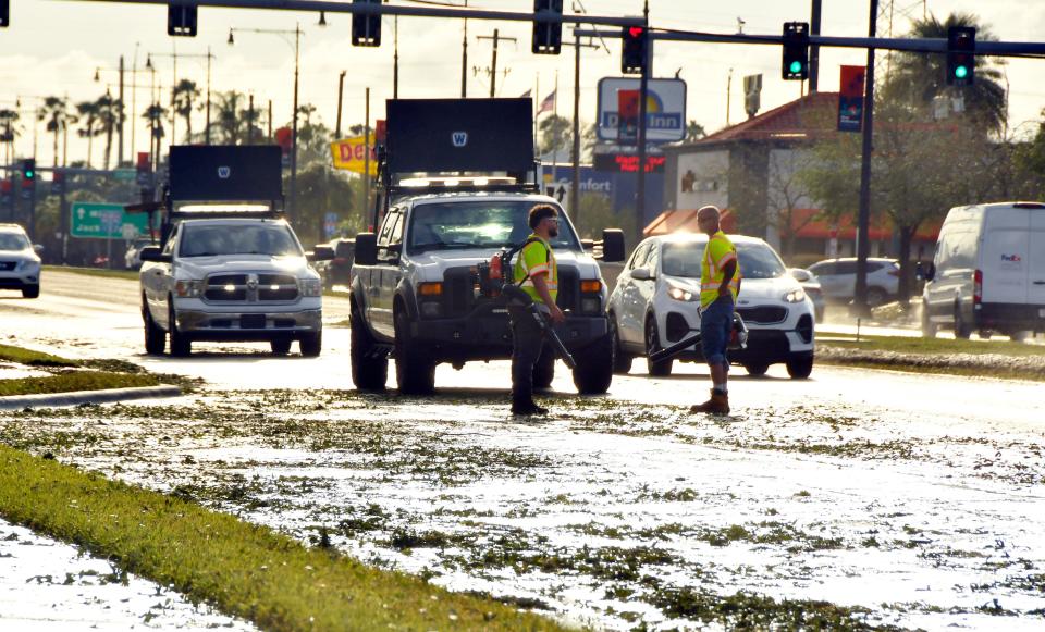
The hail was so powerful that it stripped some of the bark off of palm trees at the Interstate 95 overpass on West New Haven. Much of the hail draped parking lots and roadways, turning to frozen slush along West New Haven. The heavy rains also flooded out a portion of the eastbound lane of the roadway near Sam's and other west end stores in the area.
Jody Canada, a West Melbourne resident, was home in the Lynnwood gated community when the hail and wind began whipping through her neighborhood. The 29-year-old stood at the door and captured the hail as it pelted her lawn in a blinding white onslaught, piling up nearly a foot in some places.
"I wasn't sure what was happening," the West Melbourne native said. "It was thick. Even now all over the neighborhood, people have ice in their yards," said Canada, who said she scooped up some of the pea-sized hail and gave it a taste.
"It tasted like salt," she said, adding she could not remember another time where so much hail fell.
Besides the roadways and lawns, Central Middle School posted a photo showing the hail blanketing its campus in wintry white. School officials joked on their Facebook page, however, that there would be no 'snow days.'
Brevard has previously had six other hail events going back to 1950 involving hail that was at least 2-inches in diameter, the National Weather Service reported. The last major hailstorm happened March 27, 2019 when isolated showers spawned over Lake and Orange counties rolled toward Brevard, dumping quarter-sized hail in Cocoa, Rockledge and other parts of Central Brevard.
However, Wednesday's storm may have been the most intense and heaviest, residents and weather officials said.
J.D. Gallop is a criminal justice/breaking news reporter at FLORIDA TODAY. Contact Gallop at 321-917-4641 or jgallop@floridatoday.com. Twitter: @JDGallop.
This article originally appeared on Florida Today: Florida hail: Brevard could see more storms through weekend

