Reality check: Northeast faces snow, colder air following January thaw


- Oops!Something went wrong.Please try again later.
The caboose in a long train of storms responsible for rounds of rain and fog in much of the eastern half of the nation will finish on a cold enough note to spread accumulating snow from Ohio to Virginia and New England through Monday, AccuWeather meteorologists warn.
A pattern change featuring a return to colder air more typical of conditions for late January will slowly unfold early this week. A storm will roll northward along the East Coast during the middle of this transition to colder air, bringing the potential for wintry weather.
The storm will move northward only so far before turning to the east as colder air invades from the north and west.
Following an upward trend into the end of last week, temperatures will trend downward early this week, but Arctic air will remain absent.
For example, around Washington, D.C., following temperatures around 80 that established a new monthly record high on Friday, highs in the 40s, or just above the historical average, are forecast through Tuesday. After a high of 46 in New York City on Friday, temperatures will dip into the mid-30s for Monday morning, which is just cold enough to result in a mixture of rain and wet snow.
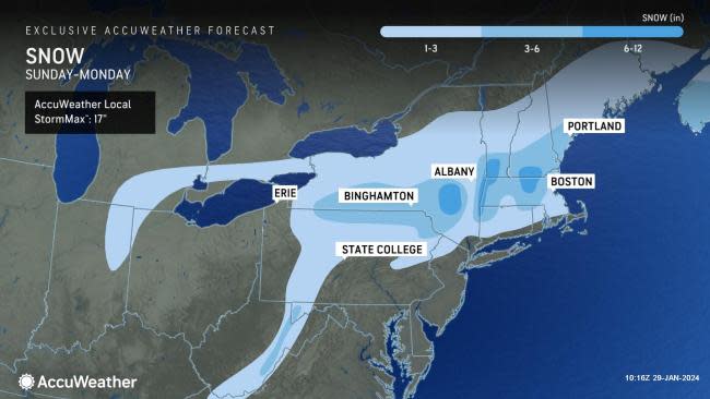
This track will allow snow to fall mostly near and north of Interstate 80 from the Appalachians into Pennsylvania and also across much of upstate New York and central New England. Within this swath, a general 1-6 inches of snow will fall outside of the Catskills and Berkshires, where 6-12 inches can occur. The AccuWeather Local StormMax™ for this event is 17 inches, which is most likely to occur in the higher terrain of the region.
Scranton, Pennsylvania; Albany, New York; Portsmouth, New Hampshire; Rutland, Vermont; Portland, Maine; and Boston are among the cities that could receive accumulating snow through Monday.
However, even in the Susquehanna Valley and areas from central New Jersey to Philadelphia, as well as southern New England and the Appalachians in western Maryland, West Virginia and western Virginia, a change to wet snowflakes can briefly occur before the storm pulls away Monday morning.
 |
The duration and intensity of that wet snow at the tail end of the storm will be the key to any accumulation, including along the I-95 corridor of the mid-Atlantic.
In most cases, this will be a wet, clinging snow, unlike the dry, powdery snow events that occurred in early to mid-January. Photographers may want to get their cameras ready as the lack of strong winds in the wake of the storm will result in photogenic wintry scenes across the region on Monday. However, breezy conditions in eastern New England may be enough to trigger some blowing and drifting snow.
Even if it does snow steadily for a few hours at the end of the storm through early Monday, warm road surfaces in the I-95 corridor will likely prevent the snow from accumulating on the major highways, AccuWeather Senior Meteorologist Bill Deger said.
"Enough snow may fall to bring a small accumulation on non-paved surfaces, especially to areas outside of the immediate New York City metro area," AccuWeather Radio Personality and Meteorologist Dean DeVore said.
A coating to an inch of snow may occur well to the north and west of the I-95 mid-Atlantic cities, mainly on grassy areas. Bridges, overpasses and some secondary roads may become slushy in lower elevations.
Motorists should expect slippery travel, especially over higher elevations such as through the Poconos, Alleghenies, Catskills and Berkshires, into early Monday. Aircraft parked overnight Sunday at the major or regional hubs may need to be de-iced before takeoff early Monday morning, which may spark significant airline delays.
 |
Foggy conditions may worsen to end the weekend in parts of the Ohio Valley and the East before they improve early this week. Looking ahead, this week's colder, more seasonable weather pattern will bring the potential for a couple of snow events in parts of the East.
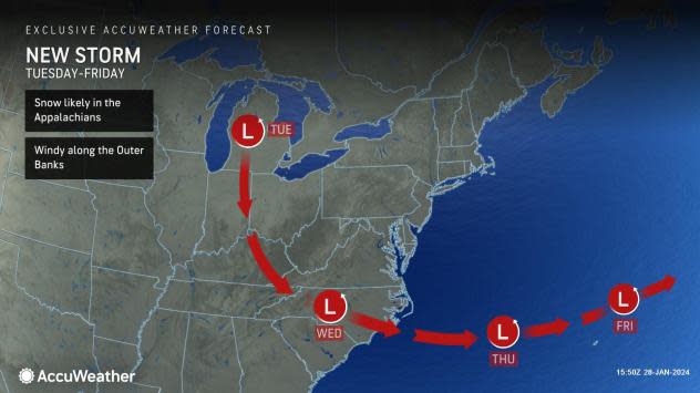
The first opportunity for snow this week will be from a clipper storm that drops southeastward from central Canada. The quick-moving storm will not have much moisture to work with, but it could bring a coating to an inch or two of snow to parts of the Midwest from Monday night to Tuesday and the southern Appalachians from Tuesday night to Wednesday.
Beyond midweek, the same storm could get new life as it moves over the Atlantic Ocean on Thursday.
 |
Should a buckle in the jet stream capture the storm in just the right way, the storm could make a left turn and head up the coast. In this scenario, moisture could be thrown back into the Northeastern states -- much of which may fall as snow from Friday to Saturday.
Want next-level safety, ad-free? Unlock advanced, hyperlocal severe weather alerts when you subscribe to Premium+ on the AccuWeather app. AccuWeather Alerts™ are prompted by our expert meteorologists who monitor and analyze dangerous weather risks 24/7 to keep you and your family safer.
