Record-breaking 2020 Atlantic hurricane season officially over ... but could still break more records


Generating storms at a rapid-fire pace and filled with enough plot twists to rival an M. Night Shyamalan movie, the 2020 Atlantic hurricane season started early and ended with a trio of storms in late October through mid-November. And, as AccuWeather Chief Broadcast Meteorologist Bernie Rayno remarked, "it never stopped" in between.
AccuWeather's team of tropical weather forecasters, led by veteran meteorologist Dan Kottlowski, saw many of the plot twists coming way back in March when they called for a "hyperactive" Atlantic basin season to ensue, and the 2020 hurricane season indeed provided steadfast suspense with what seemed like daily new tropical developments and all manner of unique storm tracks.
Along with giving multiple pages of the hurricane record book some new ink, the 2020 season also challenged conventional logic for some long-held assumptions about hurricane season, such as the pace at which a storm intensifies and the areas where certain storms may hit.
 |
Plus, the 2020 season also demonstrated how the official June 1 beginning and Nov. 30 end of hurricane season are flexible dates in the eyes of Mother Nature.
For just the second time in the modern hurricane-naming era, the Atlantic season exhausted its pre-determined list of designated storm names for the season. After burning through the 21 names from the English alphabet by mid-September, the season began moving through the Greek alphabet for the first time since 2005.
 |
A satellite loop showing Hurricane Laura's journey from the Caribbean Sea northward across the Gulf of Mexico and making landfall as a Category 4 storm along the Louisiana coast in late August. (NOAA / AccuWeather) |
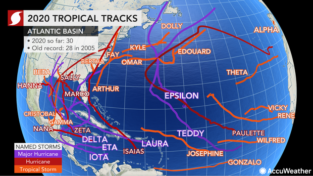
With 30 named storms this year, the 2020 season shattered the record previously held by the infamous 2005 season for most named systems in a single season. Of those 30, 13 became hurricanes and six of those became major hurricanes - Category 3 or stronger. And just because the Atlantic basin hurricane season ends on Nov. 30, that doesn't mean more tropical cyclone activity won't happen this year -- more on that below.
Like a well-rounded prizefighter, the season packed speed, strength and stamina into its six-month marathon. Here are some of the biggest takeaways that will be remembered when looking back on the 2020 season:
Right out of the gates, even before hurricane season was officially underway, a flurry of storms developed and broke many records in the process. The season's first named system, Tropical Storm Arthur, formed on May 14 and was quickly followed by Tropical Storm Bertha 10 days later. The pair of May storms marked the first Atlantic basin hurricane season since 2012 that featured two "pre-season" storms, as both formed before June 1, the official beginning of the Atlantic basin hurricane season.
 |
That quick pace set the tone for the season, in which dozens of records were broken. After Bertha, Tropical Storm Cristobal became the fastest forming C-letter storm on record, and while Tropical Storm Dolly didn't get the record for earliest-forming D-letter storm, every following storm from Tropical Storm Edouard to Hurricane Iota broke the respective earliest-forming records.
The speed of intensification was also remarkable with a number of the tropical cyclones this season. According to Sam Lillo, a meteorologist with the University of Oklahoma, 10 of the season's 13 hurricanes underwent rapid intensification, matching a record set by the 1995 season.
Rapid intensification is defined as a storm undergoing a maximum wind increase of at least 29 mph within a 24-hour period. Lillo added that six of those storms were Greek-letter storms.
One of those rapidly intensifying storms, Zeta, also packed notable forward speed during its trek across the Gulf of Mexico. Barreling toward Louisiana, the hurricane moved at a breakneck pace of 22 mph and quickly jumped from Category 1 to Category 2 strength just before coming ashore.
At the spot of landfall, AccuWeather National Reporter Jonathan Petramala captured the moments Zeta bolted onshore and tore homes apart.
In the eye. Watched this homes roof explode off in the inner eyewall of #HurricaneZeta Hwy 1 is a raging river south of the flood gate @breakingweather @accuweather pic.twitter.com/NnTGFJNPz3
— Jonathan Petramala (@jpetramala) October 28, 2020
Although the storms of 2020 will certainly be remembered for their quantity and rapid succession, the cumulative strength of the season, recognized by the Accumulated Cyclone Energy (ACE) Index, paints a different picture.
While this year's season packed the highest number of total named storms of any season on record, the ACE index suggests that the season may have been more mild than extreme.
CLICK HERE FOR THE FREE ACCUWEATHER APP
"The Accumulated Cyclone Energy Index characterizes the intensity and longevity of all storms in a year," AccuWeather Broadcast Meteorologist Geoff Cornish said. "While the Atlantic produced more storms than any other year on record, the ACE generated by the 30 storms was disproportionately low."
Cornish explained that as the season draws to a close, "2020 lands in 13th place for ACE generated in a year." Records on ACE have been kept going back to 1851. "In other words," Cornish noted, "12 other years produced more ACE in the Atlantic than the 2020 season."
For perspective, Cornish, citing data from Colorado State University, pointed to the years 1933, 2005, 1893 and 1926 as Atlantic basin hurricane seasons that ranked substantially higher on the ACE Index despite having fewer storms.
"This indicates there were several weak storms during the season," Dan Kottlowski, AccuWeather's chief hurricane expert, said, adding, "2005 had more intense hurricanes with five Category 5 hurricanes." Kottlowksi pointed out that 2020 produced only one Category 5 storm, Iota, the last hurricane of the season (so far).
 |
"For much of this year, the ACE generated per storm has been half of the long-term, historical average," Cornish pointed out. "In other words, we've had a swarm of weaker, short-lived storms. However, there have been a few great exceptions like Teddy [the year's top ACE producer with 27.8 units], Eta, Paulette, the storm that wouldn't go away, Delta, Epsilon, Laura and Iota." All of those storms produced 10 or more units of ACE.
While Teddy, a Category 4 hurricane in September, produced the highest ACE, history is more likely to remember the devastating landfalls of hurricanes such as Laura in Louisiana and the combo of Eta and Iota in Central America.
Laura struck the Bayou State with landfalling winds not seen since pre-Civil War America, causing about $25 to $30 billion of damage, according to AccuWeather estimates. Louisiana was further damaged by Hurricane Delta and Hurricane Zeta en route to a record-breaking season for the state.
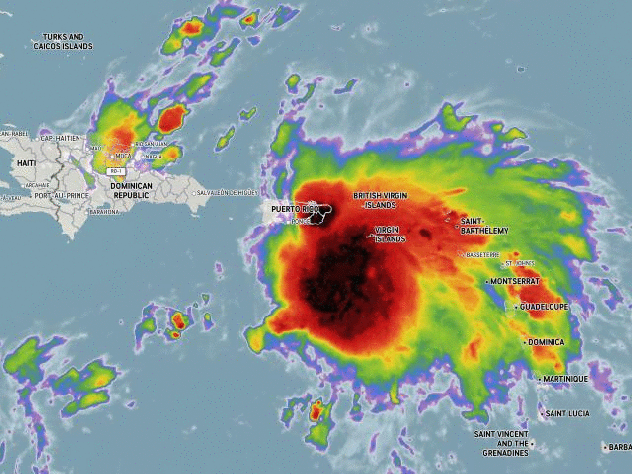
However, despite the cornucopia of previous storms, no 2020 storm packed as much punch as the final named storm of the season, Hurricane Iota.
Iota reached Category 5 strength on Nov. 16, becoming the first hurricane on record ever to reach that strength so late in a season. At its peak intensity, sustained winds hit 160 mph and the storm's central barometric pressure reached a minimum of 27.08 inches of mercury, or 917 millibars, as its center made a close pass by the Colombian islands of San Andrés, Providencia and Santa Catalina. Low barometric pressure is a telltale sign of a storm's powerful intensity.
Iota would go on to slam Central America in nearly the same exact spot that Hurricane Eta had wrought devastation less than two weeks before. Eta, which made landfall in Puerto Cabezas, Nicaragua, struck with Category 4 strength and claimed dozens of lives and left hundreds more missing.
Just two weeks later, Iota came ashore less than 15 miles from Puerto Cabezas and dealt another tragic blow to the region, triggering a humanitarian crisis with millions of residents being trapped in what AccuWeather Founder and CEO Dr. Joel N. Myers called "one of the worst floods in some of these areas in a thousand years or more."
Kottlowksi suggested that one reason that the 2020 season produced so many named storms could have something to do with meteorologists' enhanced ability to spot lesser tropical cyclones as technology has advanced over the years. He said that "newer technology enables forecasters to better analyze the smaller, less-detectable storms, and we had a few very short-lived storms, which might not have been detected more than 20 years ago."
"It started early - and it never stopped," AccuWeather Chief Broadcast Meteorologist Bernie Rayno said of the 2020 Atlantic basin hurricane season.
What the 2020 season may be most remembered for is just how long it lasted and its exhausting pace. "Typically, we get the mid-season doldrums in mid-July to mid-August," Rayno said. "That didn't happen this year."
In fact, the season never had a period of two consecutive weeks without at least one storm in circulation. The longest stretch without an active storm was between the end of Tropical Storm Cristobal and the start of Tropical Storm Dolly, which was 13 days.
It was common throughout the season to have multiple named storms occupying attention at once, particularly during September. At one point during the month, five different named storms - Paulette, Rene, Sally, Teddy and Vicky - were spinning at once.
The overabundance of storms also set a new record for the most landfalling named storms on U.S. soil in a single year -- 12 storms came ashore on the U.S. coastline, shattering the record of nine that had stood since 1916. Another record was set in Louisiana for most landfalling storms in the state for a single season.
The battered Bayou State sustained hits from five landfalling named storms this year, four of which were hurricanes. Spread out over 20 weeks, from Cristobal to Zeta, Louisiana residents never got a reprieve this season.
In terms of longevity, no 2020 storm lived longer than Paulette, which hung around for a whopping 15 days before dissipating near Portugal after impacting Bermuda a full week prior.
 |
A look at Paulette's long history in the Atlantic Ocean. (AccuWeather) |
Another notably long-lasting track was the one charted by Eta, which took a unique zig-zagging route from its initial landfalls as a hurricane in Central America, before making landfalls in Cuba and the Florida Keys as a tropical storm. Eta then made a final landfall along the west coast of Florida, near Tampa, a region that very rarely absorbs a direct hit from a tropical system.
 |
Hurricane Eta's winding journey featured significant impacts dealt to both Central America and the United States, with a stop in Cuba in between. (AccuWeather) |
In early August, Hurricane Isaias left a memorable mark on the season by ravaging the East Coast, particularly the Northeast. In Philadelphia and New York City, lives were claimed by the widespread flooding and falling trees as a result of the storm's intense winds and numerous tornadoes it spawned.
Widespread power outages also remained in the Northeast for multiple days, marking a wide-ranging spread of impacts after the storm's initial landfall in the Bahamas. The storm restrengthened into a hurricane in time to strike North Carolina following several days when it was parallel along the coasts of Florida and Georgia.
From there, Isaias pummeled the mid-Atlantic and Northeast, leaving long-lasting memories for a region not accustomed to such storms, a sentiment Kottlowski echoed when recounting his most memorable storms of the year.
"Isaias caused considerable wind damage up the East Coast of the U.S.," Kottlowski said. "I was impressed on how the storm maintained a very intense wind field for more than two days after moving inland."
While Nov. 30 may mark the official end to the Atlantic basin hurricane season, Mother Nature has always played by her own rules and 2020 could prove to be no different. Forecasters were closely monitoring a system that was beginning to take shape southeast of the Azores in the eastern Atlantic on Monday, warning that it could become Subtropical Storm Kappa at any moment. Subtropical storms are hybrid systems that acquire both tropical and non-tropical characteristics.
So should we have any confidence that the 2020 season will follow the rules and end before December?
"It is very unlikely that we'd see anything hitting the United States because the westerlies - the steering flow of winds out of the west - are so strong that any storm that would try to develop would likely be steered east of the U.S.," Rayno said of the potential for tropical activity beyond Nov. 30. But, he said, considering the entirety of the Atlantic basin, "I'm not going to rule it out."
As Kottlowski pointed out, some conditions are still in place to support development. "There is considerable warm water in place over parts of the Atlantic Basin that could support late-season development even during the month of December," he said. Indeed, during the waning days of the 2020 hurricane season, water temperatures were still above 80 degrees Fahrenheit in some parts of the Gulf of Mexico. And even in some places where temperatures were below 80, they were still above average for this time of year.
"I can see another storm [developing] that would take us to 31," Rayno said, noting that an eye should be kept on the area around Bermuda. But, he added, for the U.S., "I think essentially we're done."
Depending on where people live, the 2020 season could be remembered for a plethora of different reasons.
 |
This graphic shows all of the 30 named storms and their tracks during the 2020 Atlantic basin hurricane season. (AccuWeather) |
"The big story of this season is the number of landfalls and the rapid intensification of some of these storms," Rayno said. The two hot spots this season that really caught Rayno's attention were the areas of the Gulf of Mexico and the Yucatan Peninsula, which resulted in the Louisiana coast taking a beating as well as the Nicaragua coast, which Rayno dubbed "the Louisiana of Central America," being hard hit.
Kottlowski echoed that point. "Two major hurricane hits on Nicaragua and Honduras in nearly the same areas," he marveled. "Another highly unusual situation causing significant damage and suffering."
In Central America, the one-two punch of Eta and Iota could leave scars for decades, much like how the powerful effects of Hurricane Mitch from 1998 are still remembered.
In the Southeast, the barrage of Louisiana storms worked their way through inland areas and will leave plenty of dark memories following the widespread power outages that blanketed states such as Georgia.
However, for all weather enthusiasts, the memories of 2020 will be memorialized by the broken records and the nonstop twists and turns. Amid a wacky year that has left the globe upended by the coronavirus pandemic, an unprecedented and never-ending hurricane season may have been perfectly fitting. Or for some, maybe too fitting.
Keep checking back on AccuWeather.com and stay tuned to the AccuWeather Network on DirecTV, Frontier and Verizon Fios.
