Record highs forecast Tuesday for Green Bay, lack of rain make for high wildfire danger this week
GREEN BAY - Green Bay will be getting a little bit of everything this week with record high temperatures, snow and rain in the forecast as well as a high fire danger risk.
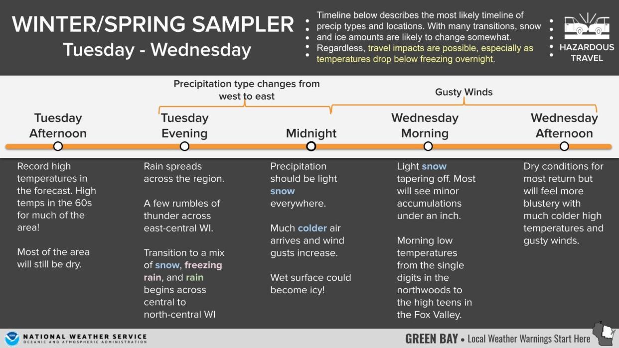
It'll be a busy weather week in the area this week. Monday afternoon, temperatures will be in the mid-50s. The warmth is expected to reach a record high Tuesday in Green Bay at 65, though "there's some potential for even higher" temperatures, said Roy Eckberg, a meteorologist at the National Weather Service Green Bay.
The current record high for Feb. 27 in Green Bay is 59 in 1896. The monthly record for the all-time high in February for northeastern Wisconsin may also be broken this week if temperatures get high enough Tuesday. The current record for the month is 65, set on Feb. 22, 2017.
Because of the rise in temperature, there is a high fire danger this week statewide, the state Department of Natural Resources cautioned.
Wildfire season is starting earlier this year because of the lack of snow cover and rain, the DNR said. In the past weekend, the DNR responded to 15 wildfires burning nearly 30 acres across the state.
In 2024 so far, the DNR responded to over 50 fires burning 160 acres, which have mostly been related to debris burning. The 10-year average is three wildfires burning two acres.
People should avoid all outdoor burning, including limiting starting campfires and bonfires, the DNR said. Be sure to discard hot ashes from wood stoves or fireplaces in a metal container until cold. Outdoor enthusiasts should also use caution with off-road vehicles or equipment that can create a spark and start a fire.
[2/25/24] 4:50pm
🌧️Record high temps possible Tuesday before tanking again Tuesday night, introducing chances for flash freezes in areas. Chances for rain and thunder are then possible Tuesday afternoon before transitioning to a wintry mix then mostly snow on Wednesday.#wiwx pic.twitter.com/0jkQWTUXFT— NWS Green Bay (@NWSGreenBay) February 25, 2024
Winter returns, briefly
The temperatures and rain will start to fall Tuesday evening when a cold front comes through the area. There will be a wintry mix of freezing rain, rain, and light snow overnight. Much of the accumulation will be under an inch in northeastern Wisconsin.
By Wednesday morning, there will be drop in the temperature down to around 18 in the Green Bay and Fox Valley area, Eckberg said. Wind chills are expected to go down to zero Wednesday morning.
"The cold's pretty much a one-day event," Eckberg said.
After Wednesday, things will warm back up for the remainder of the week with temperatures in the 40s Thursday and Friday.
This article originally appeared on Green Bay Press-Gazette: Record highs in Green Bay Tuesday make high wildfire danger this week

