Record Tuesday warmth threatens severe thunderstorms
Sharply colder air follows with snow showers; unseasonable warmth back this weekend


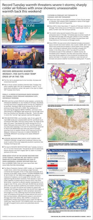
WGN WEATHER HEADLINES

RECORD BREAKING WARMTH Monday—THE DAY’S HIGH TEMP ENDS UP IN THE 70s
The fire risk is elevated due to low humidity, dryness and record-level warmth
Also in focus: severe weather potential later Tuesday into early Tuesday night—the risk is assessed a “level 2” on 5 level storm prediction center risk scale in the 4pm to 10pm CST Tuesday time frame
FINALLY—A PERIOD OF BACKWASH SNOW SHOWERS ARE POSSIBLE FROM PREDAWN WEDNESDAY INTO WEDNESDAY MORNING
2024 and the current 2023-24 winter season, currently the CHICAGO’S WARMEST IN 153 YEARS OF OFFICIAL RECORDS running more than 6 degrees above normal (6.3 degrees to be precise). Monday’s high temp eclipses the 24 year old previous record of 64 set in 2000. The reading is an eye-catching 28 degrees ABOVE NORMAL—and even more astounding is a 68-degree high equals the normal high more than two months from Monday on May 8th. That’s the date in which the “normal’ high typically reaches 68 degrees.
FIRE WEATHER RISK: Low humidity, lack of rain, gusty 30 mph SSW winds and unseasonable warmth contribute to an ELEVATED FIRE RISK. February precip ranks 7th driest of the past 153 years. That places the month among the 5% of driest Februarys here since 1871. Fire—and the spread of any fires which develop in this sort of environment—have led to RED-FLAG WARNINGS over area just west of Chicago covering much of western Illinois, all of Iowa and much of Missouri. Portions of Iowa are in a state of SEVERE TO EXTREME DROUGHT according to the latest DROUGHT MONITOR.
A SEVERE WEATHER RISK EXISTS LATER TUESDAY AND TUESDAY EVENING, though some scattered t-storms may erupt in parts of the area (especially southern sections) into Tuesday morning as well.
The level of SEVERE WEATHER RISK later Tuesday comes in at a “2” on the 5-level scale. The period at risk for potentially severe storms runs from roughly 4pm to 10pm in at least portions of the area.
SOME GEEKY STUFF ON THE SEVERE WEATHER RISK LATER TUESDAY, FORGIVE ME—BUT HERE’S A QUICK SAMPLING OF SOME PARAMETERS WE LOOK AT WHEN ASSESSING A SEVERE WEATHER RISK (feel free to IGNORE THIS if this isn’t your cup of tea—but some folks find this interesting):
The Storm Prediction Center’s HREF model—an “ensemble” model which, rather than providing a single forecast, combines the forecasts of the 2 most recent forecasts off 5 versions of the WRF model, places T-STORM PROBABILITIES AT 40 TO 60% OF THE AREA and suggests dew points, a measure of moisture, are to surge to the mid 50s—even approaching 60 southern sections. That assures a “juicy” air mass capable of sustaining any t-storms which may flare. Wind shear, important to severe weather development, is to surge to near 40 kts. and a 155-mph 35,000-foot jet stream wind max over southern California and western Arizona early Monday, is to race into Illinois and Indiana air space late Tuesday with Chicago sitting under the the left front region of a wind max. That’s a region in which jet-stream dynamics encourage air to rise, fostering cloud and precip development. All evidence at this point is these storms will occur in fast moving clusters, affecting some areas in and around Chicago more than others. Also, CAPES—a measure of atmospheric energy and buoyancy are to reach as high as 1500 j/kg. That’s not OFF THE CHARTS HIGH—but more than enough to support some active and potentially severe storms.
T-STORMS IN FEBRUARY NOT FREQUENT IN CHICAGO—NOR ARE TORNADOES
There have been no recorded tornadoes in Cook County proper in February. But twisters HAVE happened in parts of the larger CHICAGO AREA—just not frequently.
Since 1871, there have been 77 reports of February t-storms in Chicago. That works out to 0.5 February t-storms per month—a paltry number over that 153-year period.
The month ranks second lowest of the year in t-storm production here in Chicago. Tornadoes last occurred in parts of the GREATER Chicago area last year (2023) in Ford, Kendall, DuPage and Will counties. An EF2 twister touched down with those storms in Ford county to Chicago’s south.
Since 1950, the year since which detailed tornado and severe storm records have been tallied, only 3 years—2006, 2017 and 2023 have produced tornadoes in some parts of the Chicago area—including an outbreak which included a deadly EF3 twister in the Utica area in 2017 but also EF1 and EF2 tornadoes as part of that outbreak in LaSalle county. So tornadoes aren’t frequent—but they have occurred. And our warming climate appears to have produced tornadoes both earlier and later in the year on occasion in over the term of tornado and severe weather records here dating back 74 years.


CHECK OUT THESE HIGH TEMP AND TEMP DEPARTURE MAPS for Monday, February 26 and Tuesday, February 27
I’ve also posted plots of Chicago temps which are compared to normals for February and for the meteorological winter 2023-24 season which began December 1.


For the latest news, weather, sports, and streaming video, head to WGN-TV.

