Rediscover Hopkinton's beautiful Blue Pond from three lesser-known trails
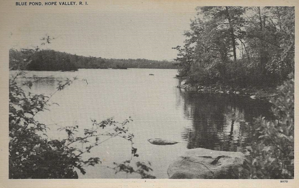
HOPKINTON — An old postcard depicts a narrow, winding road that walkers once took across a rustic bridge and an earthen dam to swim and enjoy the outdoors at the southern tip of Blue Pond.
These days, however, Blue Pond seems all but forgotten.
Hikers who want to follow old farm roads or cross granite ledges through dense forests to scenic ponds usually choose the nearby Narragansett Trail that skirts the banks of Ashville Pond and Long Pond. It’s a gorgeous walk.
But after hiking that trail several times, I wanted to try something new and headed east to walk on a path less traveled to Blue Pond. I actually found three separate dirt trails to the pond and was rewarded with some interesting sights.
Walking RI Stroll through industrial history in Slatersville, America's first planned mill village
Walking RI: Searching for clues about RI's early settlers on a walking tour of 5 Exeter cemeteries
How the historic 2010 floods changed Blue Pond
The water level in the pond dropped several feet after an old dam breached in 2010 and millions of gallons of water drained downstream, exposing once-underwater coves and a rocky shoreline.
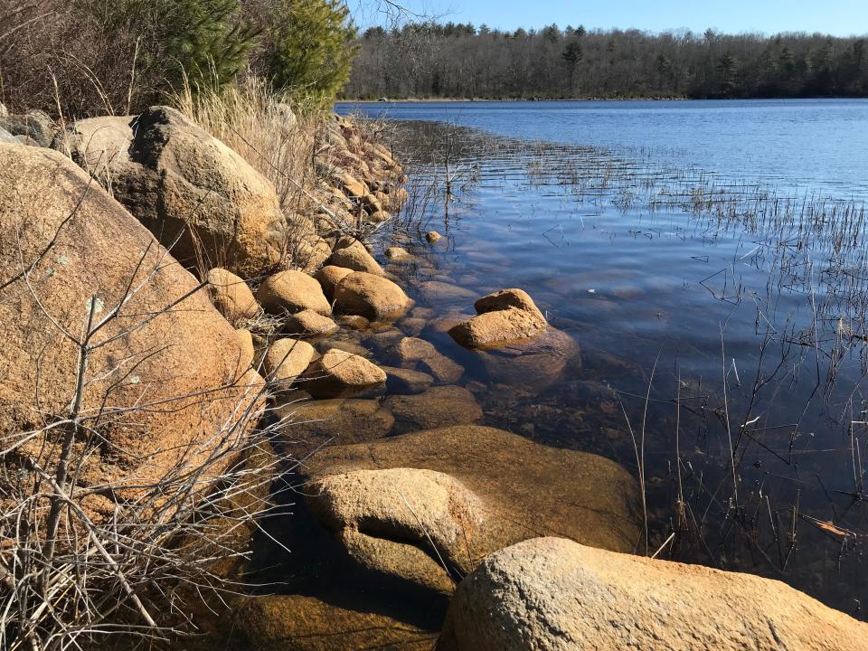
Stone foundations from long-abandoned cabins or mills can be seen on the banks. Smooth, sloping granite ledges run to the shoreline where locals once picked blueberries.
Today, mostly anglers and hunters frequent the area, and the old postcards bring back memories of an earlier era.
To find the hidden pond, I set out with a hiking buddy from a trailhead off Canonchet Road and walked east into 600 acres of protected land that is part of the state-owned Rockville Management Area. Some private parcels also surround the pond.
We used Ken Weber’s book “More Walks and Rambles in Rhode Island,” published in 1992, to help guide our walk.
The path starts out as an unmarked old farm road that passes through a thick tunnel of mountain laurel. Weber reported seeing the remains of a shack on one side of the trail and a fireplace on the other, but we couldn’t find either in the heavy underbrush. We did find an iron pipe half buried across the path that may have once been a water line.
Walking RI Up for a challenge? Tippecansett South Trail is a rigorous, rewarding workout
Remnants of the Ice Age, and an old cabin
We also noted rocky ravines to the right. On the left we spotted a high ridge. We took a side path to the top and found a line of ridges, which were formed during the Ice Age and that also deposited huge erratics along the path.
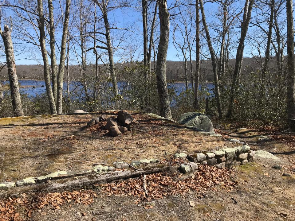
After about a half mile, we spotted Blue Pond through the trees to the east. Overlooking the pond is a rectangular, 27-by-18-foot stone foundation that was probably a cabin. We found a large stone threshold and rusted, vertical bolts that must have supported wooden walls. There was also an unusual square hole in a foundation wall that once had a door and may have been used for storage.
A short path behind the foundation led down a sloping ledge to the edge of the pond. It had clearly shrunk, based on the receded shoreline and waterline marks on the rocks.
Hikers report that cranberries once grew along the shore. We didn’t see any, but we did spot a canoe propped on the banks.
More: These 10 Rhode Island trails should be on your bucket list
Walking RI: See rugged coastline and 100-year-old ruins at Narragansett's Black Point
After returning to the foundation, we walked a few yards back up the trail and turned right and north on a path that crossed a ridge. We hoped to follow a loop trail that Weber described as circling the pond clockwise.
But after a couple hundred yards up and down ridges and across two small streams, the path vanished under a thick carpet of leaves, vines, downed branches and underbrush. We could have bushwhacked while keeping the pond to our right, but I worried about stepping in a hole hidden under the leaves, so we retraced our steps to the foundation.
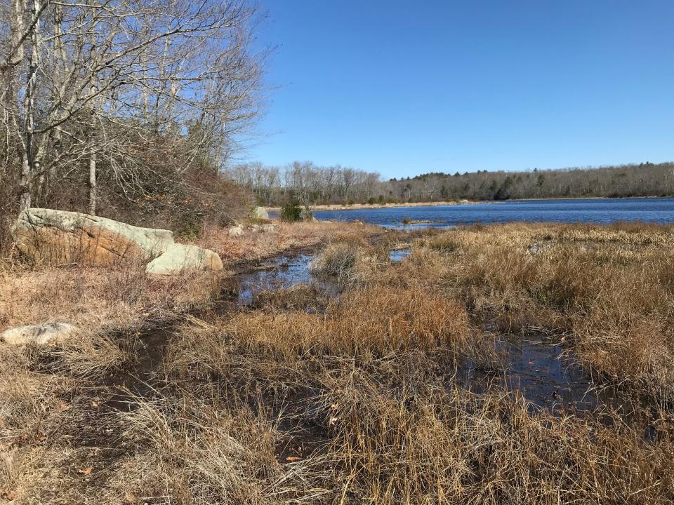
We found a path headed south and downhill to what once may have been a cove that was now a grass and reed-covered marsh. We followed a path around the cove and then back to the pond.
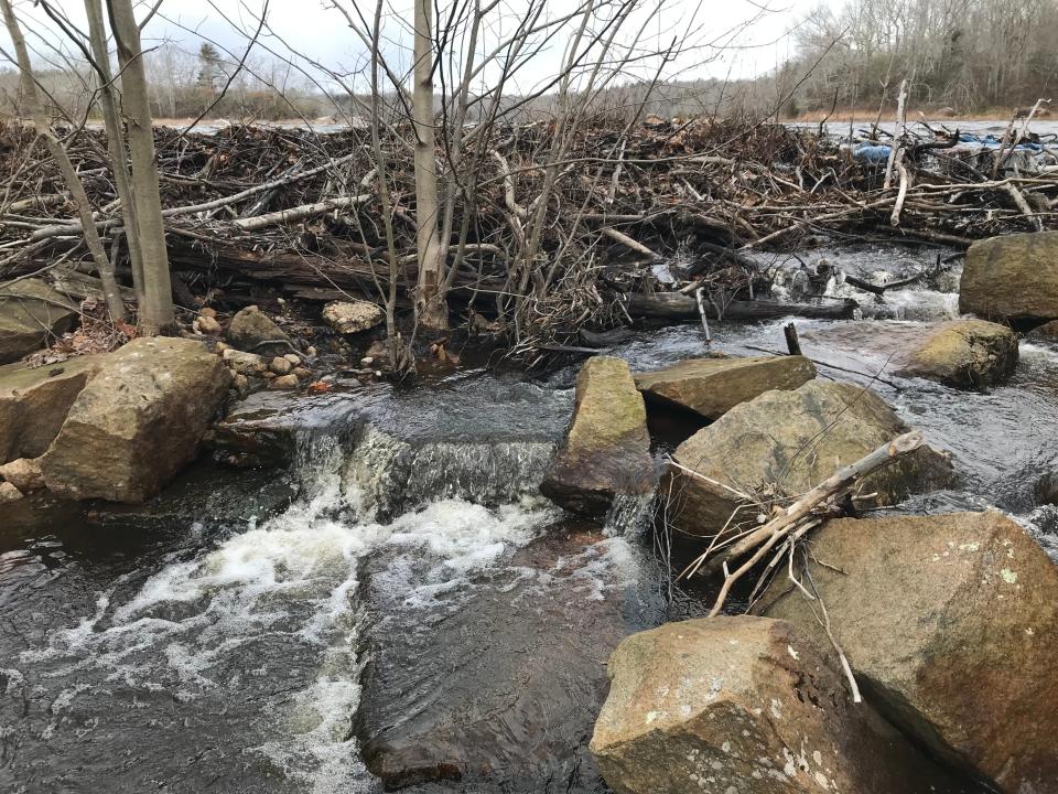
To the left, we spotted what had caused the pond to shrink: a huge gash in a long earthen, 170-year-old dam.
Warnings about the dam went unheeded
In 1848, Stephen Austin, the land owner, gave John D. Burdick permission to build the embankment for his sawmill, according to Lorraine Arruda, president of the Hopkinton Historical Association. The dam, at the outflow of a natural pond, tripled the size of Blue Pond.
The dike was later rebuilt, changed hands several times and deteriorated. In 2007 and 2008, Rhode Island Department of Environmental Management inspectors found the dam was in danger of failing and cited the corporate owners. Repairs were never made.
Walking RI: This Hopkinton RI trail was featured in Wes Anderson's 'Moonrise Kingdom'
In March 2010, after record rains, the dam collapsed, and 179 million gallons of water rushed through the woods, washing away roads, bridges and backyard buildings in Hopkinton and Richmond.
The DEM assessed fines, and after some negotiations the owners sold 67 acres, including the dam, for less than the assessed value to the state, which added the property to its wildlife management area.
There are no plans to repair the dam, DEM said.
We walked to the wide, earthen dike that’s 14 feet high and has rock walls on both sides. Trees line the walkway on top of the dam, and we spotted gnawed stumps where beavers had been at work.
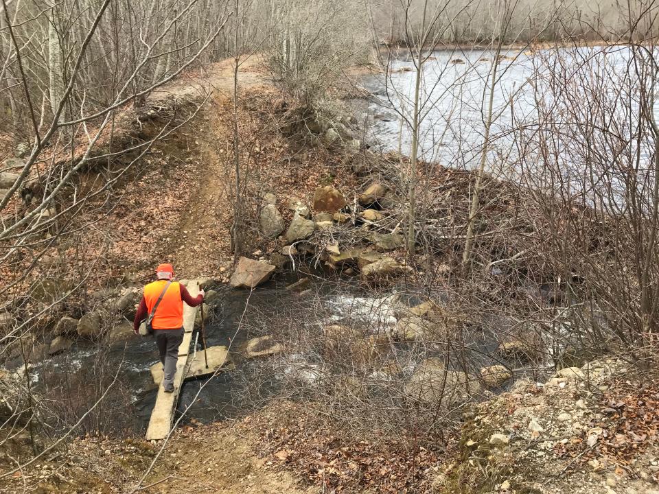
About halfway across the 1,000-foot dam, we came to the 25-foot missing section where the dam broke. We walked down a steep bank to cross a plank bridge over the water that was rushing over rocks and granite blocks. The water flowed through a wide floodplain and would eventually reach Canonchet Brook.
We climbed the embankment on the other side, crossed the rest of the dam and passed what looked like a spillway built with wooden timbers, perhaps created to take pressure off the dam.
The path led to a road that ran uphill to private property and a house. We turned and retraced our steps across the dam. At the end, we took a left on a dirt road that may have been the same one depicted in the old postcards.
Arruda, the local historian, grew up in the Blue Pond area. She told me she recalled walking along the old road that connected Canonchet Road and Fenner Hill Road to the west. She remembered crossing the dam and bridge and going swimming with friends at the southern end of the pond.
Walking RI: Spectacular bay views and Colonial and tribal history at Mount Hope Farm
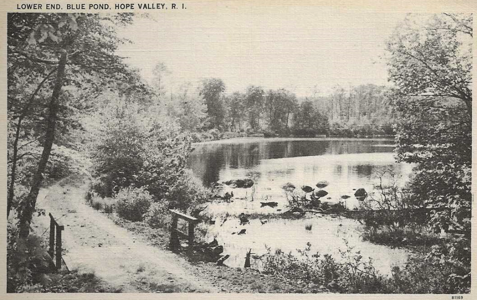
She also said the old postcards that Martha Baton, a local resident and former acting director of the Langworthy Public Library, found while I was doing research were made in the 1930s and 1940s to help promote the area.
As we walked a short distance down the road from the dam, we passed some flat ground with a foundation and a fireplace that may have been a cabin or small mill, perhaps the site of Burdick’s sawmill.
The road wound around granite erratics, crossed swamps and soon came to an iron gate with a huge boulder in front to stop vehicles from entering. We turned right and walked up the paved Canonchet Road to the lot where we'd parked. In all, we hiked 3.35 miles over 2½ hours.
Walking RI: Tillinghast Pond's trails are part of something special and well worth a visit
A newer trail offers views of Blue Pond's northern tip
I learned later that there is another newer trail to Blue Pond farther north, at the junction of Canonchet and North roads, that’s part of property the DEM acquired from the Allen family in 2018. I went back and followed a grassy road from that trailhead that ran about a half mile to the rock-lined, northern tip of Blue Pond, offering a good look at the tree-lined, undeveloped 90-acre pond. A canoe was on the shore.
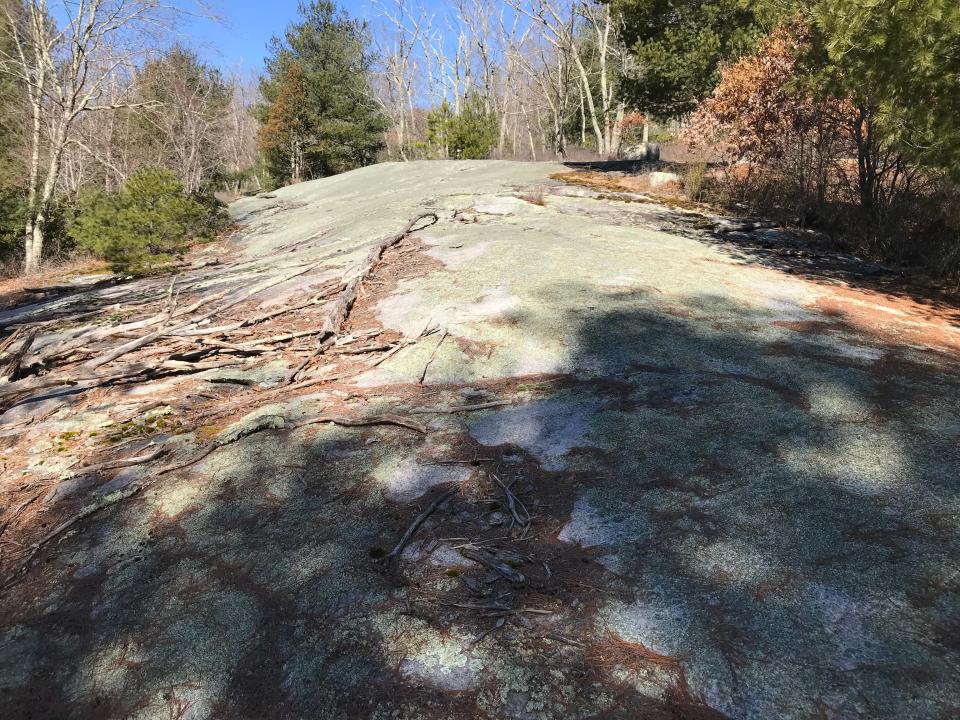
When I started back up the trail, I took a side path on the right to a long, smooth ridge that Weber had called a “Rock Mass.” It’s a good description, because the ledges, outcroppings and boulders extend for quite a distance in all directions.
Arruda told me one of her childhood friends lived in the area, and they walked to the ledges to go swimming and pick blueberries.
I explored the rocky slope, sat down, studied the pond and drank some water before returning to where I'd started after walking about 1.5 miles.
Walking RI: Looking for a great birdwatching spot? Try this former Navy site in North Kingstown
Walking RI: Mingle with birds, beavers, mink and more at Exeter's Fisherville Brook refuge
Blue Pond turned out to be a pleasant surprise. I was disappointed that the loop trail around the pond seemed to be long gone.
But the trails offered good exercise. There also was plenty to see and explore while thinking about the old days when the picturesque pond was the subject of postcards.
Trail tip: Wear orange for safety
From the third Saturday in April until May 31, all users of Rhode Island management areas are required to wear a minimum of 200 square inches of solid, day-glo fluorescent orange, such as a vest or hat, for safety during hunting season.
Violators are subject to a $100 fine.
If you go ...
Access: From Route 3, take Canonchet Road north and drive about 1.5 miles past Ashville Pond on the left to a marked trailhead on the right. A second trailhead is located farther north, just before the intersection with North Road.
Parking: Small lots are at both trailheads.
Dogs: Allowed but must be leashed.
Difficulty: Easy to moderate, with some rocky paths and ridges.
The Walking Rhode Island column appears every other Sunday in the Rhode Islander pages. John Kostrzewa, a former assistant managing editor/business, at The Providence Journal, welcomes email at johnekostrzewa@gmal.com.
This article originally appeared on The Providence Journal: Rediscover Hopkinton, RI's Blue Pond from three lesser-known trails

