Storm to pummel northwestern US with rain, snow and gusty winds this weekend
The stormy pattern continues for the Northwest as more rain and snow will arrive over the weekend, which could further disrupt holiday travel.
Heavy rain over the past weeks has already led to travel impacts. On Tuesday, heavy rain contributed to a mudslide that closed part of Washington's Route 109 and later spawned a tornado along the Washington coast.
Following another wave of wet weather Thursday, rain, snow and wind will return on Saturday and continue through the weekend.
Winds with this system are expected to lessen compared to previous storms; however, gusts to 40 mph will still be possible, especially in the higher elevations and along the Washington and Oregon coasts.
A wind gust of 111 mph was recorded on Mt. Baker on Thursday afternoon, according to the National Weather Service.
These wind gusts have contributed with power outages across the region with over 55,000 outages in northwestern Washington on Thursday afternoon.
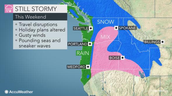
Despite less wind with this storm, wind speeds will be high enough to produce rough seas and surf. Pounding waves can also further attribute to coastal flooding and beach erosion.
Waves of heavy rain will reach the coastal parts of Washington and Oregon. Rain could be heavy enough at times that downpours could reduce visibility. This would cause difficult travel for those driving along I-5 anywhere from Seattle to Medford.
Meanwhile, precipitation will fall as snow in the Cascades.
This storm will bring cooler air than the last few systems. Because of this, there will be a noticeable drop in snow levels in the mountains.
"Snow levels are expected to drop in the Washington Cascades to around 1,500 feet Saturday night or early Sunday morning," said AccuWeather Senior Meteorologist Kristina Pydynowski.
This means that passes such as Snoqualmie and Stevens Pass are likely to get accumulating snowfall during this time.
Farther south, snow levels will be higher, keeping the accumulating snow out of the passes across much of the Cascades in Oregon.
Download the free AccuWeather app to see how much snow is expected for your area.
As the storm moves eastward Saturday night and Sunday, the effects of the storm will spread to interior parts of the Northwest.
"Cold air will be more locked in place the farther inland you go," Pydynowski added.
This means that along Interstate 84, in the higher terrain of northeastern Oregon, could receive snow. Snow will also mix with rain across the Snake River Valley in southern Idaho, including in the city of Boise.
Primarily snow will fall across the higher elevations across central Idaho and into western Montana. Additional snow will help ensure the chances of a white Christmas in the northern Rocky Mountains.
Just as the storm starts to let up Sunday night, another storm will arrive from the Pacific Ocean. This time, however, the storm track will be farther south.
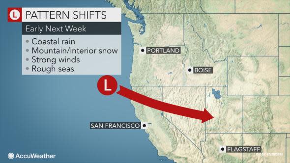
Instead of moving mostly west to east across Oregon and Washington, the storm early next week will enter the U.S. closer to the the Oregon-California border and dive southward.
Not only will this keep some of the steadier precipitation out of the Washington, but it will also draw colder air from Canada across the Northwest, allowing even more snow to fall in the interior parts of Oregon.
This new system is likely to spread rain and snow through much of Nevada and California in time for the Christmas holiday.
Some weaker waves of light rain and snow could follow for the rest of next week.

Click the above photo to test your weather prediction skills with Forecaster Challenge.
