Remember, Boise, it’s still summer. Here comes some excessive heat — then maybe rain?
Boise is poised for a Jekyll and Hyde week of weather, with heat that will produce record-breaking temperatures setting the stage for the chance of monsoonal moisture over the weekend.
The high temperature on Tuesday hit 104 degrees at 4:55 p.m., breaking the historical high for Aug. 15 of 103 degrees set in 2020. The National Weather Service also forecasts a potentially record-breaking high of 103 on Wednesday and 101 on Thursday. But a late-summer system coming from the southwest will bring Boise’s temperatures crashing down later in the week.
A hot start to the week
The extreme heat — which is about 12 degrees hotter than average for mid-August — has resulted in the Weather Service issuing a heat advisory from noon on Tuesday till 9 p.m. Wednesday.
The advisory warns of temperatures that “may cause heat illness to occur.”
Boise will be one of the hottest areas in the region on Tuesday, with the only nearby areas forecast to have hotter temperatures being Emmett and Weiser (103) and Glenns Ferry (104).
️Hot temperatures expected today through at least Thursday. Make sure to stay hydrated if you plan to spend time outside and wear sunscreen! #idwx #orwx pic.twitter.com/nfKcDRoOpE
— NWS Boise (@NWSBoise) August 15, 2023
Weather Service meteorologist Josh Smith told the Idaho Statesman that the heat advisory may extend into Thursday, but cloud coverage could result in temperatures dropping by then.
As of Tuesday morning, Smith said there is a 56% chance of 100 degrees or greater on Thursday.
Wednesday’s forecast of 103 will be under particular scrutiny — Boise’s all-time high temperature recorded on Aug. 16 is 103, which happened in 2020. With clear skies in the forecast, late-afternoon temperatures Wednesday could break that record.
Monsoonal moisture in Idaho
While the city will cook under the intense heat through the work week, a shift in the weather pattern will result in a cooler weekend that might even bring rain. High temperatures will drop to as low as 81 by Monday.
“A shift in the pattern could bring copious amounts of monsoon and tropical storm moisture into the Intermountain West as early as Friday,” Smith said.
The U.S. West is impacted by the North American Monsoon System, which happens when moisture from the Gulfs of California and Mexico is pulled northward through typically dry states such as Nevada and Utah. The ensuing storms follow a south-to-north track typically seen during a monsoon, eventually bringing rain toward Idaho.
The Weather Service forecasts a 20% chance of storms for Boise every day from Thursday through Monday, but those predictions will be fine-tuned later in the week.
“There remains uncertainty in how much moisture will make it over the area,” Smith said. “This could have implications for potential flash flooding into the weekend. We will be keeping a close eye on this system in the coming days.”
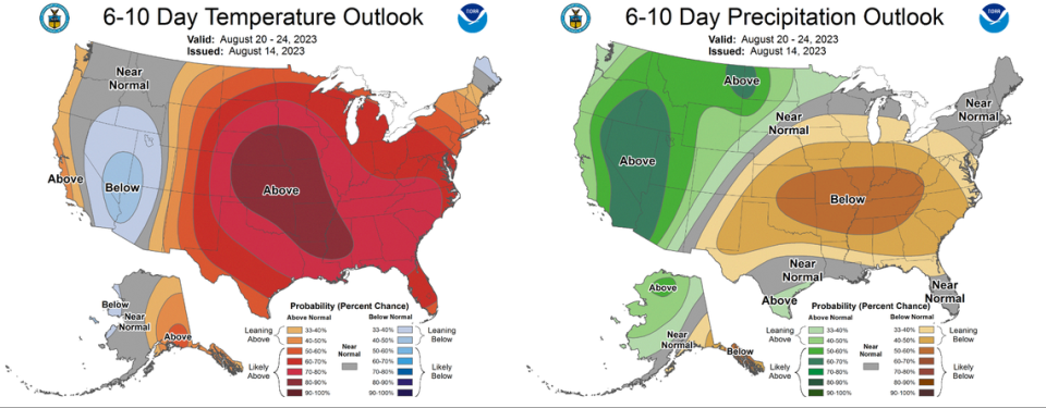
The Climate Prediction Center, a long-term forecasting system used by the National Oceanic and Atmospheric Administration, forecasts Boise to have a 60-70% chance of above-normal precipitation and a 33-40% chance of below-average temperatures over the next 10 days.