Reports: Intense storms erupt over Montana, North Dakota with high winds, tornadoes
As of 2:00 a.m. CDT Friday, the reports below are no longer being updated.
Damaging storms are impacting the north-central US and spinning up tornadoes across the region into Friday morning.
Moisture-rich air from the south will help to fuel severe thunderstorms across eastern Montana, northeastern Wyoming, North Dakota and northern South Dakota into the overnight hours.
This includes a stretch of Interstate 94 extending hundreds of miles across the region. Motorists driving on this highway should be prepared for weather-related delays.
The strongest storms will be capable of producing winds over 70 mph, baseball-sized hail and even tornadoes.

12:50 a.m. CDT Friday:
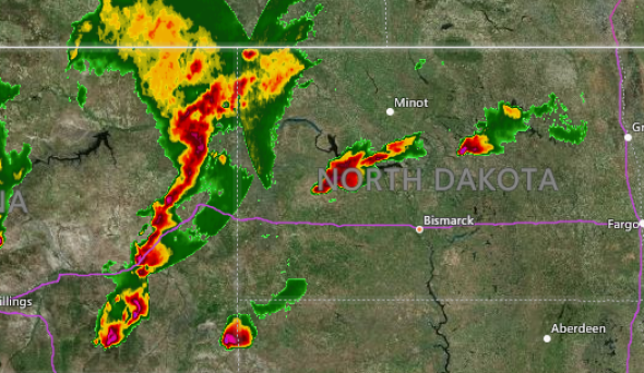
Residents in Bismarck, North Dakota, are about to get rattled by severe storms that are sweeping in from the west.
The city is under a severe thunderstorm warning until 1:45 a.m. CDT, with wind gusts up to 70 mph possible with the storms.
Storms continue to push across North Dakota early this morning. Update 6/29 12:44 AM CDT #ndwx #sdwx pic.twitter.com/qtExpiKAzE
— NWS Aberdeen (@NWSAberdeen) June 29, 2018
11:40 p.m. CDT Thursday:
In addition to unleashing high winds, the severe storms rumbling across the northern Plains are dumping a tremendous amount of rainfall which is leading to flash flooding.
In Mercer County, North Dakota, 5.25 inches of rain fell within three hours.
The heavy rainfall caused ditches to overflow with water and flood neighboring roads near Halliday, North Dakota, according to local law enforcement.
10:30 p.m. CDT Thursday:
Wind gusts between 70 and 80 mph have been reported with an intense line of storms sweeping through western North Dakota. Winds of this magnitude can easily flip over tractor trailers and snap trees and power lines.
With the threat of severe weather continuing well after dark, residents across North Dakota and even into northwest Minnesota are encouraged to keep cell phones on and fully charged with severe alerts enabled before heading to bed.
1015 pm radar update, a line of severe thunderstorms was moving across parts of wrn ND. They were also producing torrential rain. pic.twitter.com/9gJiCEVaMV
— NWS Bismarck (@NWSBismarck) June 29, 2018
9:30 p.m. CDT Thursday:
A storm that produced tornadoes in southeast Montana has crossed over into South Dakota and is producing a large tornado in Harding County, South Dakota.
#SDwx pic.twitter.com/lrwLwb5fRd
— Spencer Armlin (@spencerarmlin) June 29, 2018
Large Tornado still on the ground near Capitol in southeastern Carter County Montana heading east toward the Dakota border. #mtwx #sdwx
— NWS Billings (@NWSBillings) June 29, 2018
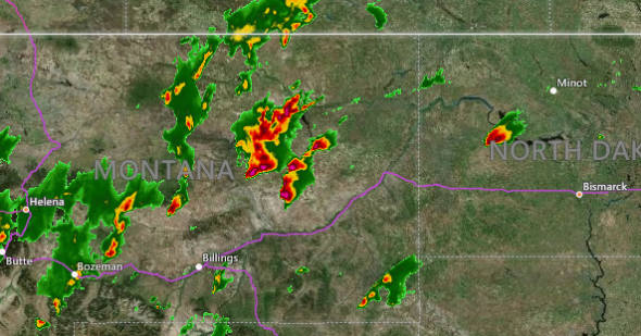
8:55 p.m. CDT Thursday:
A line of severe storms has developed in eastern Montana with isolated supercell thunderstorms east of the line. A tornado has been confirmed by several trained spotters near Capitol, Montana.
8:15 p.m. CDT Thursday:
The same thunderstorm that spun up a brief tornado near Halliday, North Dakota, earlier this evening is once again capable of producing a tornado. This is a slow-moving thunderstorm and may cause flooding as heavy rain persists over the same areas.
Tornado Warning including Halliday ND until 7:45 PM MDT pic.twitter.com/iIFWqSIrKz
— NWS Bismarck (@NWSBismarck) June 29, 2018
7:50 p.m. CDT Thursday:
AccuWeather Extreme Meteorologist Reed Timmer confirmed that a tornado touched down earlier this evening near Halliday, North Dakota. The tornado has since lifted and lifted some vegetation in the area.
Tornado touched down 10 minutes ago about 5-6 miles west of Halliday, ND around 6:25 pm. Close range vortices lifting tumbleweeds, small bushes with funnel above @NWSBismarck @breakingweather
— Reed Timmer (@ReedTimmerAccu) June 29, 2018
6:30 p.m. CDT Thursday:
Severe thunderstorms are starting to become more widespread in eastern Montana and western North Dakota with several storms capable of producing large hail.
4:15 p.m. CDT Thursday:
A strong thunderstorm is gaining strength in western North Dakota. AccuWeather Extreme Meteorologist Reed Timmer is near Watford City and is intercepting the storm.
Update: storm strengthening west of Watford City, ND as of 4:13 pm and appears to have split. @breakingweather pic.twitter.com/SUkpU53mHd
— Reed Timmer (@ReedTimmerAccu) June 28, 2018
3:20 p.m. CDT Thursday:
The National Weather Service has issued a tornado watch for much of North Dakota. A few tornadoes are likely in this area, as well as wind gusts to 70 mph and very large hail.
3:18pm CDT #SPC_Watch WW 234 TORNADO ND 282015Z - 290400Z, #ndwx, https://t.co/NOVjffRNmv pic.twitter.com/RWawQsqrUo
— NWS SPC (@NWSSPC) June 28, 2018

