Reports: Deadly storms trigger flooding and tornadoes across Mississippi, Ohio valleys
As of 1:30 a.m. CST Sunday, the reports below are no longer being updated. Click here for a recap of the severe storms.
Three people have died and multiple structures have been damaged in severe weather hitting the central United States.
Damaging thunderstorms are targeting an area that has been hit by heavy rain and rising floodwaters in recent days.
Through the early morning hours on Sunday, the greatest risk to lives and property will stem from strong straight-line wind gusts and flash flooding across the Ohio and Tennessee valleys.
However, there is also a risk of isolated tornadoes being spawned by the strongest thunderstorms.
11:25 p.m. CST Saturday:
A third death has been reported during the severe weather outbreak.
According to ABC News, one fatality has been confirmed in Arkansas. Two other deaths were previously reported in Kentucky and Tennessee.
11:00 p.m. CST Saturday:
Widespread flooding is occurring around the Louisville, Kentucky, metro area. Cars are reportedly floating in draining ditches just south of the city.
A nearby elementary school measured over 4 inches of rain since Saturday morning.
@NWSLouisville @Etownpd @MarcWeinbergWX @BGoodeWAVE3 Flooding is occurring off of Ring road in etown. Just past Freeman Lake. Water is moderately deep. pic.twitter.com/8rqbrJWJ9d
— Chris (@Chris_Evans52) February 25, 2018
9:45 p.m. CST Saturday:
There is a Flash Flood Emergency for Louisville, Kentucky.
The NWS said with the new downpours working in, severe to potentially catastrophic flash flooding will be possible.
Torrential rain and severe flash flooding are expected, especially across southern Indiana and north central Kentucky. Louisville, with its reduced drainage efficiency typical of urban areas, has already seen severe flooding.
Emergency management personnel are doing water rescues.
FLASH FLOOD EMERGENCY for metro Louisville. Line of storms with torrential rainfall moving into the area. Numerous water rescues ongoing already. This is an extremely dangerous flash flooding situation. Turn around, don't drown when encountering flooded roads! #kywx #lmkwx
— NWS Louisville (@NWSLouisville) February 25, 2018
8:10 p.m. CST Saturday:
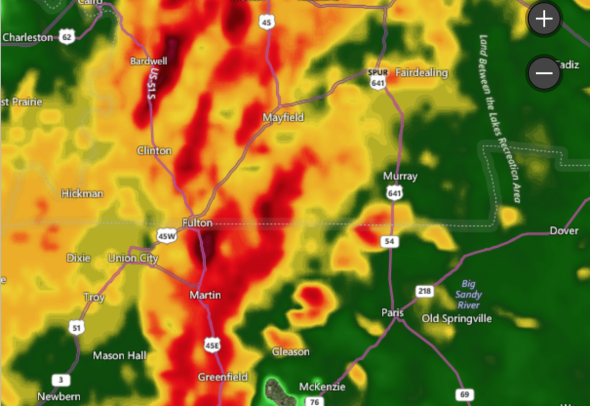
Tornado debris signature northeast of Paris, Tennessee. It is moving northeast. If you're in Henry County between Paris and Paris Landing, take cover now!
810pm: #tornado debris signature NE of #Paris. Moving NE. If you're in Henry Co between Paris and Paris Landing, take cover now! pic.twitter.com/sLVA4Iq7wW
— NWS Memphis (@NWSMemphis) February 25, 2018
7:50 p.m. CST Saturday:
Dangerous tornado warned supercell with strong rotation is approaching Clarksburg and Parkers Crossroads, Tennessee. Take cover now!
CLARKSBURG, Parkers Crossroads, TN: take cover now!! Dangerous #tornado warned supercell with strong rotation is approaching as of 7:50 pm! @breakingweather #tnwx #tornadowarning pic.twitter.com/TKMYYWwRtx
— Reed Timmer (@ReedTimmerAccu) February 25, 2018
7:45 p.m. CST Saturday:
Still multiple tornado warnings in northwest Tennessee and southwest Kentucky including west-southwest of Murray, Kentucky and heading toward McKenzie, Tennessee. If you are in a red box, take cover!
Still multiple #tornado warnings in northwest TN/southwest KY including just WSW of Murray, KY and heading toward McKenzie, TN! Also west of Puryear. Take cover in red boxes! @breakingweather #kywx #tnwx pic.twitter.com/KBeva08axm
— Reed Timmer (@ReedTimmerAccu) February 25, 2018
7:40 p.m. CST Saturday:
A tornado-producing severe thunderstorm is over Palmersville, Tennessee moving east. Take cover now!
7:00 p.m. CST Saturday:
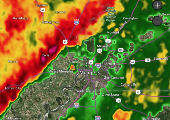
Severe storms are approaching the Memphis metro are now. Wind gusts of 60 mph or more are likely, as well as flash flooding as these storms move into western Tennessee.
6:30 p.m. CST Saturday:
Particularly dangerous situation radar indicated a large tornado on the ground in Luxora, Arkansas moving northeast. Take cover now!

6:06 p.m. CST Saturday:
There are reports of two deaths in the Logan County, Kentucky after an unconfirmed tornado swept through the area.
According to New Channel 5, the sheriff in Logan County, Kentucky confirmed an elderly woman was killed when she was hit by debris.
The second fatality was in Franklin, Kentucky due to drowning in a submerged vehicle.
BREAKING: The @wbkotv newsroom confirms two are dead in the Keysburg community of Logan Co after an apparent tornado this afternoon. #kywx
— Shane Holinde (@Main_Event_Wx) February 25, 2018
These fatalities are the first tornado related deaths in the United States since May 16th, 2017.
A fatal tornado has been confirmed in Logan County, Kentucky. The twister destroyed a home, killing at least one person in its path. pic.twitter.com/rQn9SOQvxT
— Medina StormCast (@MedinaStormCast) February 25, 2018
5:20 p.m. CST Saturday:
Damaging winds tore parts of a roof off of a building in West Memphis, Arkansas.
CR 136 near Westside School W of Jboro @NWSMemphis @ryanvaughan @Coulter_wx @arwx pic.twitter.com/w0h3iAErAt
— Trey Stafford (@Trey1049) February 24, 2018
5:20 p.m. CST Saturday:
Numerous tornado warnings are in effect northeast of Jonesboro, Arkansas up to the southeast Missouri border as of 5:15 pm CST.
Multiple #tornado warnings in effect just northeast of Jonesboro, AR up to the southeast MO border as of 5:15 pm! Take cover in warned areas @breakingweather #arwx pic.twitter.com/AVET62fdmi
— Reed Timmer (@ReedTimmerAccu) February 24, 2018
4:30 p.m. CST Saturday:
Due to the saturated soil, trees will be especially susceptible to falling even in moderately windy conditions. This could lead to blocked roads and damaged power lines across the affected region.
INTENSE squall line with flash flood "surge" pushing flood waters, debris west to east. Road is closed east of Jacksonville, AR! @breakingweather #flashfloodwarning pic.twitter.com/3ATgTLcdFG
— Reed Timmer (@ReedTimmerAccu) February 24, 2018
3:30 p.m. CST Saturday:
There is a tornado warning in northeast Arkansas for a strong rotation heading in the direction of the Mountain View, Arkansas area.
TORNADO WARNING in northeast AR for strong rotation heading in the direction of the Mountain View, AR area as of 330 pm! @breakingweather #arwx pic.twitter.com/6MrxCfv2zr
— Reed Timmer (@ReedTimmerAccu) February 24, 2018
A Tornado Warning was issued for Franklin, Kentucky.
Tornado Warning issued for Franklin Kentucky KHPX - Super-Res Reflectivity Tilt 1 3:11 PM MST #kywx #tnwx pic.twitter.com/CWaV1kVfkO
— Brandon Houck (@HouckisPokise) February 24, 2018

