Reports: Severe weather erupting across central, southeastern US
As of 11:30 p.m. EDT Monday, this story is no longer being updated.
Rounds of severe thunderstorms rumble across the central and southeastern United States as the risk of severe weather expands eastward.
Storms from Kentucky, eastern Tennessee and southwestern Virginia to much of the Carolinas may pack a punch in terms of torrential rainfall, gusty winds and frequent lightning.
Severe weather is also expected to continue to pester the Plains for the next few days, threatening millions with flooding downpours, damaging winds, hail and even a few tornadoes.
Strong, gusty storms have sparked over the Plains each night this past weekend.

10:00 p.m. EDT Monday:
According to Channel 2 Action News WSB-TV, a 14-year-old Boy Scout died after a tree fell on his tent in Newton County, Georgia.
The incident happened as violent storms moved through the area Monday afternoon. Although a severe weather warning was never issued, Meteorologist Samantha Mohr said that wind gusts reached between 40 to 50 mph as the storms moved through Covington, Georgia. Winds of this magnitude are still enough to bring down weakened trees.
8:50 p.m. EDT Monday:
Damage was reported to an Exxon gas station on Highway 14 in Greer, South Carolina, after damaging winds blew through the area.
Multiple trees are reported down in the area, as well.
@NWSGSP: 7:00 pm. Relaying report of dmg to Exxon gas station on HWY 14 in Greer. A large tree was uprooted on same road, nearby. Also, tree reported down due to dmg wind on Glendale Clifton Rd. near HWY 176 in #Spartanburg co. Time unknown. #gspwx #scwx pic.twitter.com/wPSvcWq8si
— Upstate Weather SC (@Wxemergencydpt) June 26, 2018
8:45 p.m. EDT Monday:
Storms from Kentucky, eastern Tennessee and southwestern Virginia to much of the Carolinas will spread torrential rainfall, gusty winds and frequent lightning.
There are many reports of downed trees and power lines across the southeastern United States due to damaging wind gusts.
CLOSE CALL! These 40-foot tall trees near Florence County were cut down during the storms tonight.
Have pictures of storm damage in your neck of the woods? Email us: news@wmbfnews.com pic.twitter.com/HOFtkBUmqg— WMBFNews.com (@wmbfnews) June 26, 2018
8:27 p.m. EDT Monday:
A Severe Thunderstorm Warning has been issued for Calhoun, Clarendon, Orangeburg and Sumter, South Carolina.
This is severe outflow convergence (might of made that up) occurring right now. Stay safe guys!!!
KCAE - Super-Res Reflectivity Tilt 1 8:24 PM EDT #scwx pic.twitter.com/Wh5KOXP3V5— SouthCarolina_wx (@SCweather_wx) June 26, 2018
7:15 p.m. CDT Monday:
A Severe Thunderstorm Warning has been issued for St. Louis, Missouri.
7:08 p.m. CDT Monday:
Tornado warnings continue for Winterset and Beaconsfield, Iowa.
Tornado Warning continues for Winterset IA until 7:15 PM CDT pic.twitter.com/GEfVaskg5y
— NWS Tornado (@NWStornado) June 26, 2018
5:38 p.m. EDT Monday:
Approximately 80,000 customers are without power in the Carolinas and Georgia. The line of storms is still in western parts of North and South Carolina, so outage numbers could climb.
~80,000 customers w/out power in Carolinas, Georgia after line of storms moves through... SO FAR... line is still in western parts of North & South Carolina. https://t.co/0V2xSKKBV3 #ncwx #scwx pic.twitter.com/etXDmsODGA
— Jesse Ferrell (@Accu_Jesse) June 25, 2018
5:00 p.m. CDT Monday:
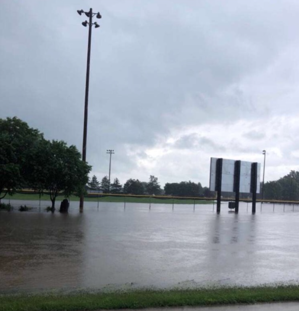
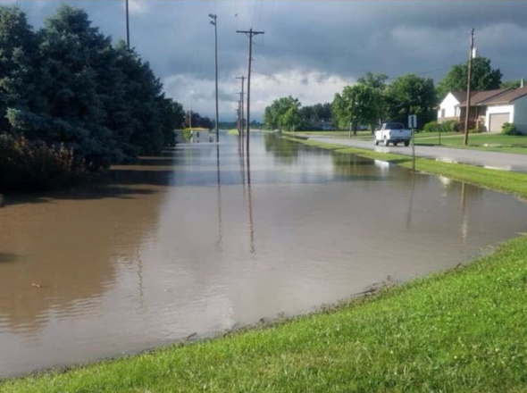
Law enforcement reports flash flooding and numerous roads under water near Pender, Nebraska. Submerged roads have been reported on Highways 94, 9 and 16 near Pender, Nebraska.
New closures:
Flooding near Pender has caused the closure of Route 9/16 and Route 94 east of Pender.
Flooding near West Point and Scribner has Highway 275 closed in multiple areas. pic.twitter.com/JK0Pq4RWOm— NEStatePatrol (@NEStatePatrol) June 25, 2018

Flooding in Pender, Nebraska. (Image via Dan Wichman)
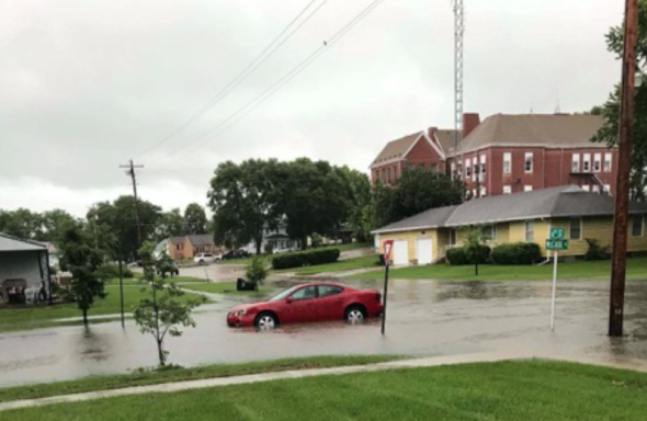
Cars submerged due to flooding in Pender, Nebraska. (Image via Shelby Anderson)
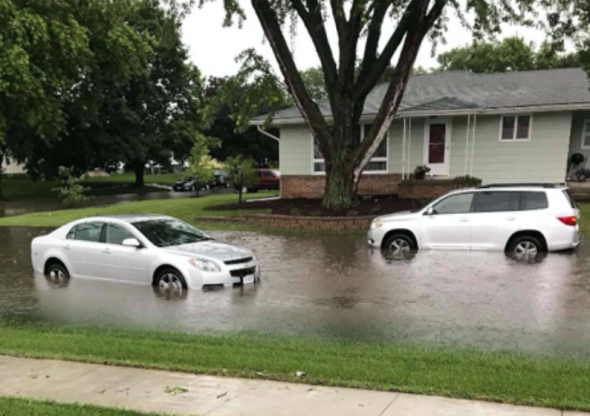
Cars submerged due to flooding in Pender, Nebraska. (Image via Shelby Anderson)
Flooding in Pender, Nebraska. (Image via Raegan Anderson)
Flooding in Pender, Nebraska. (Image via Raegan Anderson)
4:38 p.m. CDT Monday:
Funnel clouds can't be ruled out in this evening's storms. Flooding downpours, damaging winds and hail are also among the possibilities from these severe storms.
These are the types of funnel clouds that could occur this afternoon & evening. This one spotted in Clay County within the last few minutes #NEwx https://t.co/gIpKs8Lodv
— NWS Hastings (@NWSHastings) June 25, 2018

