Reports: Severe weather outbreak closes out weekend in central US
As of 4:30 a.m. CDT Monday, this story is no longer being updated.
A severe weather outbreak closed out the first weekend of summer with damaging storms threatening parts of the central U.S.
Additional rounds of severe thunderstorms will rumble across the central US this week as the risk of severe weather expands eastward.

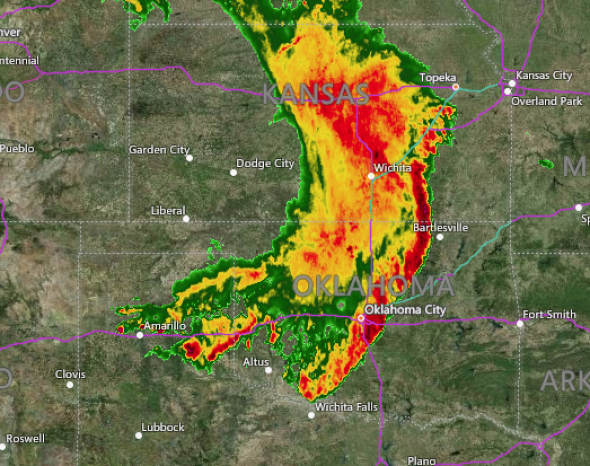
3:15 a.m. CDT Monday:
As the severe storms moved through central Oklahoma, wind gusts of 64 mph were reported in McClain County and Cotton County, to the south and southwest of Oklahoma City.
The storms are bearing down on Bartlesville and Tulsa, Oklahoma, and are still capable of producing wind gusts in excess of 60 mph.
2:00 a.m. CDT Monday:
There is a severe thunderstorm warning in effect for Oklahoma City, Norman, Moore and El Reno, Oklahoma, and surrounding communities until 2:45 a.m. CDT Monday.
These storms have already produced a wind gust of 73 mph in El Reno. Widespread tree and roof damage is likely.
Nearly 60 percent of people in Ellis County, Oklahoma, are currently without power as a consequence of the storms.
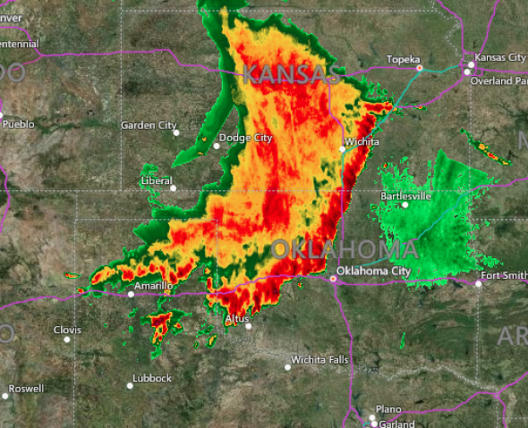
12:45 a.m. CDT Monday:
A severe thunderstorm watch has been issued for southern Kansas and much of central and eastern Oklahoma, including Oklahoma City and Tulsa, until 8 a.m. CDT Monday.
While the threat for tornadoes is diminishing, these storms will still be capable of producing wind gusts greater than 60 mph and destructive hail as they dive southeastward.
Even though the strongest storms stayed south of Wichita, winds still gusted to nearly 50 mph on the northern flank of the squall line.
A severe thunderstorm watch has been issued for parts of Kansas and Oklahoma until 8 AM CDT pic.twitter.com/o1JNbdGElC
— NWS Wichita (@NWSWichita) June 25, 2018
11:45 p.m. CDT Sunday:
Strong to severe thunderstorms that have a history of producing large hail and wind damage are approaching Wichita, Kansas. While the worst storms should remain just to the south of Wichita, gusts of 40-50 mph and torrential downpours are likely.
11:48pm...Our skycam is picking up a vivid lightning display west and northwest of Wichita. #kswx pic.twitter.com/36kxoWseeS
— NWS Wichita (@NWSWichita) June 25, 2018
10:45 p.m. CDT Sunday:
Golf-ball sized hail has been reported near Boise City, Oklahoma, while a 62-mph wind gust occurred near Perryton, Texas. A semi-trailer was blown over and into a building near Cimarron, Kansas, as the destructive storms rolled through the area.
The storms continue to merge into a squall line as they race southeastward through southern Kansas and the Texas and Oklahoma Panhandles.
10:10 p.m. CDT Sunday:
In addition to damaging winds, hail and isolated tornadoes, frequent cloud-to-ground lightning is being produced by the storms. Anyone outside should move indoors as soon as lightning is seen or thunder heard.
NEW: backside of severe storms over Clayton, NM with incredible lightning @breakingweather @accuweather pic.twitter.com/rvQBEo9gZn
— Reed Timmer (@ReedTimmerAccu) June 25, 2018
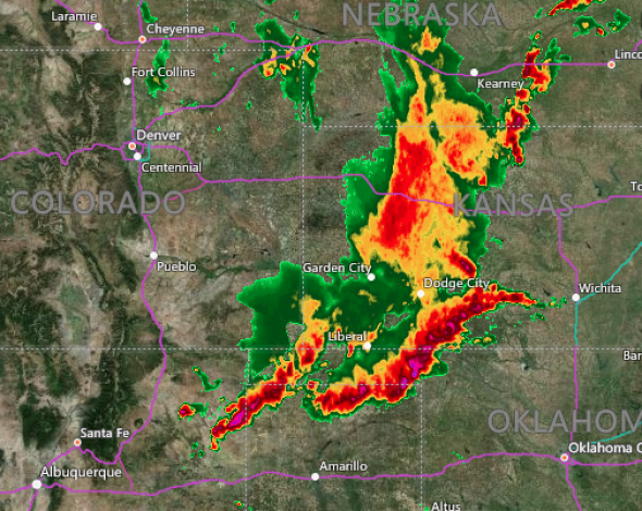
9:45 p.m. CDT Sunday:
Severe thunderstorms capable of producing damaging wind gusts of 70 mph and large hail are impacting Dodge City, Kansas, and surrounding areas. A wind gust of 68 mph was reported as the storms ripped through Liberal, Kansas.
Winds of this magnitude threaten to produce property damage and can down trees and power lines.
Severe Thunderstorm Warning including Dodge City KS, Larned KS, Kinsley KS until 10:30 PM CDT pic.twitter.com/OlzYZLwsj6
— NWS Dodge City (@NWSDodgeCity) June 25, 2018
8:30 p.m. CDT Sunday:
A funnel cloud was spotted earlier this afternoon near Plevna, Montana.
Spotter sent in this photo of a #FunnelCloud from this afternoon near #Plevna in Fallon county. #MTwx pic.twitter.com/sBYf9FaDT1
— NWS Billings (@NWSBillings) June 25, 2018
7:30 p.m. CDT Sunday:
A Trooper reported three funnel clouds formed at the same time near Dorchester, Nebraska around 7:30 p.m. CDT.
This picture was taken approximately 30 mins ago by Trooper Stahl #275 looking west from Dorchester to the South of Friend. 3 funnel clouds forming at the same time. 1 barely reached the ground, then all 3 went back up. #LivePD #newx #Tornado pic.twitter.com/egCaFvOEaZ
— NSP Trooper Cook (@NSP_TroopHQ) June 25, 2018
7:27 p.m. CDT Sunday:
Large hail has fallen in the outskirts of Des Moines, New Mexico.
Large hail just outside of Des Moines, NM @breakingweather pic.twitter.com/KCDjOYBzHC
— Reed Timmer (@ReedTimmerAccu) June 25, 2018
7:02 p.m. CDT Sunday:
Large hail is falling in Capulin Volcano, New Mexico with a wall cloud forming rapidly.
NEW: wall cloud forming rapidly on east side of Capulin Volcano, NM with big hail falling! @breakingweather #nmwx pic.twitter.com/mOxFIfeakG
— Reed Timmer (@ReedTimmerAccu) June 25, 2018
6:20 p.m. CDT Sunday:
There is a Flash Flood Emergency for Dickinson County after multiple reports of vehicles submerged or stalled in the Iowa and Great Lakes area. Don't drive through flooded roads and refrain from driving at all if possible.
RT @NWSSiouxFalls: 620 PM: This is a Flash Flood Emergency for Dickinson County including Spirit Lake! We are expecting 3 to 6 inches of rain. Reports of cars stalled. If you see water over the road, TURN AROUND, DON'T DROWN!
— NWS Sioux Falls (@NWSSiouxFalls) June 24, 2018
Many roads are flooded again across the county especially on the west side. Use caution if driving tonight. Do not drive through flooded roads.#TurnAroundDontDrown pic.twitter.com/6aqtG2RYzM
— Dickinson County (Iowa) Emergency Management (@dcoem) June 25, 2018
There are also Flash Flood Warnings for Vermillion South Dakota, Hawarden Iowa and Elk Point South Dakota until 11:00 p.m. CDT.
5:40 p.m. CDT Sunday:
At 5:35 p.m. CDT, a confirmed tornado was located near Peever and Sisseton, South Dakota moving north at 15 mph.
Tornado Warning including Sisseton SD, Peever SD until 6:00 PM CDT pic.twitter.com/Vklu9DjX7I
— NWS Tornado (@NWStornado) June 24, 2018
5:32 p.m. CDT Sunday:
There is a Tornado Warning for Slayton, Currie and Avoca, Minnesota, until 6:15 p.m. CDT.
Tornado Warning including Slayton MN, Currie MN, Avoca MN until 6:15 PM CDT pic.twitter.com/AL5QbzRD6n
— NWS Tornado (@NWStornado) June 24, 2018
4:11 p.m. CDT Sunday:
A tornado from the tornado warned storm has been observed in Arco, Minnesota. Take cover if you are in the warning area.
Here is a picture from the tornado warned storm from 3:52pm northeast of Arco. Take cover if you're in the warning! #mnwx pic.twitter.com/AN85bIjQR1
— NWS Sioux Falls (@NWSSiouxFalls) June 24, 2018
3:45 p.m. CDT Sunday:
There is a Tornado Warning for Arco, Minnesota as well as for Lincoln County, Minnesota until 4:15 p.m. CDT Sunday.
Tornado Warning including Arco MN until 4:15 PM CDT pic.twitter.com/AY6SnUBmcT
— NWS Tornado (@NWStornado) June 24, 2018
11:30 a.m. CDT Sunday:
AccuWeather Extreme Meteorologist Reed Timmer is in the central United States and will be intercepting severe thunderstorms across the region on Sunday afternoon.
Target area, 24 June 2018: Outflow boundary (OFB) will stall in the TX Panhandle and slowly lift north/wash out with air mass destabilizing through afternoon. OFB will be focus for intense supercell development by 4-5 pm in northern TX/OK Panhandle, with #tornado or two possible pic.twitter.com/ZbqhrhHOie
— Reed Timmer (@ReedTimmerAccu) June 24, 2018

