Reports: Snowstorm ramps up in Northeast after turning deadly in Midwest
This reports story is no longer being updated. For the latest updates, please click here.
The snowstorm that caused nearly a thousand flights to be canceled at Chicago's O'Hare International Airport is expected to bring difficult and dangerous travel to a large swath of the Northeast through at least Sunday.
A state of emergency has been declared in Pennsylvania and New Jersey ahead of the storm's arrival. This includes vehicle restrictions on highways across the states.
"Feet of snow, blizzard conditions, a significant build-up of ice, tree-breaking winds and plunging temperatures will close roads, cause flight cancellations and disrupt daily activities over a large part of the northeastern United States this weekend," AccuWeather Senior Meteorologist Alex Sosnowski said.
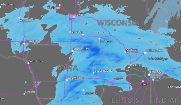
Major snowstorm pounds Midwest, Northeast
AP Photo/Garret Fischer


First, at vero eos et accusamus et iusto odio dignissimos ducimus qui blanditiis praesentium et accusamus et iusto odio dignissimos ducimus qui voluptatum.


(Instagram/murphy_thelabrador)
A pup in Naperville, Ill., enjoyed the snow on Saturday, Jan. 19.

(Photo/Dan Eidsmoe)
Snow blanketed Chicago on the morning of Saturday, Jan. 19, 2019.

(PhotoDan Eidsmoe)
Heavy snow piled up on Chicago's streets and sidewalks on Jan. 19, 2019.

(Photo/Dan Eidsmoe)
Morning snow created picturesque scenes in Chicago on Jan. 19, 2019.

(Photo/Dan Eidsmoe)
Crews worked to clear sidewalks of snow amid an intense storm on Jan. 19, 2019.

(Instagram/daniel_eidsmoe)
Early morning snow made for difficult travel conditions around Chicago on Jan. 19.

(Instagram/chickenkrispy)
Snow coated roads and sidewalks in downtown Chicago on Saturday, Jan. 19.

(Twitter/ISPDistrcit21)
At least two semi-trucks and a handful of other vehicles slid off roadways around Danforth, Ill., on Saturday, Jan. 19, local officials reported.

(Instagram/414films)
Pedestrians worked their way through packed sidewalks in Milwaukee, Wisc., on Jan. 19.

(Instagram/chrissiwit)
Roads were unsafe for travel in Milwaukee, Wisc., on Saturday, Jan. 19, 2019.

(Twitter/ISPDistrict21)
Visibility was severely poor in parts of eastern Illinois on Saturday afternoon amid a massive snowstorm.

(Instagram/@catahoula_dex)
While the storm may have caused travel chaos in Chicago, some animals made the most of it.

(Twitter/ODOT_Statewide)
The Ohio Department of Transportation had thousands of crews on roads across the state as a major storm hit the region on Jan. 19.

(Instagram/chancegolden2018)
A playful pup was barely visible in the heavy snow that blanketed Milwaukee, Wisc., on Jan. 19.

(Twitter/MSHPTrooperC)
A crash on a snow-covered I-55 closed part of the highway in Sainte Genevieve County in eastern Missouri on Saturday, Jan. 19, 2019.

(Twitter/MSHPTrooperI)
Officials in Dent County, Missouri, said the area experience the "worst of the snow" in that region on Twitter on Saturday, Jan. 19, 2019.

(Photo/h_coker89)
Icy roads forced this driver, who was unhurt, off the road in Arkansas on the morning of Saturday, Jan. 19.

Meghan Mussoline
Thick snow fell in State College, Penn., on Saturday, Jan. 19, 2019, but Chester the dog was unsure about the conditions.

(AP Photo/Keith Srakocic)
A Pennsylvania Department of Transportation road treatment truck pulls in to attach a plow at a storage facility in Franklin Park, Pa. on Friday, Jan. 18, 2019. Weather forecasters are are predicting a heavy weekend snow storm across Pennsylvania and surrounding states.

IowaDOT
A plow truck drove down a snow-covered stretch of Interstate 80 east of Des Moines, Iowa.

(AP Photo/Paul Sancya)
Pedestrians walk in the snow in Detroit, Saturday, Jan. 19, 2019.

(AP Photo/Paul Sancya)
A vehicle spins out on Interstate 94 in Detroit, Saturday, Jan. 19, 2019.

(AP Photo/Hans Pennink)
Crews clear snow at the Albany International Airport in Colonie, N.Y., Sunday, Jan. 20, 2019.

(AP Photo/Lisa Rathke)
Bill Moore cross-country skis down a street on Sunday, Jan. 20, 2019, in Montpelier, Vt.
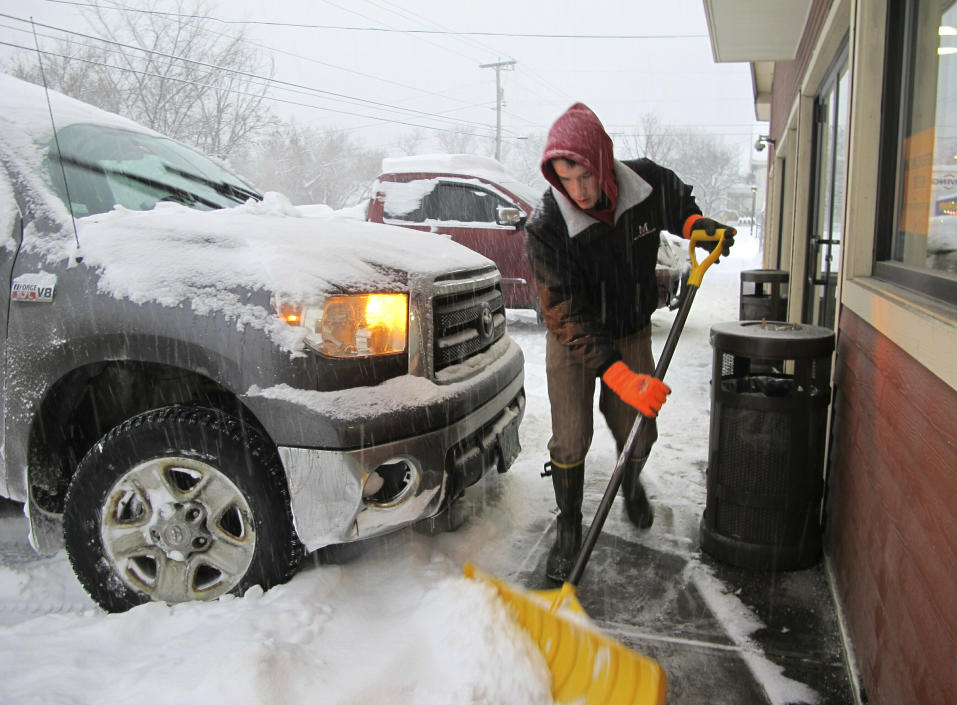
(AP Photo/Lisa Rathke)
Carter Martin shovels a sidewalk at Maplefields store and gas station on Sunday, Jan. 20, 2019, in Plainfield, Vt.
The snowstorm will be followed up by a blast of brutally cold air on Sunday night which could be dangerous for those left without power in the wake of the storm.
Download the free AccuWeather app to see how much snow you will receive in your area.

5:00 a.m. EST Sunday:
Rain, sleet and freezing rain continue to replace snow throughout the southern half of New England. After receiving 5 inches of snow, rain and sleet are now falling in Boston.
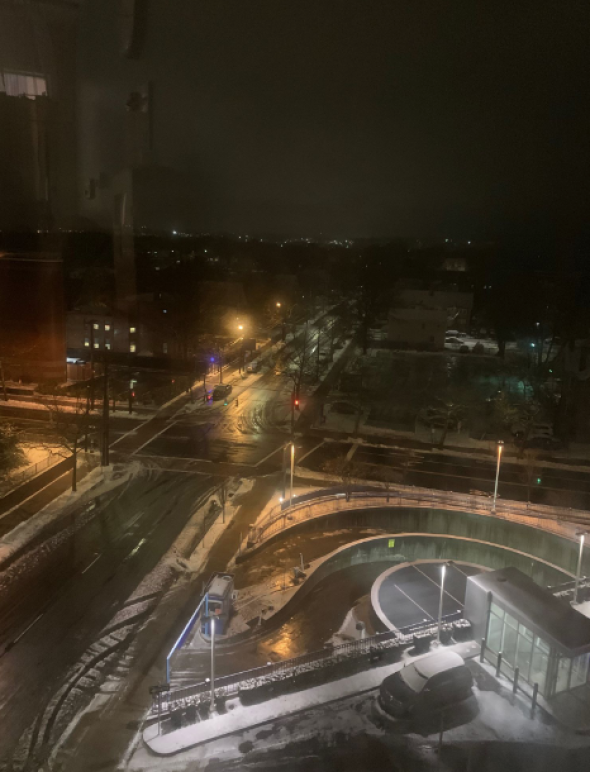
A view of York Street from Yale New Haven Hospital Emergency Department in New Haven, Connecticut at 5:00 a.m. on Jan. 20, 2019. Photo via Patricia Madrio
Following an inch or two of snow accumulation, rain is now inundating New Haven, Connecticut as temperatures rise into the mid 30s F. Road conditions are improving across the area as a result.
3:45 a.m. EST Sunday:
Level 3 Snow Emergencies have been declared for Hocking, Marion, Union, Delaware, Morrow, Crawford, Hardin, Putnam, Hancock, Seneca, Huron, Erie, Ottawa and Sandusky Counties in Ohio.
Freezing rain and sleet have replaced snowflakes over southern New England. While temperatures are expected to rise above freezing this morning, a flash freeze will result in more icy conditions by Sunday afternoon.
Everything is encased in ice here in Danbury, CT. I'm sure these conditions exist all along the I 84 corridor. Do not attempt to travel in these conditions! #NYwx #NJwx #CTwx #IceStorm
— NY NJ CT Weather (@nynjconnweather) January 20, 2019
Farther north in Albany, the airport has been reporting 1-2 inch per hour snowfall rates since midnight local time. So far 9 inches of snow have fallen, but over a foot of snow is expected to accumulate through Sunday afternoon.
Current scene in Saratoga Springs, NY. @NWSAlbany About to get a measuring stick and see how much has accumulated! 🥶😱 #NYwx #SnOMG pic.twitter.com/whDq6OzBip
— Kashawn Sinkler (@wxman_KPSinkler) January 20, 2019
12:50 a.m. EST Sunday:
Very heavy snow pummeling central and southwestern Ohio has prompted officials to declare Snow Emergencies for several counties.
Counties in a Level 3 Snow Emergency - the most severe option - include Morrow, Union, Licking and Pickaway Counties. This means all roads have been closed to non-emergency vehicles.
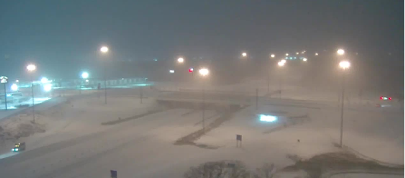
Traffic camera shot of Interstate 75 in Piqua, Ohio around 1:00 a.m. on Jan. 20, 2019
12:05 a.m. EST Sunday:
A band of very heavy snow is impacting the Cincinnati area, where there have been reports of thundersnow.
First time in my life hearing loud thunder in a snowstorm. Very heavy snow pounding #Cincinnati. #ThunderSnow @weatherchannel @breakingweather @accuweather pic.twitter.com/GJ15TXPpID
— Scott Ford (@ScottFordTVGuy) January 20, 2019
In New York City, rain is starting to mix with sleet and freezing rain. Road conditions are expected to deteriorate as a result.
In southeastern West Virginia, river flooding has overflowed onto roadways in Greenbrier and Summers counties. Local rainfall reports from this afternoon and evening show 0.75 to 1 inch of rain have fallen throughout the region.
A flood advisory is in effect for the area.
10:15 p.m. EST Saturday:
There are currently 11,324 customers without power in Indiana and 15,910 customers without power in Ohio, due to the storm.
Temperatures can drop significantly, so make sure to keep all doors to the outside shut. Use towels to block drafts coming in from window and door cracks.
Running a bathtub of hot water also draws in heat to the house. Turning faucets to a trickle helps prevent pipes from freezing.
8:50 p.m. EST Saturday:
Over the next few hours Buffalo, New York will see an increase in snow intensity. Heavy snow will continue overnight which will create very low visibility.
[8:50 PM UPDATE] Snow will increase in intensity through late evening, with heavy snow continuing overnight. The worst is yet to come, with deteriorating travel conditions over the next few hours. Blowing/drifting snow will continue in open areas with very low visibility. #nywx pic.twitter.com/GGz7t1RV6C
— NWS Buffalo (@NWSBUFFALO) January 20, 2019
7:00 p.m. EST Saturday:
Slick roads are leading to slow travel across the majority of the Northeast.
During echelon plowing, snowplows operate side-by-side across all lanes of a multi-lane highway to clear snow from several lanes at once. Snow from the lead plow is passed to the following plows until all lanes are cleared. It's extremely dangerous to pass between or around plows.
5:30 p.m. EST Saturday:
Governor Ned Lamont announced that he will partially activate the state's Emergency Operations Center (EOC) beginning at 6:00 p.m. local time this evening to monitor storm conditions across the state.
5:00 p.m. CST Saturday:
One lane on southbound Interstate 55 in Ste. Genevieve County, Missouri is now open. Crews hope to reopen all lanes within the next couple hours.
One lane of southbound I-55 in Ste. Genevieve County is now open. Both lanes are expect to reopen within the next couple hours. pic.twitter.com/29CeqGA90r
— MSHP Troop C (@MSHPTrooperC) January 19, 2019
4:30 p.m. EST Saturday:
A United Airlines plane skidded off the runway at O'Hare Airport today due to weather conditions.
O'Hare Airport also reported delays averaging 50 minutes and have canceled more than 650 flights.
Due to overnight snow & today's winds, airlines at ORD are reporting delays avg 50min and have cancelled 650+ flights. Crews are working hard to keep runways operational. Check flight status with carrier. (Video taken last night) pic.twitter.com/OJAapgxnv0
— O'Hare Intl. Airport (@fly2ohare) January 19, 2019
3:03 p.m. CST Saturday:
There have been multiple crashes on I-55 in Ste. Genevieve County, Missouri, which closed the interstate.
The roadway still remains closed at this time. Avoid this area if you are traveling.
Here are photos from a couple of the crashes that resulted in the closure of I-55 in Ste. Genevieve County. The roadway still remains closed at this time. Avoid this area if you are traveling. pic.twitter.com/zKFtxdt0es
— MSHP Troop C (@MSHPTrooperC) January 19, 2019
2:30 p.m. EST Saturday:
The commercial vehicle ban in Pennsylvania has been lifted from I-83, I-81 south of I-83, I-283, I-176, and the Turnpike from the New Jersey state line to the Carlisle exit.
#PAWinter Storm Update: At 2:30 p.m., the commercial vehicle ban was lifted from I-83, I-81 south of I-83, I-283, I-176, and the Turnpike from the New Jersey state line to the Carlisle exit. For full details → https://t.co/JbtAouDV73 CC: @GovernorTomWolf @ReadyPA @P_M_T_A pic.twitter.com/JoQxnWaSMg
— PA Department of Transportation (@PennDOTNews) January 19, 2019
2:00 p.m. CST Saturday:
As of midnight on Friday, Missouri troopers have received the following calls:
53 calls for service
15 calls for stranded motorists
7 calls for non-injury crashes
Troopers are out working crashes and assisting stranded motorists. They ask if you see them or any emergency personnel on the side of the road, please slow down. Roadways are slick and you can easily lose control, putting them and yourself in danger.
Roadways are covered in St. Francois County as the snow continues to fall. Roadways are extremely slick and dangerous for travel. Stay at home if at all possible. pic.twitter.com/qossJGlD0I
— MSHP Troop C (@MSHPTrooperC) January 19, 2019
1:45 p.m. CST Saturday:
According to Minnesota officials, snowplows are struggling to make progress on some roads due to cold and windy conditions. As temperatures continue to fall roadways can quickly become icy making for dangerous road conditions.
To stay safe and allow plows to do their jobs safely, officials are urging people to keep off the roads unless absolutely necessary.
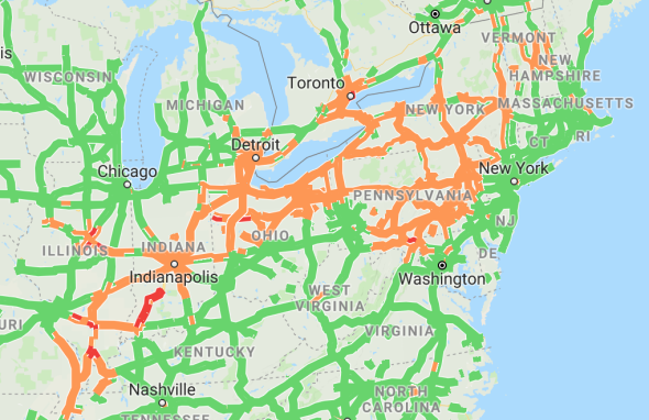
There are major traffic delays around Detroit, Michigan as well as Cleveland, Ohio.
12:30 p.m. CST Saturday:
New York Gov. Andrew Cuomo issued a tractor trailer and bus ban beginning at 3 p.m. EST on the entire thruway system and most highways in New York. Governor Cuomo added in his statement that the ban does not apply to I-95 in Westchester and Bronx counties.
10:30 a.m. CST Saturday:
Traffic disruptions have spread throughout Arkansas as a result of the snowfall. In Jefferson County and Pulaski County, multiple lanes were blocked and exits closed due to accidents and recovery efforts. At least five accidents have been reported since 5:00 a.m. CST Saturday.
Accidents have also been reported in New York, as the State Department of Transportation is advising residents to stay off roads.
Saturday 11:35 a.m. Accident on I-81 northbound just past I-690 East (Syracuse) right lane closed. Remember #nysdot advises staying off the roads if at all possible for the duration of the storm.
— NYSDOT (@NYSDOT) January 19, 2019
Flight cancellations have also racked up throughout the Midwest and Northeast.
Chicago O'Hare: 574 cancellations
Chicago Midway: 82 cancellations
John F Kennedy: 157 cancellations
LaGuardia: 41 cancellations
Toronto Pearson: 81 cancellations
Boston Logan: 168 cancellations
10:00 a.m. CST Saturday:
Isolated reports of power outages have emerged from Indianapolis and surrounding areas. The outages are being attributed to freezing rain.
In the Northeast, towns are preparing its residents to prepare for more outages and asking for help in reporting downed trees.
If you experience a power outage please contact @EversourceMA directly via 800-592-2000 or https://t.co/Mvsrr2WHMP
If you see a downed tree in the roadway or on a power line, contact @Hopkintonpolice at 508-497-3401. Or if you or somebody is in immediate danger - 911— Hopkinton, MA (@HopkintonMA) January 19, 2019
8:00 a.m. CST Saturday:
Numerous reports across the Midwest of accidents involving snowplows have been reported. In Minnesota, four snow plows were hit by other vehicles, according to the state's Department of Transportation.
In Kansas City, a snowplow driver was killed in a rollover accident. The tragedy closed the southbound lanes of 69 Highway at 199th Road.
"If you have to travel during the storm, make sure you give plows and emergency vehicles wide access," AccuWeather Senior Meteorologist Paul Walker said.
7:00 a.m. CST Saturday:
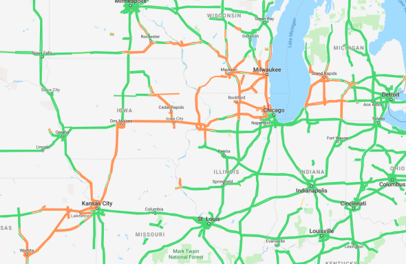
Updated snow totals across the Midwest:
9.2 inches near Swea City, Iowa
8.0 inches near Algonquin, Illinois
7.5 inches in Mundelein, Illinois
5.6 inches in Dubuque, Iowa
3.0 inches near Chicago's Midway Airport
5:50 a.m. CST Saturday:
Just over half of a foot of snow has reportedly accumulated in the northernmost reaches of Chicago. A couple more inches could fall before the snow tapers off later this morning.
Hazardous driving conditions out there this morning thanks to the heavy snow and gusty winds causing some drifting snow. Give yourself extra time to reach your destination if you need to travel this morning. https://t.co/8ddO5eK0m3
— NWS Milwaukee (@NWSMKX) January 19, 2019
At this time, flight cancellations total nearly 450 at O'Hare in Chicago; nearly 200 at New York's John F. Kennedy and LaGuardia; and over 150 at Boston Logan.
5:00 a.m. CST Saturday:
Snow has now overtaken much of the Lower Peninsula of Michigan, and has also started falling across the northern tier of Pennsylvania and Ohio.
Roads will quickly become slick at the onset of snow this morning across Ohio, Pennsylvania and New York.
Snow is starting to fall in parts of northern Ohio. As of 4:45am, we have 418 crews out on the road across the state. That number will continue to climb as the storm moves in. Please give our plows plenty of room to work. #ODOTwinter pic.twitter.com/SU5nmO962Y
— Ohio Dept of Transportation (@ODOT_Statewide) January 19, 2019
2:00 a.m. CST Saturday:
Snow showers are tapering off across the Des Moines area, where 5.1 inches of snow has accumulated. In far northeastern Iowa, a weather spotter has reportedly measured nearly 9 inches of new snow.
The "rain-snow line", where precipitation changes over from rain to snow, is very sharp across central Illinois. While it is currently snowing in Springfield, rain is falling less than 30 miles away in Taylorville.
Where this line sets up will determine where the highest snow accumulation totals are through the Midwest.
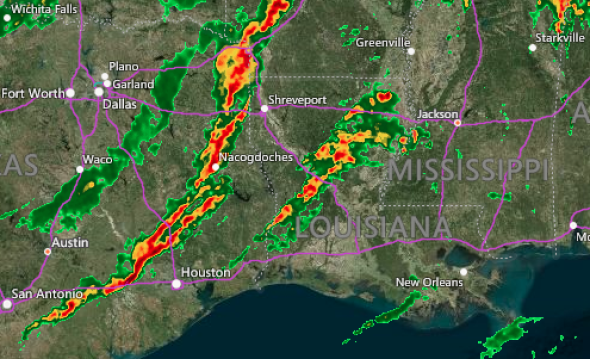
Farther south, this system is sparking lines of strong thunderstorms. Tornado-warned storms are firing across central Louisiana, while pea-sized hail has been observed in Arkansas.
12:18 a.m. CST Saturday:
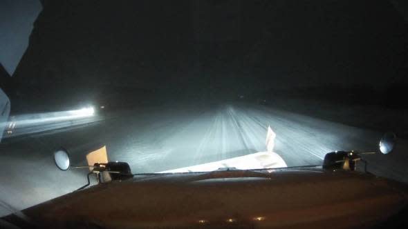
Heavy snow is currently pounding the Midwest, leading to slick roads and visibility of less than a mile across the region. Travel is slow and hazardous as a result.
Over 250 flights were canceled out of Chicago area airports on Friday. This trend is expected to continue on Saturday and extend to other major hubs such as Detroit, Philadelphia and New York on Saturday.
Snow is no stranger to Chicago and is expected to fall at O'Hare tonight. Our crews are standing by, ready to clear runways and keep airline operations running smoothly as possible. https://t.co/WKMHvwWaek
— O'Hare Intl. Airport (@fly2ohare) January 19, 2019
8 p.m. CST Friday:
A general 6-12 inches of snow have fallen from southwestern Wisconsin through eastern South Dakota as snow streaks across the region.
Many roads are covered in snow including Interstate 80 in Iowa.
A plow truck driving down a snow-covered stretch of Interstate 80 east of Des Moines, Iowa. (Photo/IowaDOT)
Snow will build into Chicago overnight with AccuWeather Meteorologists forecasting a storm total of 6-10 inches in the city by the time the snow ends on Saturday.
3:30 p.m CST Friday:
An airplane slid off the runway at Eppley Airfield in Omaha, Nebraska, forcing the airport to close for a time. No injuries have been reported, and crews are working to transport all passengers to the terminal.
Light, freezing drizzle and temperatures in the lower 20s F were reported at the airport around the time that the plane slid off the runway.
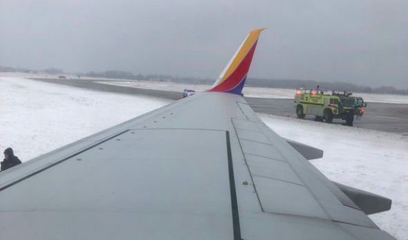
A photo from the ariplane that slid off the runway at Eppley Airfield early Friday afternoon. (Photo/Ali Schwanke)

