Residents, advocates decry proposed Kansas congressional maps as lawmakers advance GOP-authored proposal
- Oops!Something went wrong.Please try again later.
A Kansas Senate committee approved a Republican-introduced map that would make sweeping changes to the state's congressional districts Thursday, despite a stream of advocates and residents who slammed the redistricting proposal during public comment.
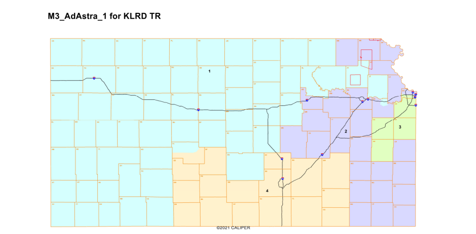
The map backed by House and Senate Republican leaders, dubbed "Ad Astra," would most controversially move part of Wyandotte County from the 3rd Congressional District into the 2nd Congressional District.
To balance out that switch, much of Lawrence, as well as Jackson and Jefferson counties, would leave the 2nd District and move into the 1st Congressional District, which runs to the Colorado border, encompassing much of western Kansas.
Lawmakers will have to split up one or both of Johnson and Wyandotte counties, which comprise the core of the current 3rd District. The current district layout has more individuals than is allowable, meaning changes will have to be made to the status quo.
The end product was less aggressive in targeting U.S. Rep. Sharice Davids, the state's lone Democrat in Congress, than many observers initially expected.
But the decision to divide Wyandotte County in half along Interstate 70 was a hotly contested one, as it would splinter off neighborhoods largely comprised of African American and Hispanic residents, while Johnson County was left intact.
Tom Witt, executive director of Equality Kansas, termed the map a "joke" and asked if it was an attempt "to troll" Democrats in the state.
"This is not serious and I am surprised leadership chose to introduce these maps," he said.
More: Proposed congressional district maps would have a big impact on Kansas voters. Here's what to know.
As Senate approves maps, critics slam rushed process, final product
Initially both chambers of the Legislature were set to hold hearings on the GOP-introduced map, as well as two proposed by Democrats.
But it was revealed the House would only hear testimony informally and would instead delay a more formal review of the maps because they were only introduced Tuesday.
Indeed, the accelerated timeframe frustrated those who testified. In-depth data from the maps were only made public Wednesday, after the deadline for submitting testimony had passed.
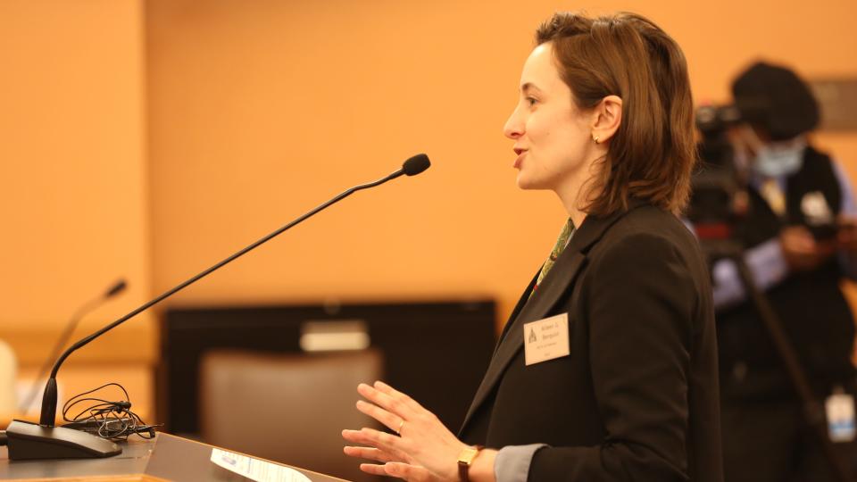
"This is redistricting and these are incredibly complex datasets," Aileen Berquist, community engagement manager for the ACLU of Kansas, said in her testimony. "So without those datasets, it's impossible to evaluate whether these maps are legal or constitutional. They might as well just be pretty pictures at this point."
The Senate Redistricting Committee ultimately approved the maps on a party-line-vote, but not before a spirited back-and-forth between lawmakers of both parties.
Democrats preferred their own plan, called "United," which would move the southwest part of Johnson County to the 2nd District but largely kept the status quo intact.
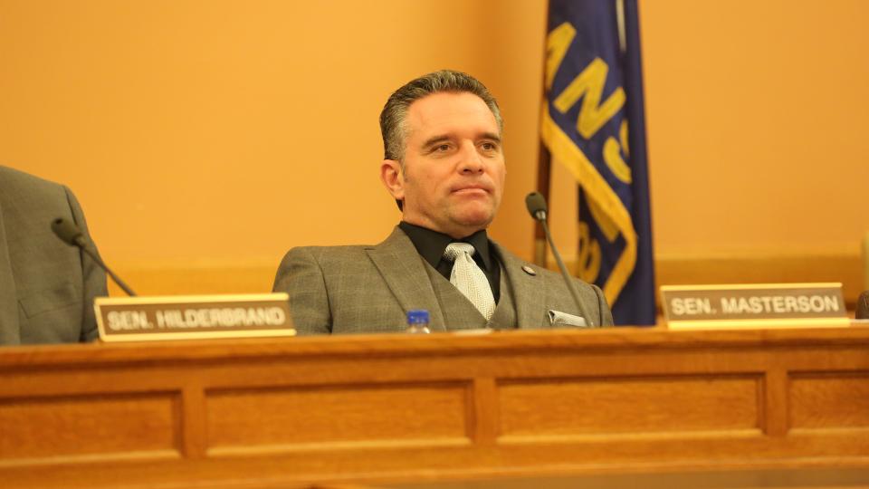
Senate President Ty Masterson, R-Andover, proposed an amendment from the earlier plan to ensure the Kansas Kickapoo Tribe's reservation not be split between two districts and instead be placed in the 2nd District.
But the bulk of the plan remained intact, despite concerns from Democrats.
"I think that we’re rushing this process," Sen. Ethan Corson, D-Fareway, said. "There may be a map between the Ad Astra map and the United map that can solve some of these (concerns), that is a middle ground and consensus map. What we are doing is a disservice to the state of Kansas."
That prompted a testy exchange with Masterson, who dubbed Corson's criticism of the maps to be political in nature.
"Numbers don’t lie, people lie about numbers," Masterson said.
More: In State of the State address, Gov. Laura Kelly lays out spending plan, acknowledges COVID surge
Advocates argue plan would harm Kansas City, Kan. residents
The vote came after residents lambasted lawmakers for crafting a map splitting Wyandotte County, arguing members of the public fiercely opposed such a move during a series of listening sessions held over the summer on the maps.
Residents pointed to a common argument, saying Wyandotte and Johnson counties are bound together by their status in the Kansas City, Mo. metropolitan area.
Connie Brown-Collins, of the Voter Rights Network of Wyandotte County, said residents routinely travel across county lines for work, errands and other business.
This makes them a clear community of interest, or a like-minded group bound together by a common force, she argued, saying more rural parts of the proposed district were radically different in their needs.
"We do not share a community of interest with Miami County," Brown-Collins said.
But Republicans said their biggest takeaway from public comment was that Johnson County should remain intact in one district, justifying the split.
"I can say that my constituents would like to stay," Sen. Beverly Gossage, R-Eudora, said.
The 3rd District currently has the lowest percentage of white residents of the four districts, largely due to the diversity of Wyandotte County. Under "Ad Astra," however, they would have the second-highest percentage of residents who are white.
Democrats and many Wyandotte County residents argued this would have the effect of watering down minority representation.
"It clearly will dilute the minority vote of the most diverse county in the state of Kansas," Mike Taylor, a lobbyist for Concerned Voters of Wyandotte County, said.
Masterson disagreed, saying the northern part of Wyandotte County was more similar to Shawnee County than Johnson County.
While it is true that Shawnee County has a larger population of Black and Hispanic residents than Johnson County, it is also much closer to Johnson demographically than Wyandotte County.
"I believe it actually does not affect dilution at all," Masterson said.
More: Gov. Laura Kelly, Republicans try to guide policy debate ahead of showdown in Kansas governor's race
Democrats threaten legal challenge to proposed maps
But Corson argued the way Wyandotte County was split posed a clear reason for courts to strike down the maps.
"This is not something where you can say that doing a wrong in the 3rd District is made up by ... doing a right in the 2nd District," he said.
Indeed, Democrats and their allies have already threatened a legal challenge to the maps, if enacted.
Republicans have largely framed these as idle threats, arguing there would have been a high likelihood of a legal challenge, no matter which maps were enacted.
But Patrick Miller, a professor of political science at the University of Kansas, said the decision to divide Wyandotte County would present a thornier set of legal issues than if Johnson had been split up.
Any arguments in state court will likely focus on how closely the maps adhere to guidelines laid out by the redistricting committees themselves — which include common racial and cultural interests.
"They have strengthen the hand of anybody who wants to go in the court and say they racially cracked Wyandotte County," Miller said. "You wouldn't have been able to say that had they broken up Johnson."
More: With $2.9 billion surplus, how will Kansas lawmakers spend your tax dollars or cut taxes this year?
To Miller, the current proposal is a much less aggressive attempt to kneecap Davids' Democratic seat than was expected.
His analysis of the district shows one that will continue to lean Democratic, with Johnson County undergoing a major political transformation — one which will continue to see the district turn bluer in coming years.
The district would still be competitive in 2022, when Davids squares off against Republican Amanda Atkins.
But keeping Johnson County intact, Miller said, will likely placate conservatives in the area who did not want to see the region divided, as well as opening the door for legislators from Johnson County who might want to run for Congress in the future.
"I think they actually picked ... maybe the politically safer map for them and balancing their own internal interests, but exposing them a little bit more on a legal level," Miller said.
Andrew Bahl is a senior statehouse reporter for the Topeka Capital-Journal. He can be reached at abahl@gannett.com or by phone at 443-979-6100.
This article originally appeared on Topeka Capital-Journal: Redistricting heats up, as advocates decry Kansas Congressional map

