Return of severe weather to rock the South


- Oops!Something went wrong.Please try again later.
Following the most recent rounds of tornadoes, damaging winds and large hail that occurred nearly two weeks ago, the South has had little in the way of severe weather. Unfortunately, AccuWeather forecasters expect that lull to come to an end.
The recent stretch of quiet weather continued into Thursday. By Friday, an increase in humidity levels will occur in the southern Plains as moisture is drawn northward from the Gulf of Mexico. Other factors will also contribute to the risk for thunderstorms as well.
"Warm, moist air will flow from the Gulf of Mexico and collide with a warm front pushing through the southern Plains," said AccuWeather Meteorologist Mary Gilbert. "This collision can have explosive results over portions of Texas, Oklahoma, Louisiana and Mississippi," she added.
 |
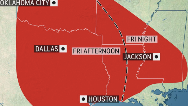
Thunderstorms are likely to develop near or just to the west of Interstate 35 Friday afternoon. This will place cities such as Oklahoma City and Dallas in the risk area.
"At this point, all manners of severe weather hazards look to be in play for Friday," stated Gilbert.
CLICK HERE FOR THE FREE ACCUWEATHER APP
As storms initially develop, individual thunderstorms will have the potential to rotate, and there will be a risk for isolated tornadoes. The threats will evolve as storms are likely to eventually become a more organized line.
"Damaging wind gusts, hail and downpours will be the most prevalent threats with any strong storm," Gilbert said.
The threat will continue to progress eastward Friday night, allowing severe thunderstorms to target other areas such as Houston and Jackson, Mississippi.
 |
Although the thunderstorms are expected to be fast-moving, rain may fall quickly and heavily enough to cause localized flooding. In the heaviest downpours, the AccuWeather Local StormMax™ of 8 inches could be achieved Friday into Saturday.
Those planning to travel Friday night must be extra cautious, as the depth of water is hard to gauge at night. Motorists should never cross a flooded roadway, day or night. When encountering a flooded area, turn around and find an alternate route.
"Those traveling at higher speeds across portions of interstates 10, 20 and 35 will need to reduce speeds during any downpours to prevent hydroplaning," Gilbert said.
She explained that while flash flooding most often strikes low-lying and poor drainage areas first, no area is truly exempt from the risks of heavy downpours.
 |
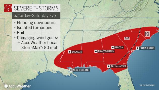
Thunderstorms will continue to move eastward Saturday. However, the areal coverage of severe weather is expected to be smaller than Friday and confined primarily to the Gulf Coast states. Areas from eastern Louisiana, southern Mississippi, southern Alabama, southern Georgia, the Florida Panhandle and into the Carolinas will be at risk for torrential downpours and gusty winds Saturday. This would include cities such as New Orleans and Baton Rouge, Louisiana; Montgomery and Mobile, Alabama; Columbus, Georgia; and Columbia, South Carolina.
The storms are not likely to reach coastal areas of Georgia and the Carolinas until Saturday evening.
The cold front will largely be offshore by Sunday, but a few thunderstorms may become locally gusty in central and southern Florida.
AccuWeather meteorologists are watching for another round of severe weather early next week as a potent storm takes shape over northern Texas and tracks east. The storm's cold front will trigger the threat for torrential downpours, potentially damaging wind gusts - and moisture from the Gulf of Mexico will add fuel to the thunderstorms that ignite. Locations from central Texas to eastern Kansas should be on alert as this is the corridor where AccuWeather meteorologists expect a potential severe weather outbreak to occur.
As the next system tracks farther to the east by the middle of next week, the threat for severe weather will increase over the Mississippi Valley and northwestern Gulf coast area.
Many residents in the South recall "the spring of 2011 as one of the most active springs in recorded history for severe weather, especially April with over 700 tornadoes, but it was a later start to that tornado season," Extreme Meteorologist Reed Timmer said.
Similar to 2011, the start to severe weather season has been slow to develop across the United States with AccuWeather meteorologists expecting spring severe weather to turn more active in the coming weeks.
Only 34 tornadoes touched down in the U.S. since April 1 as of April 20, according to the Storm Prediction Center (SPC). On average, 224 tornadoes occur during April in the U.S.
AccuWeather forecasters say the latest data is pointing toward April closing with a below-average number of tornadoes. But, AccuWeather Lead Long-Range Forecaster Paul Pastelok predicted that as the calendar flips to May severe weather will ramp up.
The number of severe thunderstorms can drastically increase during the months of May and June, which can also lead to an increase in the number of tornadoes that develop. AccuWeather meteorologists are predicting between 250 to 325 tornadoes will occur during the month of May. On average, 269 tornadoes occur during May in the U.S.
Keep checking back on AccuWeather.com and stay tuned to the AccuWeather Network on DirecTV, Frontier, Spectrum, FuboTV, Philo, and Verizon Fios.
