Rhode Island has a lot of villages and they can be confusing. We try to answer why
How many villages do you think there are in Rhode Island?
There are 39 cities and towns. According to RI.gov, the state's land area is 1,045 square miles, just to give you a little perspective as you ponder the question.
The answer, according to Roberta Mudge Humble, a former English professor at the Community College of Rhode Island who’s written Rhode Island trivia books and games, is more than 400. Roughly speaking — and this is not perfect math — that’s one village for every 2½ square miles in the state, though not everywhere is part of a village.
And these villages are fiddly to track. Some are very clear, but others can cross town lines, be a village within a village or just have vaguely drawn boundaries.
This became abundantly clear when a What and Why RI reader wrote in asking what are the accepted boundaries of Cowesett?
Where is Cowesett and what are the boundaries?
Cowesett is a village in Warwick, and it’s a fraction of the original Cowesett Farms, which were laid out and allotted to purchasers in Warwick in 1684.
Cowesett, it’s worth noting, was also the name of a small family of Native Americans who lived in Rhode Island, according to The History of the State of Rhode Island and Providence Plantations, Volume 3.
Warwick City Hall provided a map that outlined the boundaries in thick lines. While it’s helpful, the city engineer, Eric Hindinger, sent an accompanying note that he would like to emphasize “these boundaries are not official in any way, they were taken from a map that was drawn in 1999.”
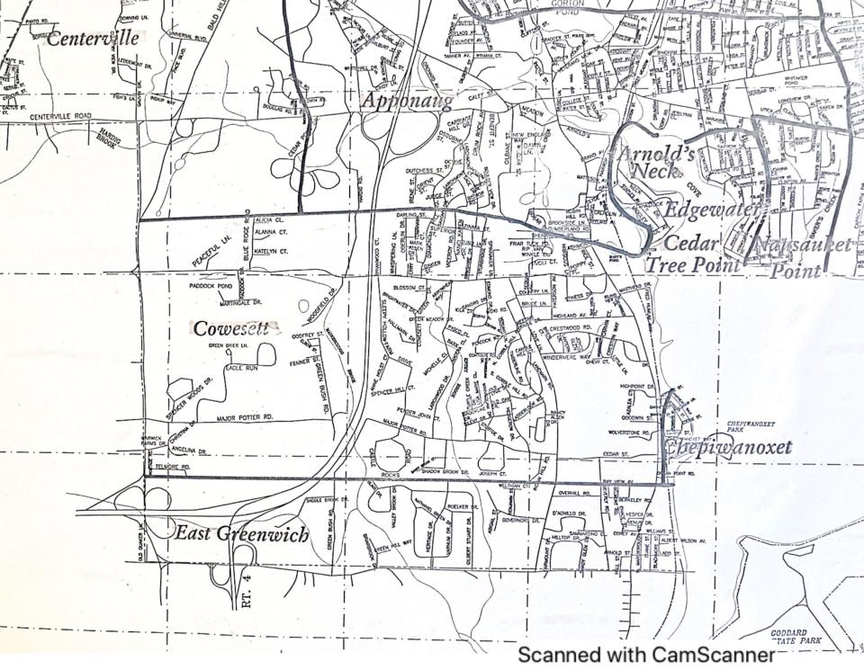
But between that caveat, and the fact that many businesses outside of that footprint use Cowesett as part of their name (Cowesett Plaza and Cowesett Gardens in West Warwick being obvious examples), The Providence Journal did a little more digging beyond the map.
The Pawtuxet Valley Preservation & Historical Society confirmed in an email that there is no village of Cowesett in West Warwick.
And a look at the website of the East Greenwich/Cowesett Neighbors Club, which has been around since the 1970s, gave the clearest definition of the Cowesett boundaries, defining it “as the area bounded by Division Street on the south, Cowesett Road on the north, Interstate 95 on the west, and Narragansett Bay on the east.”
What and Why RI: How did Federal Hill get its name? There was almost bloodshed.
Other areas likely use the name because of the connection to Cowesett Farms, which did cover some of the area that is now West Warwick, according to a 1987 town report.
Why are Rhode Island village boundaries hard to pin down?
It’s not uncommon for village boundaries to be hard to trace.
“Towns have boundaries drawn, villages,” Humble said with a pause, “they don’t have to be incorporated.”
What and Why RI: The Awful Awful is a classic Rhode Island treat. Here's how it got its name.
Because they don’t involve the same level of paperwork, Humble said the villages are often harder to track down. They tended to spring up in response to a business moving into a community, or around ethnicities.
“Neighborhoods grow to villages,” she said.
She also pointed out that villages can cross town lines, or there can be a village within a village. For example, Usquepaug is a village in West Kingston, and West Kingston is a village within South Kingstown, and it has an arm in Richmond. It won’t be contained.
What and Why RI is a weekly feature by The Providence Journal to explore our readers' curiosity. If you have a question about Rhode Island, big or small, email it to klandeck@gannett.com. She loves a good question.
This article originally appeared on The Providence Journal: RI has many villages that are difficult to map. Here's why

