Rinse and repeat: stormy pattern to linger in the Northwest

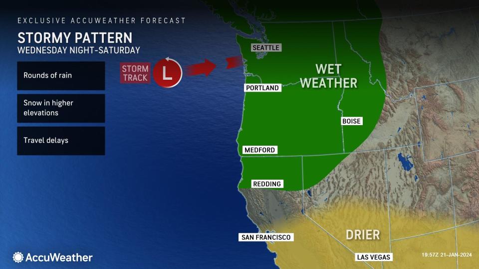

AccuWeather meteorologists say that the damp, active pattern along the West Coast ushering rounds of rain will persist through Monday night. However, a stretch of dry weather may be on the horizon later this week for portions of Central and Southern California.
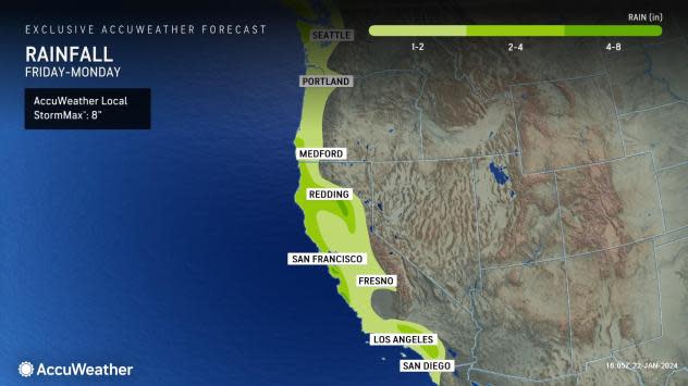
A storm tracking into the West Coast will continue to bring soaking rain to locations from Washington to California through Monday night. Additional rainfall totals could range between 1-2.5 inches in some areas along the central and northern coasts. In the foothill areas to the south of Klamath National Forest, Shasta-Trinity National Forest and Lassen National Forest could contend with locally higher amounts of 3-4 inches from this latest storm.
Farther south, across a large part of Southern California, steadier rain is in store. Some of that rain may fall at a heavy enough rate to lead to urban flooding. Downtown Los Angeles observed 0.41 of an inch of rain on Saturday, Jan. 20, and a trace of rain on Sunday, Jan. 21. On Monday, 1.28 inches of rain fell.
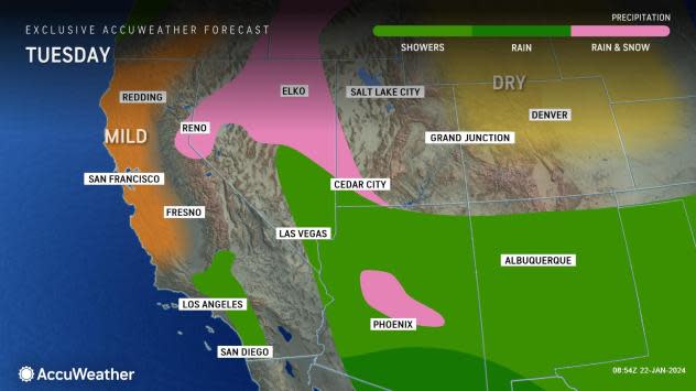
"Dry weather returns across most of the state on Tuesday, then another piece of energy will move into the Northwest that can bring showers to Northern and Central California again," added AccuWeather Meteorologist Haley Taylor.
 |
Localized roadway flooding will continue to be a concern through Monday night as this band of rain tracks through the City of Angels. Nearby mountain locations can pick up even more rain, with localized totals upwards of 2-3 inches. Along the coast, there can even be a few rumbles of thunder.
Coastal flood advisories and beach hazard statements were put in place through the end of the weekend, warning of strong rip currents, high surf, localized beach erosion and flooded roads along the coast.
Have the app? Unlock AccuWeather Alerts™ with Premium+
 |
As the storm pushes inland Tuesday, rain will begin to overspread towns in Utah, Arizona and New Mexico. Cooler air lingering in the parts of northern Arizona, south-central Utah, and western Colorado will allow for occasional snow showers in the highest elevations. Snow levels across the region will generally remain above 6,500 feet.
Falling temperatures in Flagstaff, Arizona, as the storm moves through the region, will allow for snow showers at times through Tuesday morning. Daytime highs will stay mainly in the 30s through early week with overnight lows below the freezing mark. Snowfall totals are projected to range between 1-3 inches early this week in Flagstaff, with the chance for 6 inches in the highest levels above 7,500 feet.
By Tuesday, a zone of high pressure will push into the Southwest coast and promote drier conditions for many California and western Nevada residents. Meanwhile, a separate storm will begin barreling into the Northwest with additional coastal rain and snow in the mountains.
The late-week pattern across the West will favor drier conditions to the South and continued damp and dreary weather to the north. Cities like San Francisco and Los Angeles could experience a stretch of dry weather from late week into early next week, potentially longer if the pattern of high pressure persists.
 |
On Sunday, Jan. 28, the San Francisco 49ers will take on the Detroit Lions in their home field, Levi's Stadium, in Santa Clara, California.
Forecasters looking ahead to the conditions say that the pattern is favoring generally dry conditions for Sunday, Jan. 28, in the Santa Clara area.
"High pressure in place will help to hold off any showers on Sunday for the upcoming San Francisco playoff game, conditions look to remain mainly dry from late week onward into the upcoming weekend," noted Taylor.
Temperatures can range in the upper 60s F on Sunday, Jan. 28, by the early afternoon hours, but then can fall into the middle to lower 60s by kickoff time at 6:30 p.m. ET (3:30 p.m. local time).
Want next-level safety, ad-free? Unlock advanced, hyperlocal severe weather alerts when you subscribe to Premium+ on the AccuWeather app. AccuWeather Alerts™ are prompted by our expert meteorologists who monitor and analyze dangerous weather risks 24/7 to keep you and your family safer.
