Weather: Rough seas, dangerous rip currents, cooler temperatures ahead of Thursday storms
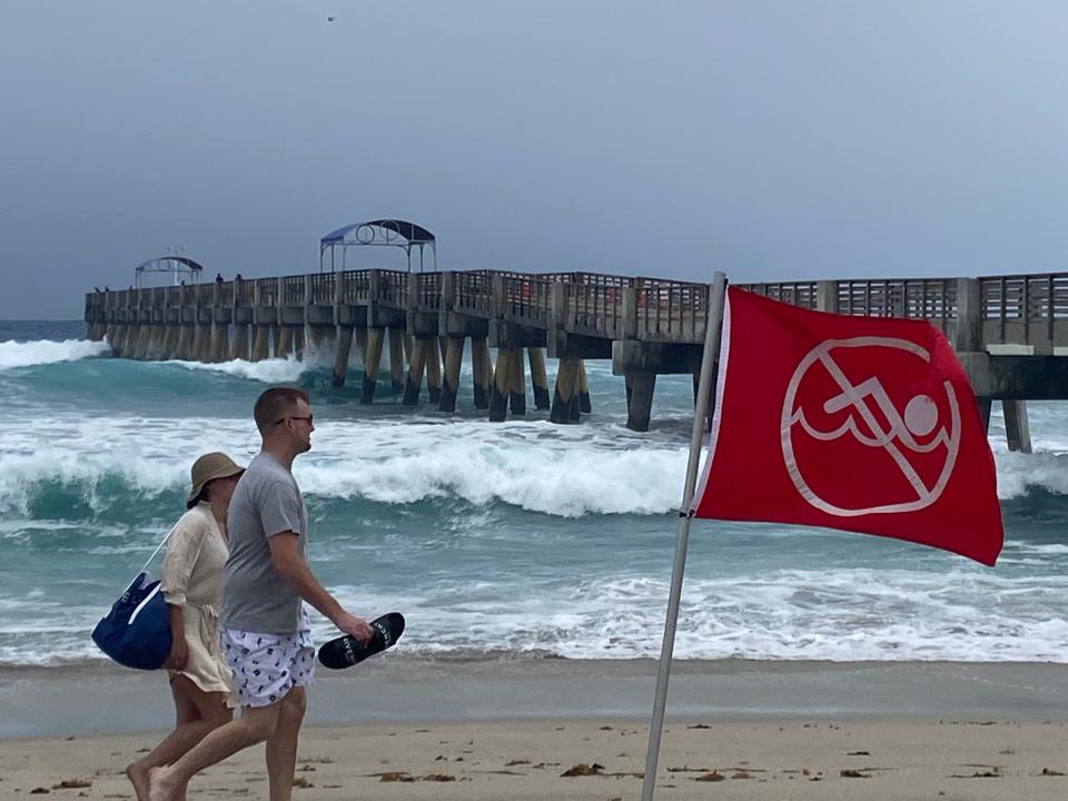
Palm Beach County's beaches Wednesday were reserved only for experienced surfers, shell collectors, kite surfers and bicycle riders along A1A, thanks to high seas and brisk winds.
Red flags warning of rip currents flapped in the 15-20 mph north winds on Palm Beach, just north of the clock tower at Worth Avenue. Waves of about 5 feet were breaking on the mostly deserted beach that was dotted with surfers.
"By far the most pressing issue in Palm Beach County the next few days is the hazardous beach and marine conditions," according to Sammy Hadi, a meteorologist with the National Weather Service in Miami.
More: What to know about rip currents and how to survive if you get caught in one
More: One person dies, six taken to hospital after rip current incident off Palm Beach
Rip currents can sweep even the strongest swimmers away from the coast to deeper waters. They are strong, narrow currents that flow away from the beach, developing any time with strong, breaking waves.
Craig Pollard, lifeguard supervisor for the town of Palm Beach, said the ocean Wednesday was only for strong swimmers in guarded areas.
“If you are in water up to your waist, that current can easily sweep you away," said Pollard, who has been a lifeguard for 33 years. "You are in danger of colliding with jetties and rock piles."
Still, some people, despite flags and precautions, are determined to go swimming.
“We tell them they could die. We explain the dangers. Most people use their common sense and we do not have a problem,” said Pollard.
For Palm Beach County, the most dangerous conditions exist as a high surf advisory remains in effect until 8 p.m. Thursday and a high rip current risk remains in effect through Friday morning.
Surf advisories can be listed as low, moderate and high.
In Palm Beach County, large waves were breaking at 5 to 9 feet in the surf zone. That's great for surfers, but not so great for swimmers.
Dripping wet from surfing, Virginia resident Parker Sawyer said it’s not often waves off Palm Beach are this good.
“It’s windy, but it’s really good for surfing. The waves are choppy, but it’s still great surf,” said Sawyer, 24, who works at a surf camp in Virginia.
Another surfer, who had just finished a run closer to the Palm Beach clock tower, was loading his board into his truck. Mark Norteen’s friends had just called and said the waves were better in Jupiter, about a mile north of the Juno Beach Pier.
“They got their kite boards out and said the waves are 8-10 feet. Should be fun,” said Norteen, 22, a Boynton Beach landscaper.
Those high surf conditions and rip currents are a product of a low pressure system in the western Atlantic Ocean pushed southwest by a big ridge of high pressure, Hadi said.
The winter and spring is peak season for rip currents because of the strong east flow of the winds off the Atlantic Ocean. And unlike a tornado, rip currents "are subtle but just as deadly," Hadi said.
This year, five people have been killed by surf zone fatalities, including a 47-year-old Palm Beach County man who was caught in a rip current after he had gone into the waters off Palm Beach. There have been eight fatalities from tornadoes in 2022.
"When you have those big waves that crash on shore and the weather is beautiful, you still have to be very careful," Hadi said. "There are optimal conditions for rip currents. Those currents are strong and will suck you right out."
Hadi said high surf advisories will remain for the next few days and possibly even into the weekend.
"It takes awhile for the ocean to settle down," he said. "I'd be very careful going into the water the next few days."
Thursday weather forecast: Some rain, higher temperatures
That same low pressure system that is being pushed eastward will produce some rain for the next few days, including an isolated thunderstorm.
"It's not going to be a total washout," Hadi promised. "But more moisture, humidity and higher temperatures will move into the area for the next few days."
Some of the storms could be strong with higher rain chances midday and in the early afternoon. Highs will be in the mid-upper 80s.
The low pressure system, even with circular churning winds, is non-tropical, Hadi said, because it has a front attached to it. A tropical system shows significant low pressure with winds that are feeding off of the warm ocean waters.
Scientifically, the pressure gradient (the difference between a high and low pressure area) helps determine whether the system is considered tropical. For tropical systems, the stronger the pressure gradient is, the greater the wind speeds are.
In the case of this system, it is not a significant pressure difference.
Still, the system will produce higher winds, seas and some rain although much of the activity will remain offshore.
Hadi said the strong surf will likely cause some coastal erosion on Palm Beach County beaches.
Palm Beach County has spent millions of dollars in recent decades replacing beach sand scraped away from the relentless ocean.
Why has the temperature been unseasonably cool the past few days?
The nice cooler evening temperatures will disappear as the low pressure system makes its way toward the coast.
Those pleasant conditions were a product of dry, cool air from the continental United States that worked its way down the peninsula. Combined with the clear skies, it created ideal conditions, especially for shell enthusiasts.
On Lake Worth Beach, many beachgoers enjoyed watching the waves crash onto the north side of the William O. Lockhart Municipal Pier. Others walked along the shore, looking for shells hauled in from the powerful waves.
“Big waves and dredging. That’s when we come come here to find the best shells,” said Frank Bartola, 64, a Long Island resident.
For the weekend and early next week, hot and humid weather returns with highs climbing into the upper 80s.
Weekend weather forecast for West Palm Beach
Thursday: Showers and some isolated thunderstorms with a 52% chance of rain. High 82, Low 69.
Friday: Afternoon showers with a 34% chance of rain. High 86. Low 71.
Saturday: Afternoon showers with a 48% chance of rain. High 87. Low 73.
Sunday: Afternoon showers with a 37% chance of rain. High 88. Low 73.
What should you do if you are caught in a rip current
If you do go in the water, make sure you are near a lifeguard.
If you're caught, relax and float. Don't try to swim against a strong current.
Face the shore and call or wave for help.
If you can, swim in a direction parallel to the shoreline.
Palm Beach Post correspondent Bill DiPaolo contributed to this report.
James Coleman is a journalist at the Palm Beach Post, part of the USA TODAY Florida Network. You can reach him at jcoleman@pbpost.com. Help support our journalism. Subscribe today.
This article originally appeared on Palm Beach Post: West Palm Beach weather: Rip currents, rough seas, Thursday storms

