Next storm to set its sights on US West Coast by midweek
As cleanup continues from this past weekend's storms, a new round of rain, mountain snow and gusty winds will take aim at the West Coast of the United States into Wednesday.
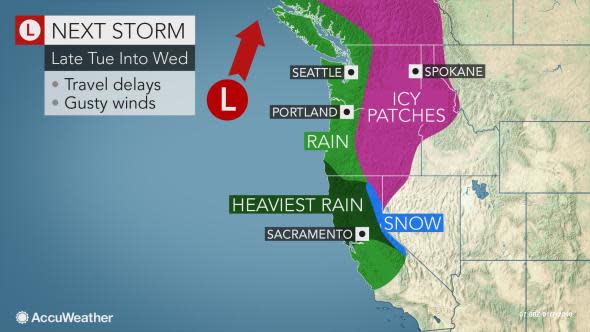
Northern California will again bear the brunt of the rainfall with this storm from Tuesday night into Wednesday. Lighter rain will dampen areas farther north, including Portland, Oregon; and Seattle.
Similar to what occurred late Sunday in the Bay Area, motorists will again need to be on alert for high water on the roadways.
Motorists are reminded to never attempt to drive through floodwaters or around barriers. It is impossible to tell how deep the water is and if the roadway underneath has been compromised.
The risk of flash flooding and mudslides may be greatest with this storm, as the ground is already saturated and the hillsides in recent burn areas are likely to be unstable, according to AccuWeather Senior Meteorologist Alex Sosnowski.
"People should heed all evacuation orders for their area, if given, as there may only be minutes to move to safety," Sosnowski added.
Gusty winds will again whip along the coast and in the mountains, potentially leading to more damage in communities that were hit hard over the weekend.
Even though winds are not expected to be as strong as they were over the weekend, it does not take as high of a wind gust to topple trees and power lines when the ground is saturated.
Another round of snowy, treacherous travel is in store for the mountains.
"Any rain at the storm's onset should quickly change to snow and treacherous travel at Donner Summit," Sosnowski said.
Travelers over this stretch of Interstate 80 will need to make sure their vehicles are properly equipped to drive in such conditions.
Slick travel may not be confined to the typical mountain passes.
"There can be enough lingering cold air for snow or ice in some of the interior valleys of the Northwest with the midweek storm," said AccuWeather Senior Meteorologist Kristina Pydynowski.
While any snow or ice will tend to be spotty east of the Cascades, motorists should use caution across central and eastern Oregon, Washington and the Idaho Panhandle late Tuesday into Wednesday.
Areas of the roadway that appear wet may be coated with a thin layer of ice, known as black ice.
Download the free AccuWeather app to know exactly how the storm will impact your area.
People with travel plans late in the week will be glad to hear that mainly dry weather is expected late Thursday into Friday.
However, another dose of rain and mountain snow is expected to roll in Friday night to Saturday.
"That storm may bring soaking rain and a risk of mudslides to parts of Southern California as well as Northern California," Sosnowski said.
Oregon and Washington should be spared from any impact from this storm.

