Saharan dust clouds reached Florida and the Atlantic coast. How does it affect weather?
Noticing hazy skies in Florida?
That could be dust carried from Africa's Sahara Desert, making it all the way to the Southeast states.
The movement of dry air filled with Saharan dust happens yearly, often reaching the U.S. just before the Atlantic hurricane season. Last year, the dust clouds were predicted to be seen in Florida by mid-June.
Along with air pollution, other possible health hazards include eye, ear, nose and throat irritations.
Palm Beach weather: Storms, heat, Saharan dust could be on tap for weekend
NASA research split: Will Florida see more or less of these yearly storms?
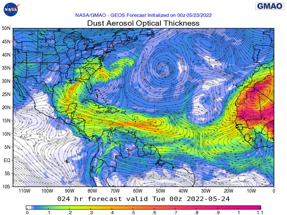
See Monday's dust forecast below from NASA and the Global Modeling and Assimilation Office (GMAO), an organization that uses computer models and data assimilation techniques to enhance NASA’s program of Earth Observations.
What is Saharan dust?
Also called the Saharan Air Layer (SAL) by the National Oceanic and Atmospheric Administration, Saharan dust is a mass of very dry, dusty air that forms over the Sahara Desert during the late spring, summer and early fall.
Its dust clouds can travel and impact locations around the globe, thousands of miles away from its African origins. The warmth, dryness and strong winds associated with the dust clouds have been shown to suppress tropical cyclones.
"SAL activity typically ramps up in mid-June and peaks from late June to mid-August, with new outbreaks occurring every three to five days," Principal Investigator Dr. Jason Dunion, a University of Miami hurricane researcher, said.
"During this peak period, it is common for individual SAL outbreaks to reach farther to the west — as far west as Florida, Central America and even Texas — and cover extensive areas of the Atlantic."
How does the SAL influence weather and climate?
According to the National Weather Service, there are three characteristics of these Saharan dust outbreaks that can affect tropical cyclones, tropical disturbances, and the general climatology of the Atlantic tropical atmosphere:
Extremely Dry Air: The Saharan Air Layer’s dry, dusty air has about 50% less moisture than the typical tropical atmosphere. This extremely dry air can weaken a tropical cyclone or tropical disturbance by promoting downdrafts around the storm.
African Easterly Jet: Strong winds in the Saharan Air Layer (25-55 mph or 10-25 meters per second) can substantially increase the vertical wind shear in and around the storm environment. This “mid-level jet” of enhanced winds, typically found at a height of 6,500-14,500 feet (2000-4500 meters), can cause tilting of the tropical cyclone vortex with height and can disrupt the storm’s internal heat engine.
Warm Temperatures: The Saharan Air Layer’s warmth acts to stabilize the atmosphere, which can suppress the formation of clouds. This stabilizing effect is produced when the Saharan Air Layer’s warm, buoyant air rides above relatively cooler, denser air. The Saharan Air Layer’s suspended mineral dust also absorbs sunlight, which helps maintain its warmth as it crosses the Atlantic Ocean.
Saharan dust has vibrant sunsets
In short terms... Because of the special way Saharan dust scatters sunlight, the best times of day to spot it are usually a few hours after sunrise and in the late afternoon, according to the SAL website. During the day, the sky will have a hazy white look and sunsets will take on an orange glow.
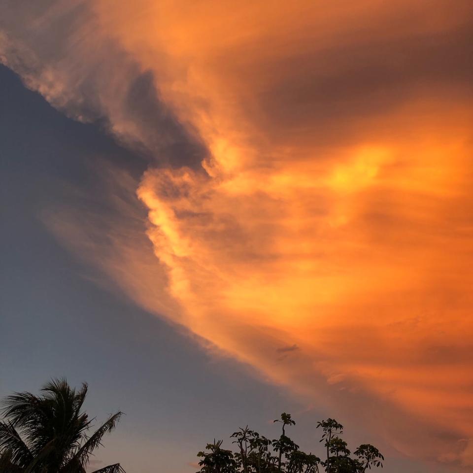
In long terms... The sun's white light is composed of all the colors of the rainbow. Our skies are normally blue because the gases that make up the atmosphere naturally scatter blue hues (shorter wavelengths) as opposed to the yellow-orange-red hues (longer wavelengths). Sunsets and sunrises take on more yellow and reddish hues because the low-angle sunlight passes through more of the atmosphere before it reaches your eyes. A heavy load of dust in the atmosphere can enhance this effect, leading to longer-lasting, duskier colors that cause vivid sunsets and sunrises.
Saharan dust map today
From Broward County's Natural Resource Division:
"Good morning! The #AirQuality forecast for #BrowardCounty on Monday, May 23rd is MODERATE. This is due to Saharan dust and is not uncommon during this time of year. Thanks to @NASA for the map below that allows us to visualize this more easily!"
Good morning! The #AirQuality forecast for #BrowardCounty on Monday, May 23rd is MODERATE 🟨. This is due to Saharan dust and is not uncommon during this time of year.
Thanks to @NASA for the map below that allows us to visualize this more easily! pic.twitter.com/gLRBfjZARJ— Broward County Environment (@BrowardEnv) May 23, 2022
South Florida:
Over the weekend, WPLG Local 10 meteorologist Brandon Orr (Miami) tweeted:
"Our first burst of Saharan dust of the season has made it to South Florida."
Our first burst of Saharan dust of the season has made it to South Florida. The sky will look unusually hazy and gray today with lower rain chances. #FLwx pic.twitter.com/xfdDvzGb69
— Brandon Orr (@BrandonOrrWPLG) May 21, 2022
Grace Pateras is a digital producer for the USA TODAY Network. Follow her on Twitter at @gracepateras.
This article originally appeared on Palm Beach Post: Saharan dust clouds reach Florida and the Atlantic Coast. What is it?

