Oregon wildfires: Level 3 Go Now orders still in effect for Bedrock, Lookout fires
The latest Oregon wildfires roundup is posted here.
This story was updated at 5:45 p.m. Monday, Aug. 14.
A heatwave with a high chance of temperatures exceeding 100 degrees is expected to hit the Willamette Valley and other parts of Oregon continuing through at least Wednesday.
Here are the latest on wildfires and heat news across Oregon.
5:30 p.m. Monday: Evacuation point set up
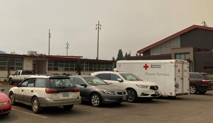
A Temporary Evacuation Point has been set up at McKenzie High School, 51187 Blue River Drive in Vida. It will be open Monday until 8 p.m.
It is not an overnight shelter, but residents can meet with representatives from Red Cross, the Oregon State Fire Marshal's Office, the fire management team, and Lane County.
4 p.m. Monday: Informational Facebook pages
The Lane County Sheriff's Office and Lane County Emergency Management have created new Facebook pages to help residents track information related to the Bedrock and Lookout fires.
The pages will provide up-to-date evacuation information, shelter information, animal evacuation information and other resources.
Find the Facebook pages at:
2 p.m. Monday: Where to take evacuating livestock
Lane County residents under a Level 2 Be Set or Level 3 Go Now evacuation notice are encouraged to move large animals and pets out of the evacuation area.
Large animals and livestock can be taken to the Lane Events Center, 796 W. 13th Ave. in Eugene.
Owners must call or text Lane County Animal Services at 541-285-8227 before arriving at the center. Leave a detailed message, including the number and type of animals, if your call is missed.
Owners can also call 541-285-8227 if they need help evacuating their animals or need to arrange for shelter-in-place feeding because the animals can't be moved.
1:30 p.m. Monday: Air quality issues
The Oregon Department of Environmental Quality has extended an air quality advisory for eastern Lane County through Tuesday evening due to wildfire smoke.
The smoke could impact the Eugene and Springfield areas, officials said.
Air pollution levels were measuring “unhealthy” in Sweet Home as of 9 a.m. Monday. Monitors in other areas of the county were reading at “moderate.”
Oregon ranks air quality as good, moderate, unhealthy for sensitive groups, unhealthy, very unhealthy or hazardous.
Sensitive groups include children, people over 65, pregnant people and people with heart disease or respiratory conditions. Health officials recommend those groups limit outdoor activities when pollution levels are high.
Current air quality conditions and advisories can be found on DEQ’s Air Quality Index at ordeq.org/oregonair or by downloading the free OregonAIR app on a smartphone.
12:30 p.m. Monday: A dozen evacuees at Lowell High School
Red Cross worker Linnet O'Hanlon said a dozen evacuees from the Bedrock and Lookout wildfires have checked in at a shelter at Lowell High School.
O'Hanlon said the Red Cross is providing immediate needs like food and refrigeration for medicine.
A regional Red Cross team is expected to take over shelter management by Tuesday and will offer “spiritual care, mental health professionals to help people," she said. "It’s good to be here and help people out.”
8:55 a.m. Monday: Level 3, Level 2 orders issued near Fall Creek for Bedrock Fire
The following areas are being upgraded to a Level 3 Go Now evacuation notice by Lane County Sheriff's Office due to the Bedrock Fire:
Peninsula Road east of Timber Creek.
Big Fall Creek Road east of the intersection with Peninsula Road.
Level 3 means leave immediately. Do not take time to gather things. There is immediate and imminent danger.
A Level 2 Be Set notice was issued Monday morning for the following areas:
Big Fall Creek Road east of Winberry Creek Road east of Winberry Creek Road to Peninsula Road.
Peninsula Road along the south of Fall Creek Reservoir to Timber Creek.
Winberry Creek Road east of milepost 4.0.
Level 2 means residents must prepare to leave at a moment's notice and this may be the only notice they receive.
The Red Cross has opened a shelter for people and small, domestic pets at Lowell High School, 65 Pioneer St.
Residents on a Level 2 or Level 3 order who need help with large animal sheltering can call Lane County Animal Services at 541-285-8227.
Residents are encouraged to sign up for emergency alerts at lanealerts.org
10 p.m. Sunday: Level 3 Go Now order issued for Lookout Fire
A level 3 Go Now evacuation order was issued Sunday night in Lane County for:
Taylor Road.
North Bank Road.
All areas north of Highway 126 between Blue River Reservoir Road and Drury Lane.
Mona Campground.
Lookout Campground.
HJ Andrews Experimental Forest headquarters.
This level means residents should leave immediately and there is extreme danger. Emergency responders may not be able to help you if you stay. Do not stop to gather belongings or protect your home. Leave as fast as safely possible.
A Level 1 Be Ready order is in effect for residents:
Areas south of Highway 126 from Blue River Reservoir Road east to Foley Ridge Road.
McKenzie River Drive.
An interactive map that allows for an address search is available online. An assembly point is set up at McKenzie High School, 51187 Blue River Drive. A shelter would be established if a Level 3 Go Now order is issued.
An emergency closure order was issued late Friday night and went into effect immediately. The closed area includes Frissell North Trailhead, Lookout Creek Trailhead, Carpenter Mountain Trailhead, Lookout Creek Trailhead #4105, Carpenter Mountain Trail #3302, and a part of Frissell Trail #3512.
Lane County officials are providing updated evacuation information at lanecounty.org/lookoutfire. Residents are encouraged to sign up for emergency alerts at lanealerts.org
Salem issues burn ban; area between Salem and Eugene of 'high concern' for fire danger
The city of Salem announced a burn ban on all outdoor burning. This includes agricultural burning, recreational fires, land clearing and ceremonial fires. The ban will last until further notice. More information can be found on the city's website.
Multiple red flag warnings were issued Saturday afternoon by the National Weather Service across the state:
Fire Weather Zone 603 East Slopes of the Central Oregon Coast Range and Fire Weather Zone 604 Willamette Valley. In effect from midnight Saturday to 8 p.m. Monday.
Fire Weather Zone 606 Central Oregon Cascade Foothills and Fire Weather Zone 608 Willamette National Forest. In effect from midnight Saturday to 8 p.m. Monday.
Fire Weather Zone 605 North Oregon Cascade Foothills and Fire Weather Zone 607 Mt. Hood National Forest West of Cascade Crest. In effect from midnight Saturday to 8 p.m. Monday.
Fire weather Zone 619 including the Flat Fire and parts of the Rogue River-Siskiyou National Forest. In effect from 2-8 p.m. Monday.
With the high temperatures nearing, the original fire weather watch warnings issued by the National Weather Service in Portland are no longer in effect. Often, fire weather watch warnings are sent out in advance, within 72 hours, while red flag warnings mean the expected event is less than 24 hours away.
In the first fire weather watch warnings, the agency said the period of highest concern is Sunday afternoon and evening between Salem and Eugene. “Conditions may be favorable for rapid fire spread which may threaten life and property. Use extra caution with potential ignition sources, especially in grassy areas. Outdoor burning is not recommended.”
The fire danger level for Oregon Department of Forestry protected lands in Clackamas and Marion counties increased to red “extreme” and the industrial fire precaution level increased to level 3 Sunday. New restrictions added to the current guidelines include limiting the use of power saws, mowing grass or any type of cutting and welding metal.
The Oregon State Fire Marshal on Saturday pre-positioned two structural task forces in Lane County due to the expected heat wave and wildfire risks.
The two task forces from Clatsop and Tillamook counties will be in place for 72 hours and could be extended for up to two weeks, according to a news release.
“We are very concerned with the weather forecast over the coming week, and are being strategic with our resources,” Oregon State Fire Marshal Mariana Ruiz-Temple said. “We are taking a proactive step by pre-positioning these task forces to be ready for any fire that may spark. We also continue to evaluate our resource levels to ensure we are ready to respond to any fire across the state.”
Lookout Fire firefighting efforts continue
One of three fires reported last weekend, the now 1,200-acre fire occurred naturally after a lightning strike. It continues to burn in the H.J. Andrews Experimental Forest, an area used for collecting research on forest and stream ecosystems.
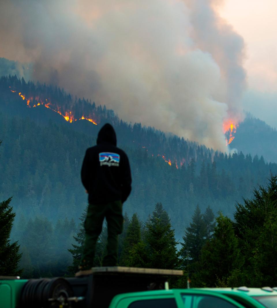
Operations section chief Nick Peters with Northwest Incident Management Team 6 said Monday morning they saw significant fire activity Sunday due to weather conditions, with winds pushing embers as far as a mile and causing additional ignitions west of the fire.
The fire grew significantly in size, up from about 200 acres and crossed over the top of Lookout Ridge. Peters said the same conditions and potential for fire growth continue Monday.
"We are expecting more significant fire behavior due to red flag conditions," he said.
The McKenzie Bridge State Airport closed Friday morning to be used by crews and equipment as a base of operations. Highway 126 between Old Scout Road to Blue River Reservoir will also see an increase in fire traffic.
Norwest Team 6, a Type 2 team, took over management of the fire from Nevada Team 1 on Sunday morning.
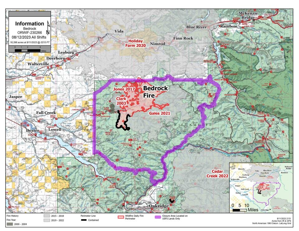
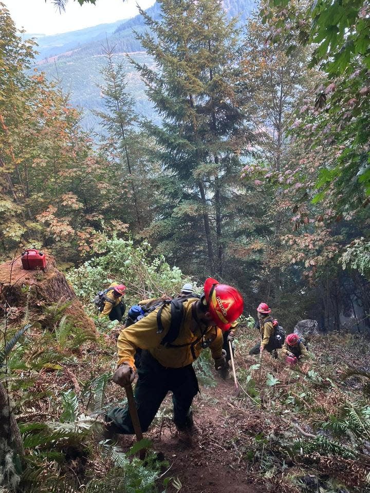
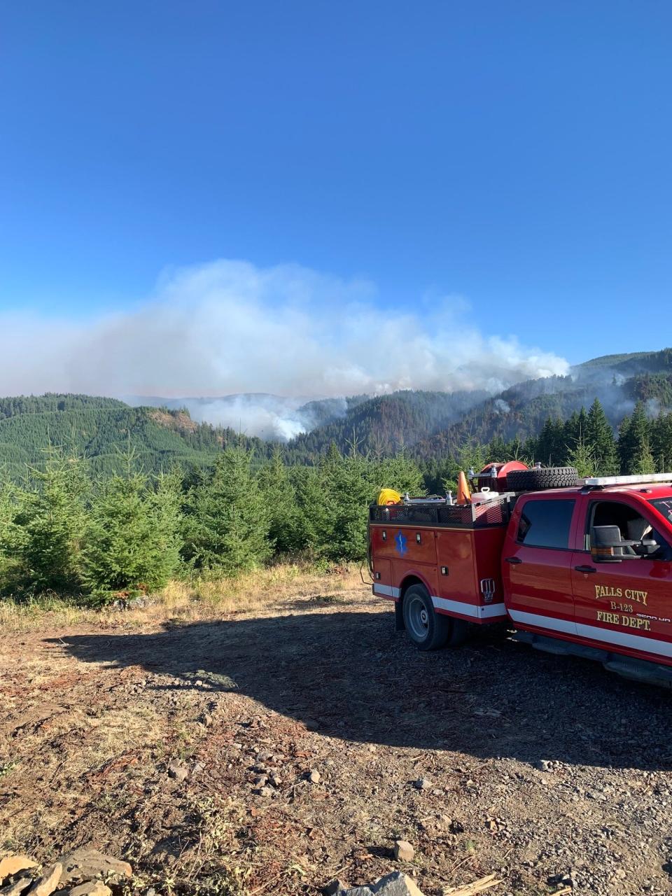
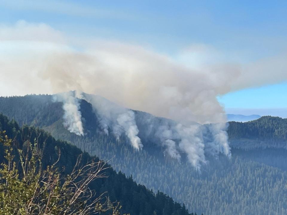
Bedrock Fire and Salmon Fire containment efforts continue
Officials Monday said the southern, eastern and northern portions of the Bedrock fire "look really good" as firefighters keep the fire contained and clean up.
The issues are focused on the western edge of the fire, where they're seeing spot fires due to winds that carried some embers 3/4 of a mile. The fire has now crossed west of the 1817 Road and south of the 18 Road. More resources are headed to that area to assist the nearly 1,000 personnel already there.
The Oregon State Fire Marshall is overseeing structural fire protection of homes in the Fall Creek area.
The 22,679-acre Bedrock Fire was reported at 20% containment Monday while the 135-acre Salmon Fire was reported to be at 80% containment. The two fires burning in the Willamette National Forest are close enough that fire teams are able to share resources and management between them. The causes of both fires are still under investigation.
Saturday marked four weeks since the Bedrock Fire started in the Bedrock Campground, an area that was previously a mix of burnt or untouched forest. The Salmon Fire started Aug. 5.
The two fires east of Lowell and Oakridge caused two emergency closure orders in the Willamette National Forest. The Bedrock Fire order went into effect July 24, while the Salmon Fire caused the closure to expand earlier this week for public and firefighter safety.
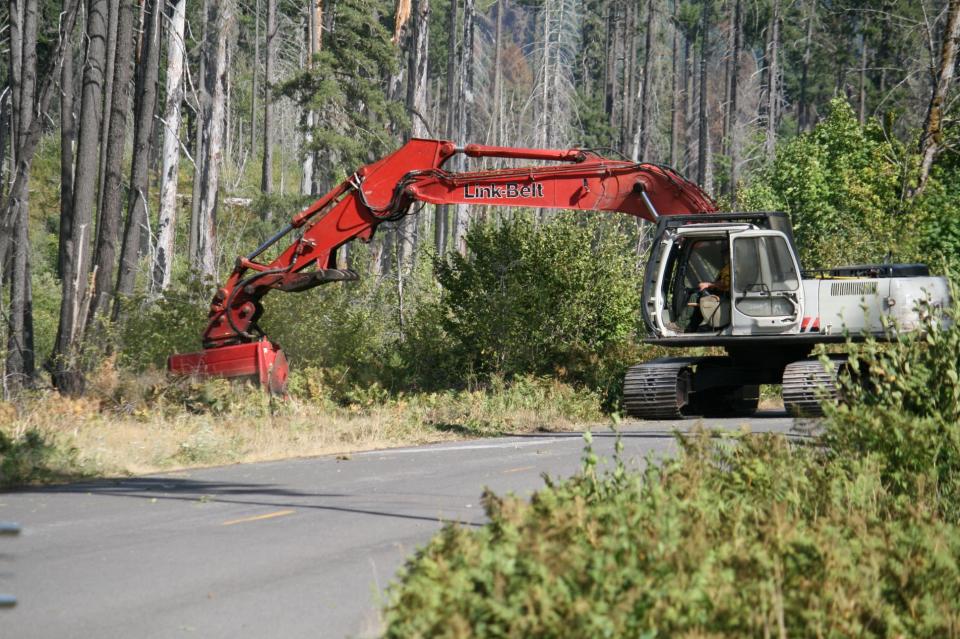
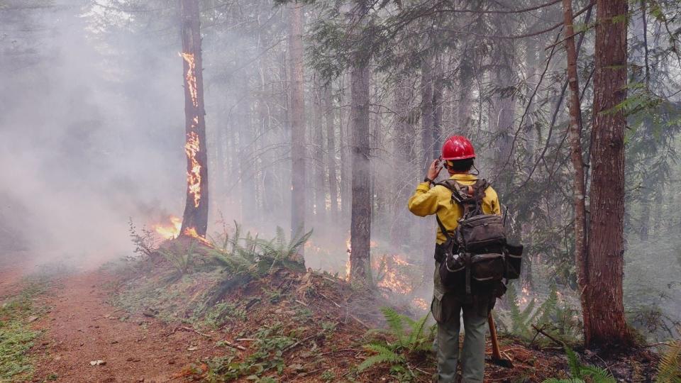
Helicopters have played a large part in containment efforts over the past several days. Water buckets from above are being used to cool and slow fire growth, while firefighters are preparing control lines for burnout operations.
Burnout operations on the Bedrock Fire's perimeters have created some visible smoke in the area. Crews on the Salmon Fire secured containment lines and were working on mop-up efforts.
“A red flag warning is in effect tonight through Monday evening for winds and low humidity which will be favorable for rapid fire growth,” a Saturday update said.
Seven new fires started in the Willamette National Forest within a week, according to the U.S. Forest Service. Not including another two abandoned campfires, five started by lightning. In all, 30 have been put out in the forest this year.
Wiley Creek Fire efforts ramp up
With the heat and windy conditions, the fire team’s efforts are focused on defending the perimeter of the fire. The fire was measured at 241 acres.
Burning six miles southeast of Sweet Home, the fire is at 15% containment and has prompted two evacuation warnings. A level 2 "be set" evacuation notice was issued by the Linn County Sheriff's Office for areas including:
The intersection of Highway 20 at Whiskey Butte Drive then continuing down Whiskey Butte Drive.
Cedar Creek Road, extending south to Wiley Creek Road.
From the intersection of Cedar Creek Road and Wiley Creek Road, east along the south boundary of the Willamette National Forest area to Swamp Mountain Road.
Along Swamp Mountain Road north to Highway 20.
The Wiley Fire also prompted a temporary closure order for Green Peter Reservoir for fire suppression efforts on Tuesday. Air resources are being used for all four fires in the Willamette National Forest.
The successful focus over the weekend was on holding and strengthening existing containment lines.
Small firing operations are helping those preparing the fire lines. On steep slopes, bulldozers are anchored with tethers to create the lines. In the air, three helicopters, two single-engine air tankers and one large air tanker are providing water and retardant drops.
The Oregon State Fire Marshal also mobilized two task forces Thursday night from Multnomah and Polk counties to assist with the fire.
Flat Fire at 56% containment, closures still in place
Passing 56% containment, the Flat Fire is now 33,874 acres. Burning near the town of Agness and the confluence of the Illinois and Rogue rivers, the fire is currently the largest in Oregon but also has the highest containment percentage.
The Flat Fire started July 15 at Oak Flat Campground, and has been listed as “human-caused.” No other details have been released.
The closure issued by the Rogue River-Siskiyou National Forest is still in place for the fire area. That includes trails, roads, campgrounds and part of the Illinois River. More information can be found on the Forest Service website.

A level 1, “get ready” evacuation warning from the Curry County Sheriff's Office is also still in place for part of the Flat Fire.
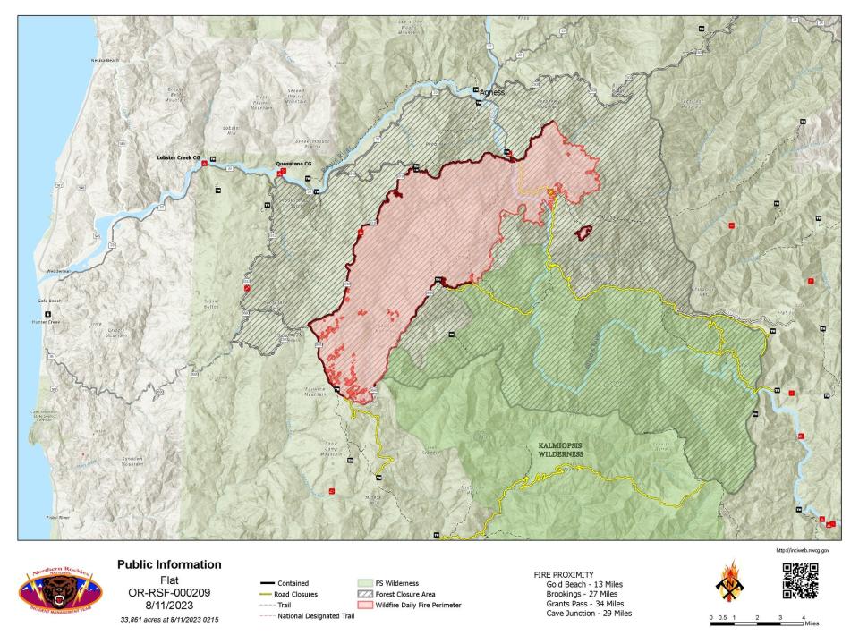
Air resources were being used to watch for increases in fire behavior, and occasional flare-ups were also expected over the weekend. Ground and air crews will continue moving further into the fire's footprint and around the perimeter to extinguish any hot spots.
Abigail Landwehr is an outdoors journalism intern for the Statesman Journal. She can be reached at alandwehr@gannett.com
This article originally appeared on Salem Statesman Journal: Level 3 Go Now orders still in effect for Bedrock, Lookout fires

