Salmon River trails showcase titanic old-growth ideal for winter hiking
There's nothing that quite compares with exploring Oregon’s temperate rainforests in the dead of winter.
Skyscraper trees. Moss and lichen hanging from every branch. And that fresh, wet, earthy smell.
It’s enough to knock the cobwebs from your brain during a time of year when, for many people, winter has overstayed its welcome but shows no signs of departing.
What’s the best place to go?
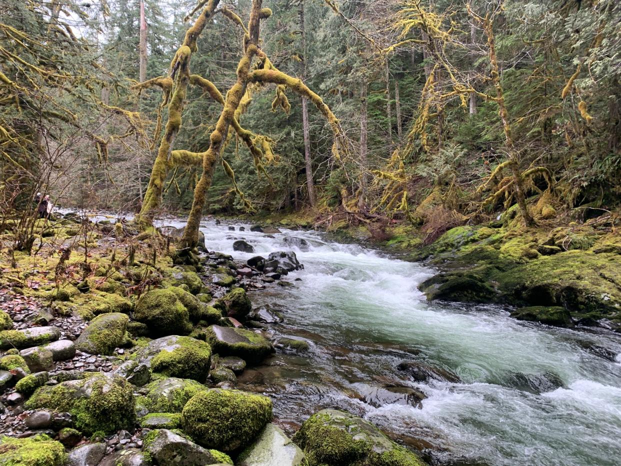
One spot that captures all the rainforest magic, and injects oxygen-rich air into your cranium, is the Salmon River trails in Mount Hood National Forest about an hour east of Portland.
Conveniently, there are easy, medium and challenging ways to experience the area off Highway 26 near Welches. Each trail along this wild river has unique charms, including titanic old-growth trees, a deep wilderness canyon and a place where you can watch fish from an underwater viewing chamber.
The places I traveled earlier this month include the Wildwood Recreation Site, Old Salmon River Trail and the Salmon River Trail into the Salmon-Huckleberry Wilderness.
All three are typically open year-round — with the exception of low-elevation winter storms.
On a sentimental note, the area reminds me of the Little North Santiam and Opal Creek area — the most beautiful old-growth temperate rainforest in Oregon until it was roasted by the 2020 Labor Day fires. The Salmon River area isn't quite the same, but there are a lot of similarities.
Weather
The elevation for the Salmon River trails is generally 1,200 to 1,600 feet, which means it usually doesn't have much or any snow. However, low-elevation storms, like the one we recently had, do bring snow to the area so check conditions before heading out. If it's too snowy, just wait a while and it will normally melt out. Call the Zigzag Ranger Station for info: 503-622-3191.
Crowds
Even in winter, because it's normally snow-free, there are some weekend crowds of Portlanders. It doesn’t reach the overflowing levels of summer, but getting started early isn’t a bad idea for solitude and a parking spot. The Wildwood area has the most parking and is your best bet if things are busy.
Ski traffic
Highway 26 can get a little dicey between Portland and Government Camp on winter weekends and holidays due to the potential to get stuck in Mount Hood ski traffic.
So, if you’re going on the weekend, be prepared. I avoided it by driving to the trailhead early, leaving Portland by 7 a.m. and then returning by around 2 or 3 p.m. That doesn’t mean you’ll miss it entirely, but it helps your chances.
You could also wait until later in the day, to miss the outgoing traffic, I’ve been told, but then have to watch out for incoming traffic. No matter how you do it, be aware that ski traffic could be an issue.
Lodging
If you’re making a longer trip, why not stay a night and explore the whole area? I love the idea of hiking the Salmon River trails one day, and skiing Hood the next. A quick Google search of lodging in the Welches area will turn up plenty of options.
Camping
The Green Canyon Campground is right in the heart of the Salmon River. It’s closed in winter but open May 13 to Sept. 9. All the sites are first-come, first served. There are places to tent in the Salmon-Huckleberry Wilderness area.
Wildwood Recreation Site
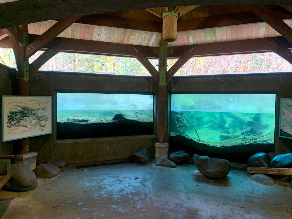
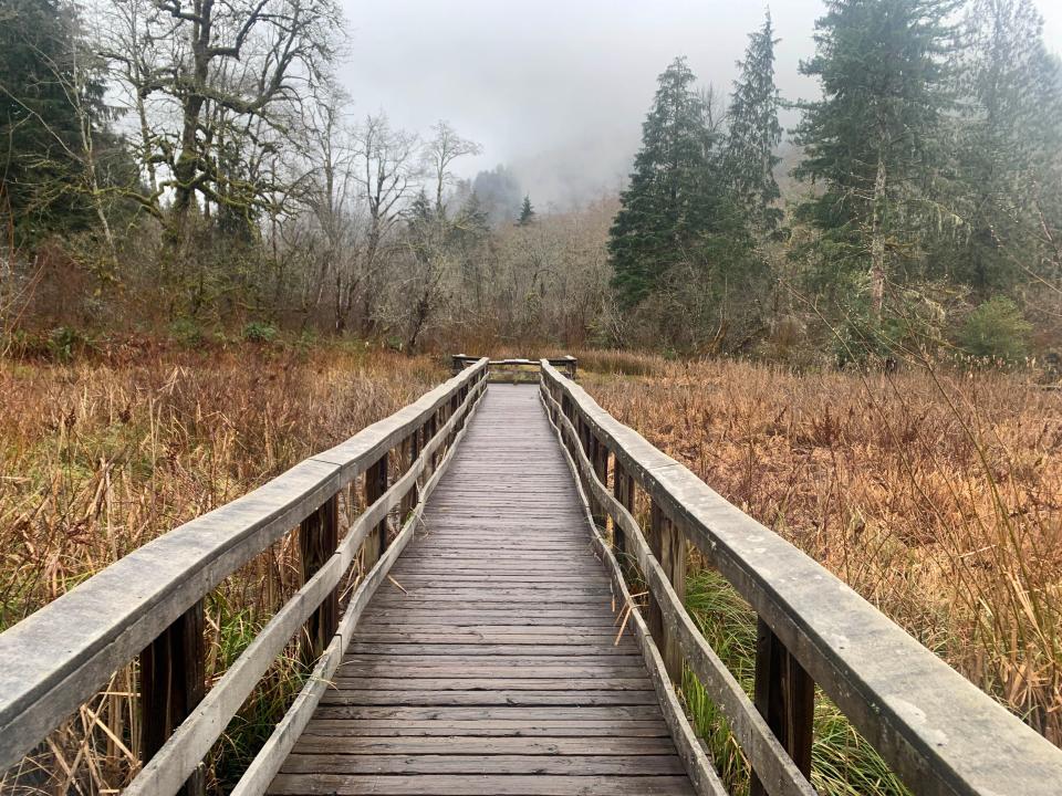
Of the three options, this area is the most developed and family-friendly. It’s also elegant, and features benches with artwork carved into them. The trails are packed with educational displays including a boardwalk route and an underwater viewing area. Its two main pathways — each flat and less than a mile — are handicap accessible.
Entry fee is $5 and can only be paid with a credit or debit card.
The name “wildwood” always brings to mind “Wind in the Willows,” where the wildwood is the rough and tumble part of town, full of stoats and weasels up to no good, but also noble Mr. Badger. There was no sign of Mr. Badger in this case, but there was a warning about a cougar in the area, so keep your head on a swivel.
Cascade Streamwatch Trail (0.75 miles, very easy)
The first pathway to explore is the Cascade Streamwatch Trail. It’s paved and weaves through second-growth forest and along the river with numerous educational displays. There’s a 3D replica of the Salmon River drainage, a chart detailing when each species of salmon spawns and most impressively, a fish viewing window below stream level. You walk down into a paved underground room with plexiglass looking at the bottom of a small tributary where fish can be seen. I didn’t see any fish during my trip, but it was still very cool.
There are fun historical and Indigenous stories scattered about on displays, including a fun one about how coyote disguised himself as a baby and tricked five women to destroy a dam that was preventing salmon from swimming upstream.
Wetland Trail (1 mile, very easy)
The 1-mile Wetland Trail heads out onto a boardwalk into a mountain marsh home to a cattail marsh, beaver dam, ghost forest, skunk cabbage corner and wetland stream. At each stop, you can read from the diary of a field naturalist with observations in each spot.
“Silhouettes of dead trees rise out of the gray mist looking a bit eerie. I sneak up on the ghost forest … ‘quack quack quack’ comes from the far side of the pond,” reads an observation about a collection of ducks who live in the habitat of dead trees preserved in the marsh.
Boulder Ridge (11.5 miles round-trip, 3,000 feet climb, difficult)
Those up for adventure can climb up steep Boulder Ridge Trail to big views of Mount Hood. I didn’t make the trip because the 4,300-foot summit is snow covered in winter, but in spring or summer, it would be worthwhile. It’s just under 12 miles and 3,000 feet of climb to the Boulder Ridge summit.
East Salmon River Road corridor
East Salmon River Road, off Highway 26, is short but packs a lot into it. There’s a campground — Green Canyon, only open in summer. There are four trailheads and multiple places to park and head down to river beaches on hot summer days. It apparently gets quite busy. No camping is allowed except at the campground.
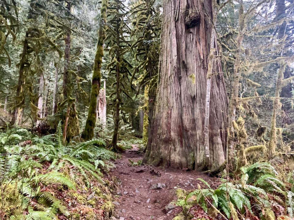
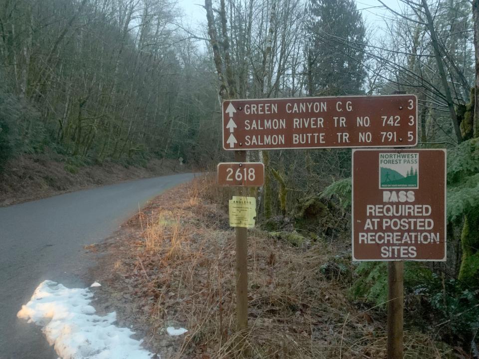
Old Salmon River Trail (5 miles out-and-back, easy/moderate)
This was my favorite hike along the Salmon River — and it’s just about perfect for kids. It’s flat and a little more than 5 miles out and back, although you could easily do a shuttle for a 2.5-mile one-way trek. There are multiple trailheads, but the first one is 2.7 miles down East Salmon River Road from Highway 26, just past the national forest boundary.
A Northwest Forest Pass is required to park here. You can buy them at the nearby Zigzag Ranger Station, although it’s not open on weekends. There is no way to pay without a pass.
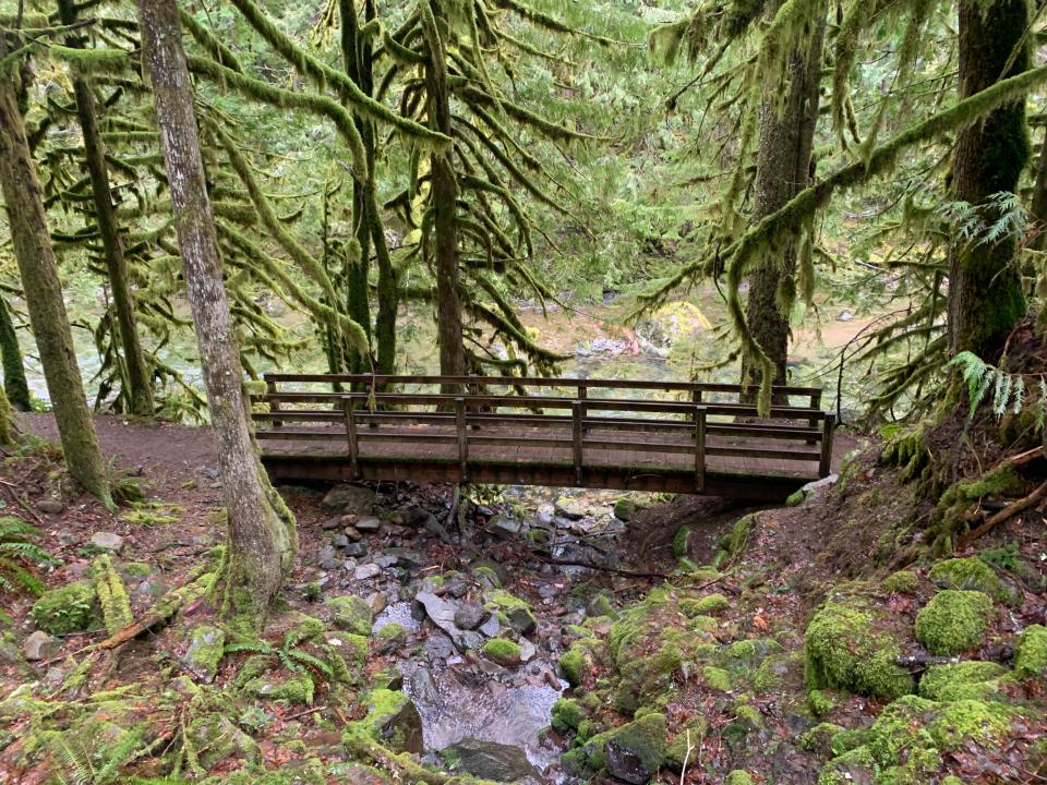
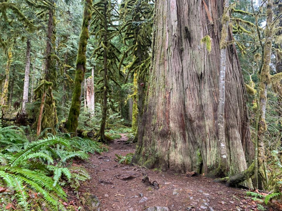
The trail follows the road, and actually joins the road in a few places before diving back into the forest. Even with that intrusion, this is a magic pathway. The Douglas fir and western redcedar trees are massive and dripping with moss. The river rolls along emerald and clear. Elegant footbridges cross tumbling streams. Multiple side trails lead to sandy beaches along the river. The highlight was, a half-mile in, passing a redcedar that must have been 10 feet in diameter and looks the size of a giant redwood from its base.
The hike stays impressive the entire length, until it reaches Green Canyon Campground and eventually the road, right at the West Trailhead for the Salmon River Trail into the Salmon-Huckleberry Wilderness.
The two trails are considered separate — and they are different — but you could easily hike the Old Salmon Trail directly onto the Salmon River Trail, for one longer adventure.
As for why there is a different name between the two trails, there isn't a ton of information. Even officials with Mount Hood National Forest weren’t exactly sure. Writer and historian Tom Kloster probably teased it out best in his post about the hike in at OregonHikers.com. He wrote: “During the height of the post-World War II logging heyday, the Salmon River Road was built along the lower river, bypassing several miles of the old trail that once provided sole access to the upper canyon of the Salmon River. Somehow, the old section of trail paralleling the new road survived the logging era, along with some of the best old growth forests within easy reach of Portland. The trail has since been rediscovered, and once again maintained by the Forest Service for hikers looking for an easy, stream-side ramble.”
Salmon River Trail (4 or 7 miles round-trip, medium/difficult)
The last of the three hikes on the Salmon River heads into the remote canyonlands of the Salmon-Huckleberry Wilderness. A Northwest Forest Pass is required.
There are multiple options here in summer — including a steep trek to a fire lookout — but in winter there are really just two recommended treks, and maybe just one depending on conditions.
The hike starts at the Salmon River West Trailhead and for the first 2 miles follows the river into a narrowing canyon that feels wilder than the previous hike. There are more big trees and canyon views.
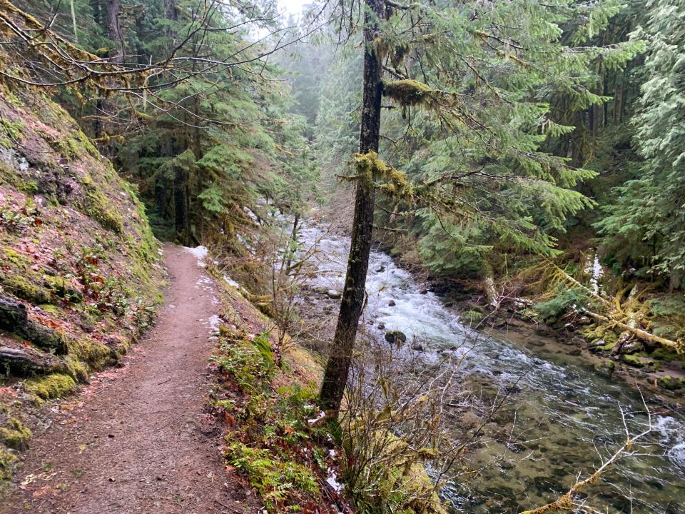
After 2 miles, you pass a Rolling Riffle Camp — designated by a sign — and 10 riverside campsites. They’d be doable, if chilly, in winter. Turn around here and it’s 4 miles out and back.
Beyond, the trail climbs uphill above 2,000 feet and into elevations that may well have snow. Continue at your own risk. Around 3.5 miles from the trailhead is an excellent viewpoint of the Salmon River Canyon and the sound of waterfalls below.
Hiking author Bill Sullivan does not recommend attempting to seek out the waterfalls (especially in winter). Sullivan writes in his book, "100 Hikes in Northwest Oregon," the scramble trails are “slippery, extremely dangerous and not recommended.”
A better way to see the waterfalls is watching the excellent Oregon Field Guide episode, “Waterfall Kayaking,” in which extreme kayakers tackle the Salmon River Canyon you can hear but not see from the trail.
Another interesting note, again from Kloster, is this area was once the site of a planned road that would have connected to Highway 26. The plan was halted by the establishment of the Salmon-Huckleberry Wilderness in 1984.
Zach Urness has been an outdoors reporter in Oregon for 15 years and is host of the Explore Oregon Podcast. Urness is the author of “Best Hikes with Kids: Oregon” and “Hiking Southern Oregon.” He can be reached at zurness@StatesmanJournal.com or (503) 399-6801. Find him on Twitter at @ZachsORoutdoors.
This article originally appeared on Salem Statesman Journal: Salmon River trails showcase titanic old-growth ideal for winter hikes

