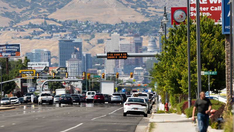
Salt Lake City ends up with 3rd hottest July on record — but relief is in the forecast
Last month produced yet another hot July in Utah's capital city.
Salt Lake City's average temperature last month jumped up to 85.3 degrees Fahrenheit, placing it in a tie with 2017 for the third hottest July in the city's history, according to National Weather Service data.
While July is typically one of the city's hottest and driest months, it's the city's third straight July to land in the top five behind the record of 87.3 set in 2022 and 85.7 degrees the July before that. The agency's Salt Lake records date all the way back to 1874, while the 30-year normal average temperature is 81.1 degrees.
This year's average temperature was boosted by 12 triple-digit heat days — six fewer than last year but four times the July average. The city averages about four 100-degree days every year even with the heat surge in recent years. Salt Lake City's average high of 98.3 last month also ended up the third highest on record, while its 72.2 average overnight low ended up fourth.
It also only recorded 0.06 inches of precipitation, which is 0.43 inches below normal.
While the National Centers for Environmental Information is gathering statewide July climate data, somewhat similar hotter- and drier-than-normal trends emerged in other parts of the state where the weather service has publicly accessible data:
Alta: 63.1 degrees and 0.35 inches of precipitation; normal is 61.6 degrees and 1.48 inches.
Cedar City: 77.4 degrees and 0.17 inches of precipitation; normal is 74 degrees and 1.02 inches.
Jensen: 75 degrees and 0.27 inches of precipitation; normal is 72.2 degrees and 0.41 inches.
Logan (KVNU): 73.7 degrees and 0.44 inches; normal is 72.1 degrees and 0.50 inches.
Moab: 84.4 degrees and a trace of precipitation; normal is 82.7 degrees and 0.92 inches.
Provo (BYU campus): 81.5 degrees and 0.18 inches of precipitation; normal is 78.8 degrees and 0.51 inches.
St. George: 89.8 degrees and 0.02 inches; normal is 86.8 degrees and 0.50 inches.
So what was behind these trends?
July started off fairly normal with a high-pressure ridge setting up over the Southwest, providing Utah's first real heat of the year after a colder-than-normal first half, said Mike Seaman, a meteorologist for the National Weather Service's Salt Lake City office. However, things started to change after that, playing into the possible delayed and weaker monsoonal pattern that meteorologists said could happen this summer.
"During a normal year, that'll set up across the Four Corners and that will start to bring monsoonal moisture north into (Utah) — that didn't really happen this year in July," he told KSL.com Tuesday. "We saw that ridge set up a little west across the Great Basin and that kept the monsoonal moisture, as well as cooler temperatures, suppressed south of us."
This brought in hotter and drier air masses over the state, resulting in above-normal temperatures and drier-than-normal conditions. It's similar to what happened over the previous two Julys in Salt Lake City, in particular.
"We've certainly seen, recently, a number of anomalously hot Julys across the West, specifically here in Utah," Seaman added. "Really, our summertime patterns are dependent on where this larger-scale ridge sets up."
That said, with the wet and cool first half, Utah's drought situation didn't change much in July. The U.S. Drought Monitor lists 9.7% of the state in a moderate drought, down slightly from 10.4% at the end of June. The percentage of Utah listed as "abnormally dry" also dropped from 47.9% to 43.6%, even as the state has dried out.
Yet Utah's fire risk did increase in July, Seaman said.
Why August could be a 'mixed bag'
For those who aren't a fan of the heat, there is relief in sight — and already here.
Monsoonal moisture started to return to Utah at the end of July and continues to move through the state to start August. KSL meteorologist Matt Johnson explained that a low-pressure system set up southwest of Utah Tuesday helped push precipitation up from Arizona, producing scattered showers and thunderstorms across the state. It led to some flash flooding events in Utah's canyons.
This pattern is expected to continue Wednesday and into parts of Thursday.
"I'm calling it a case of the haves and have-nots, because not everybody gets the rain," he said.
There is an increased risk of flash flooding for southern Utah National Parks and recreation areas. Make sure to check in with local visitor centers or ranger stations before heading out and have a plan if threatening weather approaches. More at: https://t.co/7kgSJIQzx7 #utwx pic.twitter.com/bSWGUD9YRH
— NWS Salt Lake City (@NWSSaltLakeCity) August 1, 2023
High temperatures may only top out in the upper 80s and lower 90s along the Wasatch Front this week, as well. Full seven-day forecasts for areas across Utah can be found online, at the KSL Weather Center.
This trend may also continue throughout the month. The weather service's Climate Prediction Center released its final August long-range outlook on Monday, placing most of Utah in "equal chances" when it comes to temperatures and precipitation. That means there is no clear indication of whether it will be hotter, colder, wetter or drier than normal this month.
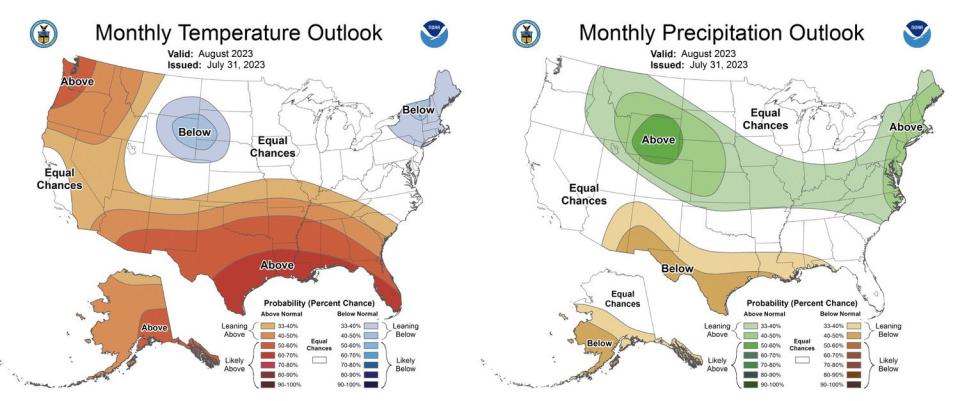
A large section of western Utah has a greater probability of above-normal heat, while parts of northern Utah have a slightly greater probability for above-normal precipitation. That said, Salt Lake City's August precipitation normal is only 0.58 inches, so it may not be that much rain.
Seaman said the outlook indicates there is a possibility that conditions will be closer to normal than what Utah's weather has been this year. August typically tends to bring days of monsoonal showers and clear-sky days, with some heat and cooldowns mixed in between.
"That's kind of what we're looking at," he said. "We're not going to be in a pattern where we see a strong monsoon surge of moisture for a long period of time. It's going to be kind of a hit-and-miss month, where we get a little bit of moisture here and there, a little bit of dry; we'll have some hot days and some cooler, rainy days — kind of a mixed bag that we're looking at."

