San Joaquin River flood possible as new storm hits Stockton area
San Joaquin County will be hit by another storm system Tuesday and Wednesday, the National Weather Service said, adding additional concern to the already water-logged region and rising rivers.
Evacuation orders are in effect for the Airport Court and Haven Acres Mobile Home Park and Marina communities along the San Joaquin River due to hazardously-high water levels. Turtle Beach, south of River Islands along the San Joaquin River, was under an evacuation warning as of midday Monday.
Early estimates show rainfall at nearly an inch over the next two days.
Tiffany Heyer, San Joaquin County director of Emergency Operations, said the evacuation orders and warnings have affected about 100 county residents. An evacuation shelter has been set up at the Manteca Senior Center at 295 Cherry Lane, Heyer said.
The large animal or livestock evacuation center is at the San Joaquin County Fairgrounds.
“The high-water levels along the San Joaquin River in Vernalis can swiftly change depending on the residual runoff, actual rain totals, snowmelt and water releases from surrounding reservoirs,” Heyer said in a statement. “(We) and reclamation districts are monitoring water levels and will coordinate with our partnering agencies to reassess evacuation warnings as needed in impacted areas.”
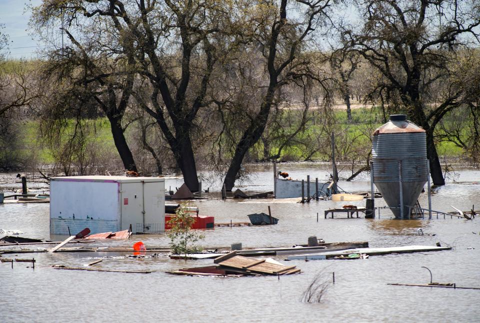
The San Joaquin River passed the “danger” stage early morning Saturday, March 18. The California Nevada River Forecast Center predicts the river will hover around the 29.5-foot danger line — past the flood stage — through at least Saturday, March 25, as far as the projections read out.
Danger stage is when a body of water flows at greater capacity than the maximum the protecting infrastructure was designed to hold, according to the National Weather Service, where there is "extreme danger with threat of significant hazard to life and property in the event of a levee failure."
Though the Tuesday storm system is now projected to hit southern California harder than the north, Stockton could still be in the storm’s path; the National Weather Service said isolated thunderstorms, wind, rain and possible hail will hit primarily from Interstate 80 southward. Cooler temperatures will bring snow Tuesday and Wednesday as low as 3,000 feet in the mountains.
For more storm information or evacuation updates, visit SJReady.org or text “SJStorms” to 888777 for direct notifications from the County.
This article originally appeared on The Record: Eyes on San Joaquin River as storm hits Stockton area

