As San Joaquin River flows increase, flood conditions near Fresno are ‘right at the edge’ | Opinion
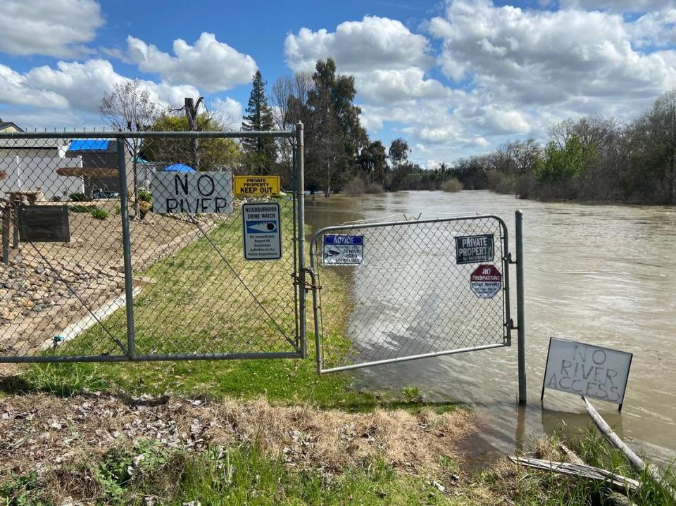
Whenever the San Joaquin River rises in Firebaugh, Ymelda Ramos can feel her anxiety levels rise.
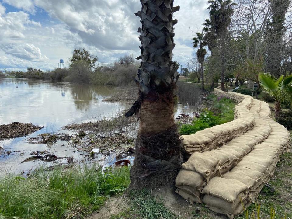
But recently Ramos saw something that both gave her calm and made her nervous simultaneously: A crew of three dozen (from Cal Fire, California Conservation Corps, National Guard and Department of Corrections) filling and erecting a wall of sandbags — 6,000 of them — between the river and the small nine-room motel she manages.
Ramos felt happiness and relief in knowing people cared enough to protect the motel and nearby homes from flooding. And concern in knowing only a sizable threat would warrant all that effort.
“This is excitement for Firebaugh — and worrying,” she said.
The Riverfront Inn sits on the outside bend of the San Joaquin River following a straight section. At high flows, all that fast-moving water suddenly must veer right. Some of that momentum can’t help but continue straight ahead into the grounds of the motel.
Opinion
In a state Department of Water Resources survey, the riverbank behind the motel was identified as a community low spot. Which explains why the crew labored nine hours to place the sandbag wall in that location. (An even larger wall, 12,000 sandbags worth, was erected across town to protect the city’s wastewater treatment plant.)
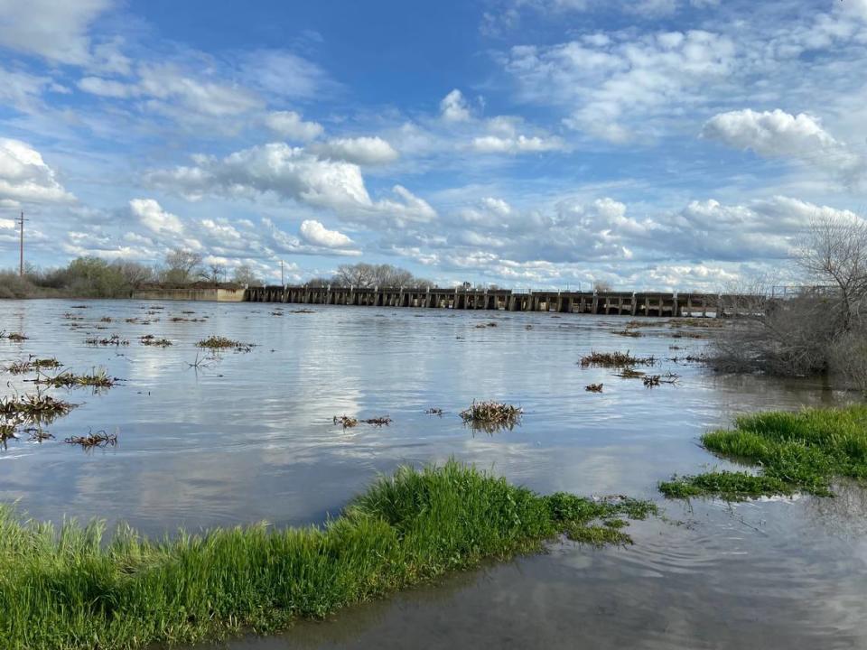
Water released into the San Joaquin River from Friant Dam takes about a day to reach Firebaugh. A 2015 report prepared by city officials for a state funding presentation for levee improvements identified river flows above 4,000 cubic feet per second as enough to require sandbagging and flood-fighting efforts. By Tuesday, measured flow rates about 8 miles upstream near Mendota Pool exceeded that number.
Ramos has managed the Riverfront Inn for nearly a decade. Only once during that time, in 2017, has she seen the water this close to the motel’s back lawn. She worried then too, but levels receded after a week or so. This year, she’s bracing for months of high flows.
“There’s a lot of snow in the mountains,” Ramos said. “Everybody’s scrambling to transfer water.”
From not enough water to too much
Michael Jackson is one of those people. As manager of the Bureau of Reclamation’s South Central California Area Office, Jackson’s responsibilities include the operations of Friant Dam.
With California in a continuous drought cycle since 2006, Jackson’s primary concern has been surface deliveries to Valley irrigation districts via the Friant-Kern and Mendota canals while meeting federally mandated minimum flows for the San Joaquin River Restoration Program.
This year, there’s too much water. Jackson bears the tricky and weighty responsibility of managing the level of Millerton Lake so as not to cause flooding in places like Firebaugh while also being mindful of the enormous southern Sierra Nevada snowpack that has yet to melt and make its way down the watershed.
“We have concerns for any significant flooding that may happen later this year,” Jackson said. “Things are going to be right at the edge of containing (communities) from damaging flows. We’ll just do the best we can and remain optimistic while taking prudent actions.”
After the heavy snowfall over Christmas and early January, Friant Dam operators ramped up discharges into the river from 600 cfs to 1,650 cfs and then as high as 4,500 cfs for several days before returning to normal winter flows. On March 9 they were again raised to 2,500 cfs and have been steadily climbing until increasing to 8,800 cfs on Wednesday morning.
The San Joaquin River can “safely” handle releases of up to 9,000 cfs, according to Jackson. The first flood “challenge” is the mobile home park near Highway 41 on the Madera County side, followed by the one on the Fresno side. Parks, golf courses and a few farmland areas tend to take on water next.
“We can go as high as 10,500 (cfs), but we don’t want it to get to that level,” Jackson said. “Then you’re at the edge and any little bump can put you over the top.”
Matter of time until Millerton spills
On Tuesday, the average discharge into the San Joaquin River measured 8,482 cfs for the prior 24-hour period. Combined with discharges into the Friant-Kern (1,100 cfs) and Madera canals (827 cfs) — Jackson said both are maxxed out due to flood conditions affecting downstream waterways — that makes for a total average release of 10,409 cfs.
However, inflows measured 10,714 cfs. Meaning the lake went up a little, to 80% full, despite all the water going out.
If that pattern continues, it’ll only be a matter of time until Millerton Lake exceeds its 520,500 acre-foot capacity and water spills from the top of the dam through three buoyancy-controlled gates.
Until the mid 2000s, water spilling from the top of Friant Dam was a fairly regular occurrence. The last time was July 2017, and before that 2011.
Even though it seems inevitable, Jackson did not wish to predict if or when Friant Dam will spill over. Or whether downstream flooding the magnitude of what occurred in January 1997, when peak flows measured nearly 60,000 cfs and forced mass evacuations in Firebaugh, is inevitable.
“All I can say is it’ll be touch and go,” he said. “There’s 3.2 million (acre-feet of water) yet to come and we’ve got a reservoir that’s 520,000 acre-feet of capacity. So that runoff yet to come is about six times the capacity of the dam.”
The math, for both dam operators and motel managers in Firebaugh, is daunting.