Santa Ana winds to return across Southern California this week

Strong winds will howl across parts of Southern California this week that could cause damage and increase the risk for wildfires, following on the heels of a Santa Ana event that took place just this past weekend.
Santa Ana winds, which occur when winds blow and pick up speed as they travel from the inland deserts toward the coast, can have wide-reaching impacts in the Los Angeles area during the fall and winter months.
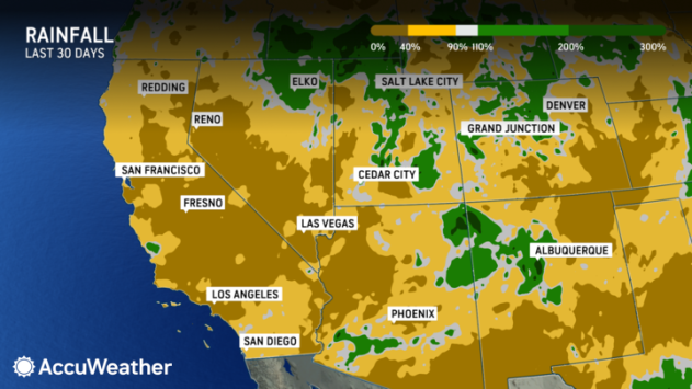
It has been bone dry across Southern California since the start of December, and in Los Angeles, measurable rain has not fallen since Nov. 18. The extended dry spell combined with low humidity and the upcoming Santa Ana winds could create a recipe for wildfires.
 |
"A storm moving from the Rockies into the Plains is often a perfect recipe for offshore wind events in Southern California, and this week will be no exception," AccuWeather Senior Meteorologist Jake Sojda said.
Besides triggering tricky travel conditions at times, the strong winds will also be dry, leading to other hazards. "Since the wind descends from the deserts, they will be very dry which can lead to high fire risk," Sojda added.
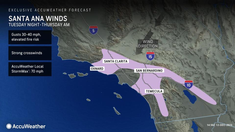
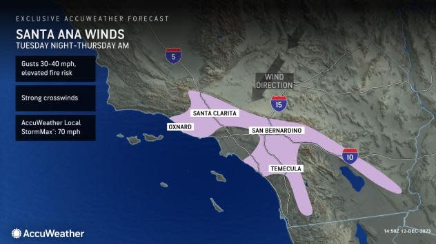
That risk of fires will expand on Wednesday as the Santa Ana event ramps up in the mountains and valleys of Los Angeles and Ventura counties, AccuWeather meteorologists say. This risk can then remain in place through Wednesday night and into Thursday morning.
 |
The National Weather Service forecast office in Oxnard, which serves the greater Los Angeles area, has offered some tips to prevent quickly spreading wildfires. They include teaching kids about the dangers of playing with fire, not burning trash or brush, not parking vehicles on dry grass and not leaving hot grills unattended.
During the height of the event, winds in the range of 30-40 mph will be common, with a few higher gusts likely. The AccuWeather Local StormMax™ is 70 mph, most likely occurring in the highest elevations.
Winds of this magnitude can cause minor damage and toss around light objects, such as holiday decorations. Travelers, especially in high-profile vehicles may also experience difficulties driving through wind-prone areas along interstates 5, 10 and 15 and other state and county roads.
Gusty winds can continue through Thursday morning before easing back to end the week.
Want next-level safety, ad-free? Unlock advanced, hyperlocal severe weather alerts when you subscribe to Premium+ on the AccuWeather app. AccuWeather Alerts™ are prompted by our expert meteorologists who monitor and analyze dangerous weather risks 24/7 to keep you and your family safer.
