Santa Anas serving up gusty Thanksgiving morning prompt fire — and freeze — concerns
Fierce Santa Ana winds descending on Southern California over the Thanksgiving holiday are stoking fire — and freeze — concerns, dramatically divergent phenomena that can arrive with the seasonal gusts.
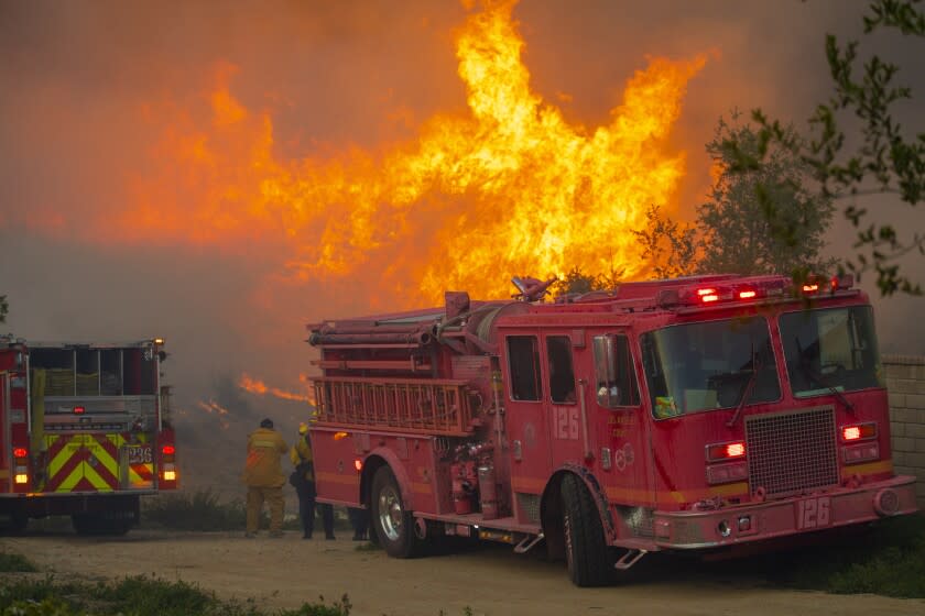
A red flag warning went into effect at 10 a.m. Wednesday for much of Los Angeles and Ventura counties and will last through 6 p.m. Friday, as gusty northeast winds and bone-dry air bring the potential for critical fire weather in the region, according to the National Weather Service.
RED FLAG WARNING in effect from 10am Wed thru 6pm Fri for gusty #SantaAnaWinds of 40-60 mph and very low humidities of 2-8 percent. Now is the time to activate your emergency plan in case of evacuations during a fast-moving #wildfire, even at night. #CAwx #LAweather #ReadySetGo! pic.twitter.com/akstU2hTjq
— NWS Los Angeles (@NWSLosAngeles) November 23, 2021
Gusts are expected to top out between 35 and 55 mph, with intense isolated gusts of 60 to 70 mph potentially blasting foothill and mountain areas. Winds are expected to blow strongest from Wednesday night into Thursday morning, serving up a gusty Thanksgiving morning.
Officials predict relative humidity readings will fall to critical levels on Wednesday afternoon and continue to plummet as low as 2% to 8% by Thursday and Friday along with "very poor overnight recoveries, especially in mountain areas," according to the warning.
Winds are expected to weaken by Friday, but the low humidity and occasionally gusty winds will keep fire danger high through the afternoon, according to the warning.
"Any new fire starts could spread rapidly!" the weather service warned in a tweet, noting in a different tweet that residents should have an emergency plan in the event of evacuations triggered by a fast-moving wildfire, even at night.
Temperatures in coastal and valley areas are expected to hover in the mid-70s through Thanksgiving before warming slightly on Friday and into the weekend, said Ryan Kittell, a meteorologist with the weather service's Oxnard station.
Beaches might see the warmest temperatures on Wednesday and Thursday. "That's usually the case with Santa Anas," Kittell said, explaining that the air warms as it drops in elevation.
Southern California Edison said Tuesday that nearly 99,000 customers could be affected by public safety power shutoffs to reduce the danger of fire from utility lines knocked down by winds.
Inland areas of Riverside, San Bernardino, Ventura and Los Angeles counties could see the largest outages, the utility said. Kern and Orange counties also could be affected.
Often associated with warm, dry air, Santa Anas can shuttle in cold air from the Great Basin to the Southland's interior valleys and mountains, the weather service said. There's a potential for temperatures to dip well below freezing in the Antelope Valley, which is not included in the red flag warning, on Wednesday and Thursday nights.
"Not all Santa Anas are warm — it all depends on what kind of air is coming into the area," Kittell said. Stronger Santa Anas are often associated with colder events, he said, with this event expected to be moderate to strong.
Weather officials advised residents to be prepared to protect sensitive plants and shelter outdoor animals amid frigid conditions. Temperatures between 33 and 36 degrees can damage plants left outside, while 32 degrees and under can kill them.
For areas that frequently experience subfreezing conditions, such as the Antelope Valley, freeze warnings — often directed at agriculture — are not issued for every event, Kittell said. It's the first few freeze events that tend to pose the most risk to plants, including crops, and the Antelope Valley has already experienced several this season. After that, much of the damage is already done.
No warnings are in place, but officials may issue a hard freeze warning for Thursday night. A hard freeze, in which temperatures drop below 28 degrees, can affect infrastructure such as pipes in addition to agriculture, Kittell said.
#SantaAnaWinds can bring cold air from the Great Basin to our interior valleys & mountains. This will be the case by Wed night with the potential for temperatures well below freezing in the Antelope Valley. #BePrepared to protect sensitive plants & shelter outdoor animals. #CAwx pic.twitter.com/B3HjeMzjaP
— NWS Los Angeles (@NWSLosAngeles) November 23, 2021
Meanwhile, in the Sierra, dry and unseasonably warm conditions are prompting some ski resorts to delay their winter season — a stark reversal after an early-season storm in late October dumped snow on some peaks, leading some resorts at the time to open ahead of schedule.
Lake Tahoe's Sugar Bowl resort this week announced it would not be opening on Friday for the Thanksgiving weekend as planned.
"We held on to hope as long as we could," but a forecast of non-ideal conditions forced a delay, the resort wrote on its website Monday.
No updated opening date was provided for the resort, located on the north side of Lake Tahoe. "As soon as we know, we will let you know," the resort said.
The Heavenly and Northstar resorts already announced they would not be open by the holiday weekend, the Associated Press reported.
Palisades Tahoe and Mammoth Mountain, to the south of Lake Tahoe, had both kicked off their winter seasons early due to a massive storm fed by an atmospheric river late last month. Palisades Tahoe has since closed due to dry weather.
Since that storm, "we've had a pretty long stretch of dry conditions with temperatures not at the level that they need for using their snow making equipment," said Mark Deutschendorf, a meteorologist with the weather service's Reno station, speaking generally about Sierra resorts.
No snow or rain is anticipated for at least the next week, and temperatures are well above average for late November, Deutschendorf said, calling it "more of the same." The holding pattern is expected to last until early December.
A major factor driving warm, dry conditions in Southern California is the emergence of La Niña conditions for a second year in a row.
The phenomenon is associated with warmer, drier winters in the Southwest, and colder, wetter conditions in the Pacific Northwest. Northern California, smack in the middle, is more of a toss-up.
Amid the La Niña encore, Southern California this winter is expected to see below-normal precipitation and above-normal temperatures, according to a 2021 Winter Outlook released by the National Oceanic and Atmospheric Administration, which spans December through February.
South of the Bay Area — throughout Central and Southern California — “prospects for any drought improvement are slim,” said Brad Pugh, a meteorologist with NOAA, late last month.
The Associated Press contributed to this report.
This story originally appeared in Los Angeles Times.

