Santa Paula decides shape of future council elections with district map
The shape of future Santa Paula City Council elections was determined Wednesday when the panel chose a map marking out five council districts in a 3-2 vote.
Councilmembers Leslie Cornejo and Carlos Juarez voted against the map because they wanted the public to have more time to review and comment.
The council will adopt the map during a first reading on March 1. Final confirmation is set for March 15.
The City Council currently has five members elected at-large who serve staggered four-year terms. The mayor's seat rotates among them, which will not change.
Like many other Ventura County cities, Santa Paula is changing to a district system under the threat of a lawsuit under the California Voting Rights Act.
Neighborhoods intact
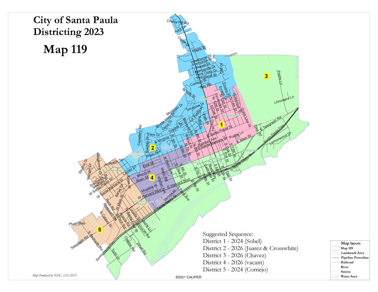
The map, numbered 119, was favored by the Central Coast Alliance Unified for a Sustainable Economy, or CAUSE, and some on the council because It maintained historical neighborhoods and boundaries of interest.
Advocates said the map kept together the farmworker-founded Las Piedras Park neighborhood and renters in the city center, Santa Paula's two largest Latino communities.
Next year, the city will be required to put two districts up for election. Mayor Andy Sobel from the new District 1 and Cornejo from District 5 will be on the November 2024 ballot. The remaining three districts will follow in 2026.
Shape of the future
Here's how the districts were divided:
District 1: The city's middle/eastern area includes Las Piedras Park and runs from Say Road to East Main Street.
District 2: The northern section includes the Santa Paula cemetery and runs from Cherry Hill Road to Mupu Avenue.
District 3: East and south areas include a large swath from Limoneira Lane to Highway 126 and streets south.
District 4: The middle/western section runs from East Santa Paula Street to East Santa Maria Street.
District 5: The city's west side includes Obregon Park and Charles M. Teague Park and runs from Skyline Drive to Highway 126.
Opposition remains
A group of 18 residents, including a former mayor, signed a letter asking council members to reconsider the process because they felt districts take away their right to vote for every council member.
"I have voted since I was 21 years old and the notion that I cannot vote or would not be able to vote for the people of our choosing in this city is repulsive to me," Ginger Gherardi, 80, a former mayor who signed the letter, told the council during comments.
Officials and council members said the risk of paying millions in attorney's fees if the city were to lose in a lawsuit was not worth the risk.
The city has allocated about $100,000 to help with the districting process.
For more information on the map and the process, visit drawsantapaula.org.
Wes Woods II covers the West County for the Ventura County Star. Reach him at wesley.woodsii@vcstar.com, 805-437-0262 or @JournoWes.
This article originally appeared on Ventura County Star: Santa Paula City Council chooses district map for future elections

