5 p.m. update: Sarasota-Manatee under state of emergency due to storm expected to become Hurricane Ian
5 p.m. Update:
In preparing for Tropical Depression 9, Gov. Ron DeSantis issued an executive order, declaring a "state of emergency" for 24 Florida counties, including Sarasota and Manatee, in the potential path of the coming storm.
DeSantis also asked for a "federal pre-landfall emergency declaration" to make key resources and support made available to the state from the federal government. It requires the approval of President Biden.
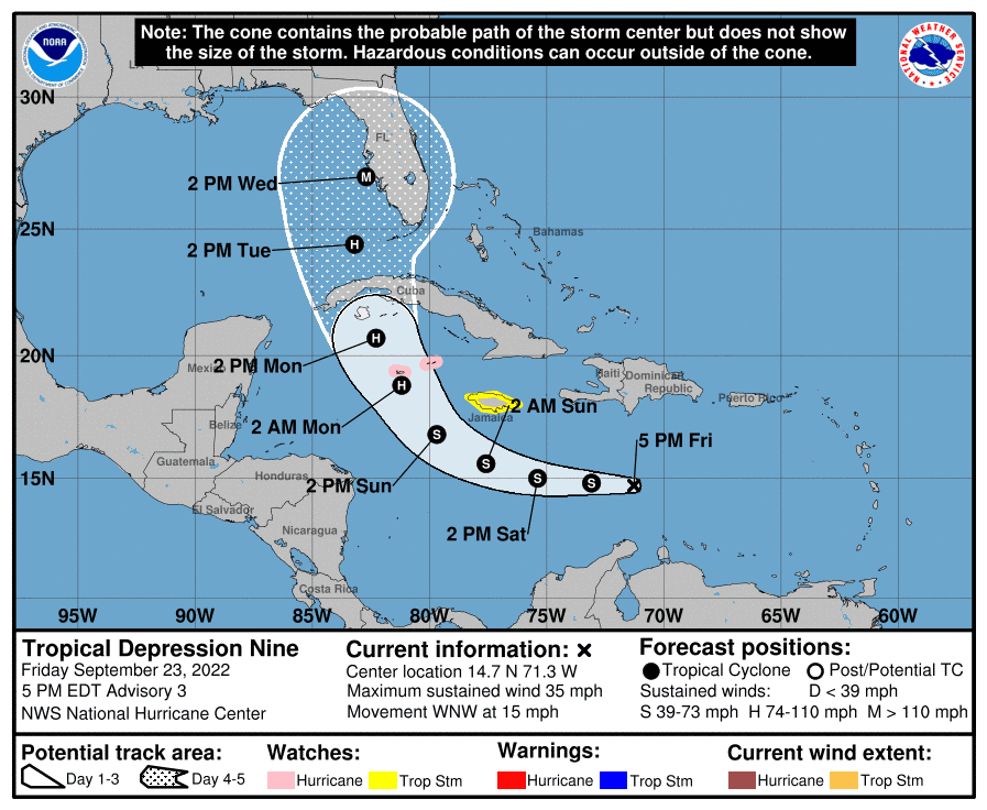
Invest 98L has formed in the Caribbean into Tropical Depression 9 and is expected to become Hurricane Ian by early next week. The National Hurricane Center track Friday evening showed the center of the storm headed to Sarasota and Manatee counties, but forecasters cautioned there is much uncertainty predicting the track of the storm this far out from potential landfall in Florida.
"In fact, this forecast calls for the system to approach the Florida peninsula as a major hurricane by day 5," said Brad Reinhart, hurricane specialist at the National Hurricane Center, "which is supported by the latest IVCN and HCCA aids."
Tropical Depression Nine: See spaghetti models, path and storm activity for Florida
Hurricane Guide 2022: What do you need to know?
Hurricane Shelters: Where are Sarasota-Manatee hurricane shelters? When should I go?
As of 5 p.m. EDT, Tropical Depression Nine had winds of 35 mph. It was headed west-northwest at mph. The National Hurricane Center forecasts some slow strengthening during the next day or so, and the depression is expected to become a tropical storm by Friday night. The NHC also expects more significant intensification on Sunday and Monday, and the system is forecast to become a hurricane by early Monday.
There is still a healthy amount of uncertainty in the track forecast at the day 4-5 timeframe. After the system forms into a tropical storm, a more accurate forecast will be possible.
If Tropical Depression Nine becomes a named storm, it would likely be called Ian, since another storm in the eastern Atlantic will likely develop into a Tropical Storm quicker.
Will Hurricane Ian hit Sarasota-Manatee?
Though Tropical Depression Nine is not expected to become Hurricane Ian until late Sunday or early Monday, most of the predictive models show it impacting Florida near Sarasota and Manatee counties. However, forecasters caution that it is still too much uncertainty to have confidence in the storm track predictions.
"The track is still kind of uncertain," said Christianne Pearce, a meteorologist at NWS Tampa. "The center (of the storm) wobbles in the early stages. We're also not sure that it'll certainly make that turn towards Florida."
When will Hurricane Ian hit Sarasota-Manatee?
If National Hurricane Center and other predictions hold true, Tropical Depression 9 will steadily increase in intensity, becoming Hurricane Hermine by Monday morning, and will impact Florida in the Sarasota-Manatee area at some point on Wednesday.
Stay up to date on the storm: Download the updated Herald-Tribune app
HURRICANE GUIDE: Tips to stay connected before, during, after the storm
Sarasota-Manatee government response
Bill Logan, the information outreach manager for the county, said Manatee County is partially activating their Emergency Operations Center this afternoon, but without permanent staff for now, referring to it as a move of extraordinary caution.
Sarasota County officials put out a statement on their social media Friday morning, stating they are monitoring the storm's progression.
"We're not activated (for an emergency) just yet," Brianne Grant, a media relations officer for the county said. "We're monitoring all activity and recommend residents to review their plans, prepare go-kits and visit our website for storm checklists and tips."
Where can I get sandbags in Sarasota-Manatee ahead of Hurricane Ian?
The City of Venice has announced that the Public Works Department will have sandbags available for residents beginning Sunday, Sept. 25, from noon to 6 p.m. at Wellfield Park off Pinebrook Road.
These are self-filling stations. There is a limit of 10 sandbags per household while supplies last and shovels will be provided. Residents are encouraged to bring their own bags in case the city runs out, as well as their own shovels to expedite the process.
Sarasota County will also begin sandbag operations Sunday, Sept. 25 from noon to 6 p.m. at three locations.
Ed Smith Stadium, 2700 12th Street, Sarasota.
Twin Lakes Park, 6700 Clark Road, Sarasota.
South County Fleet, 4571 SR 776/Englewood Road, Venice.
Shovels and bags will be available on-site, limit 10 sandbags per vehicle.
Sandbag operations are also planned for Monday, Sept. 26 from 9 a.m. to 7 p.m
Tropical Depression 9 (likely to be Hurricane Ian) National Hurricane Center Update
As of 5 p.m. Sept. 23:
Location: 430 miles east-southeast of Kingston, Jamaica
Maximum sustained winds: 35 mph
Direction: West-northwest at 14 mph
Next advisory: 11 p.m. ET
At 5 p.m. EDT, the center of Tropical Depression Nine was located near latitude 14.7 North, longitude 71.3 West. The depression is moving toward the west-northwest near 15 mph.
There is now a Hurricane Watch in effect for the Cayman Islands and a Tropical Storm Watch in effect for Jamaica.
On the forecast track, the center of the cyclone is forecast to move across the central Caribbean Sea through Saturday, pass south of Jamaica on Saturday night and Sunday, and approach the Cayman Islands on Sunday night and early Monday.
Maximum sustained winds are near 35 mph with higher gusts. Some slow strengthening is forecast during the next day or so, and the depression is expected to become a tropical storm by tonight. More significant intensification is forecast on Sunday and Monday.
The estimated minimum central pressure is 1006 mb (29.71 inches).
This article originally appeared on Sarasota Herald-Tribune: Hurricane coming to Florida? Sarasota currently in storm's path

