Satellite images show revived snowpack after back-to-back storms pummeled California
After the state was pummeled by back-to-back storms, satellite photos show California’s crucial snowpack is now revived.
The first atmospheric river storm hit the state starting Feb. 1, while the second hit just three days after, the Sacramento Bee reported.
An atmospheric river, “like rivers in the sky,” are “long, narrow” areas in the atmosphere, according to the National Oceanic and Atmospheric Administration. They carry moisture from the tropics, which is released “in the form of rain or snow.”
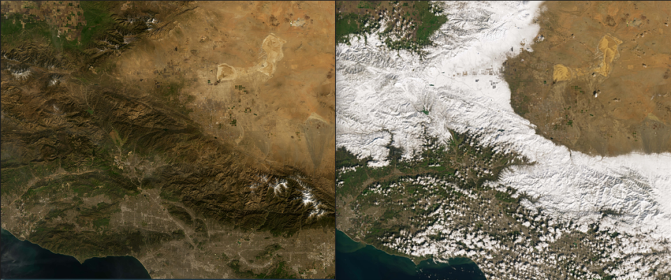
The images, captured by a NASA satellite, show the state on Jan. 29, days before the storms hit, and again on Feb. 10 after they subsided.
The first image shows clusters of white throughout the state, while the second image reveals the areas now blanketed in snow.
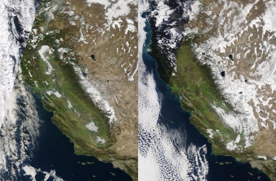
On Jan. 31, snowpack in Central Sierra was 53% of normal, while Southern Sierra was at 36%, data from the California Department of Water Resources shows. As of Feb. 14, those numbers are at 70% and 69%.
It is magical out here right now! #snow #CAwx pic.twitter.com/svCEuXg7jN
— UC Berkeley Central Sierra Snow Lab (@UCB_CSSL) February 5, 2024
“We received over 5 feet of snow in the last eight days,” Andrew Schwartz, lead scientist and manager at the Central Sierra Snow Laboratory told USA Today. “The snowfall over the last week has been the largest of this season and has helped bulk up our snowpack after a slow start to winter in terms of snow.”
This, however, still “pales in comparison to anything that we saw last winter,” Schwartz told the outlet.
Last season, winter storms likely pushed California to an all-time high, the Sacramento Bee reported.
State water officials announced last April the deepest snowpack ever recorded across the Sierra Nevada using automated sensors.
Southern California also saw huge amounts of snow last winter, McClatchy News reported.
Mountain High Resort saw nearly 8 feet of snow, Mount Pinos saw up to 6 feet of snow, and Mt. Wilson saw about 3 feet, McClatchy News reported last March.
Even with record-breaking seasons of snow, it’s still not enough, Schwartz told LAist. With climate change, the snowpack season is shortening.
“There is the fingerprint of climate change on everything that happens up here and the overall changes to our snow season,” Schwartz reportedly said.
And in the West, snowpack is considered critical, from drinking water to agriculture, National Geographic reported. A third of California’s water supply, for instance, comes from the Sierra snowpack.
This winter’s snow isn’t done just yet, though, according to the Central Sierra Snow Lab.
“We are expecting a total of 1-2 feet over the next 36 hours with more on the way this weekend and early next week,” the lab tweeted Feb. 14.
More rain is headed to Sacramento region this week. Here’s the latest forecast
‘Breathtaking’ satellite images show cyclone hurling storms at the West Coast. See them
Photos from space show how huge snowstorm blanketed Southern California. Take a look

