Satellite images show northern California covered in snow from atmospheric river

Satellite imagery from Nasa shows how an atmospheric river has covered the Sierra Nevada mountain range in snow during a series of storms.
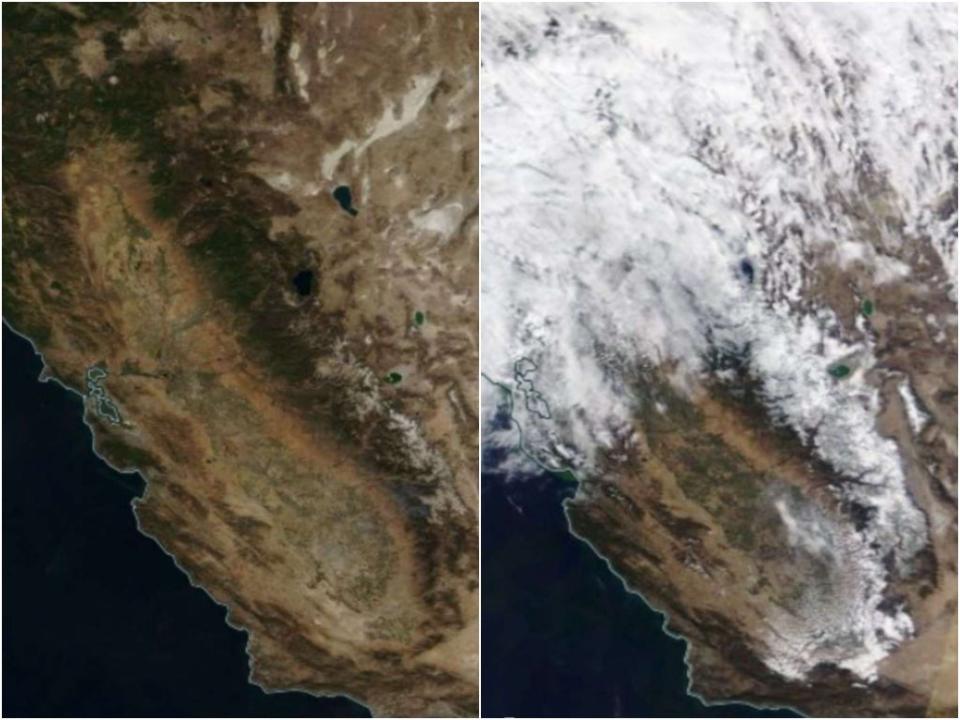
Images from the space agency’s worldview tool show the area in northern California dry on 16 October, with the mountains ladened with snow behind the clouds on 26 October.
A storm went through the region between Sunday and Monday, prompting early snowfall in the state. Almost three feet of snow fell in areas more than 7,000 feet above sea level in parts of the central and northern Sierra, SFGate reported.
Forecaster Hannah Chandler-Cooley at the National Weather Service in Sacramento said that it was “definitely impressive snowfall for late October”, but that “it really doesn’t tell us much about how the rest of winter will go”.
State climatologist Mike Anderson said that October’s rain and snow make up around 20 per cent of the “water year’s” total precipitation between 1 October and 30 September the following year.
“While this is a great start to the water year and much needed, it is a reminder that our wettest months (historically) are still ahead and are crucial that we get rain and snow in those months and throughout the year to really help end the drought,” he said in a statement.
Here are some snow totals for the recent storm over the northern Sierra. Snowfall amounts up to 3 feet were reported. #cawx #snow pic.twitter.com/azV2znpYTZ
— NWS Sacramento (@NWSSacramento) October 26, 2021
The snow in the Sierra during normal years is the source of around 30 per cent of statewide water when the snow melts in spring and is collected in reservoirs. But recent winters have been far from normal.
Indeed, the atmospheric river has left behind a historically significant October snowpack in the Sierra: https://t.co/d8jS3G0ugg
— Capital Weather Gang (@capitalweather) October 26, 2021
California’s Department of Water Resources found that on 1 April, when the snow is usually the deepest and holds the most water, the level of water was only 59 per cent of the average. Following that, 80 per cent of the estimated runoff water didn’t materialise. As the soil became dryer and the temperatures higher, the water was instead soaked up or evaporated, causing water levels in reservoirs to drop to drastically low levels.
Great news: This past weekend's massive atmospheric river gave the Sierra snowpack in CA a much needed makeover. Joy! pic.twitter.com/GJ1WKIhqdS
— Planet Diary (@PlanetDiary) October 28, 2021
Lake Oroville, a reservoir north of Sacramento, has risen by more than 20 feet since the start of the snow-bringing storms last week. But the Department of Water Resources website said on Tuesday that Lake Oroville was only at 27 per cent of capacity.
“We have much less accumulated precipitation over the past few years than we should normally receive and the soils are particularly dry — we cannot fix this condition with one storm,” Dr Anderson said.
The northern Sierra received between two and 20 inches of snow during the storm, with parts of the mountain range reporting higher figures.
The Associated Press contributed to this report
Read More
Caldor fire: Ski resort staff use snow guns to tackle blaze at Lake Tahoe
What is the Paris Agreement and why has Biden rejoined the climate pact?
What are Joe Biden’s plans to fight climate change?
CopP26 cruise ship to run on fossil fuels despite ability to use clean onshore energy

