Satellites watch as wildfires rage across Greece (photos)

The relentless wildfires in Greece can be seen from space as the blazes rage across the islands of Rhodes, Corfu and Evia.
The wildfires started last week on July 17. Authorities suspect arson may have caused the initial blaze, which has since been fueled by high winds, ongoing heat waves and subsequent dry conditions. Tens of thousands of people have since been ordered to evacuate the islands during peak tourism season.
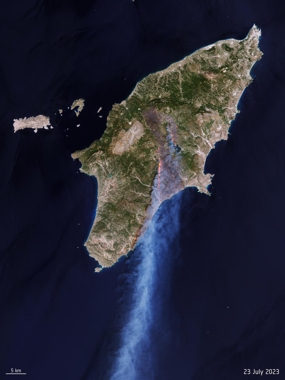
Data from multiple Earth-observing satellites have captured the fires as they've spread across the Greek islands. The Copernicus Sentinel-2 mission — a joint program run by the European Union (EU) and European Space Agency (ESA) — photographed the fires on Rhodes on July 23.
Related: Satellite photos show US East Coast engulfed by smoke from Canadian wildfires
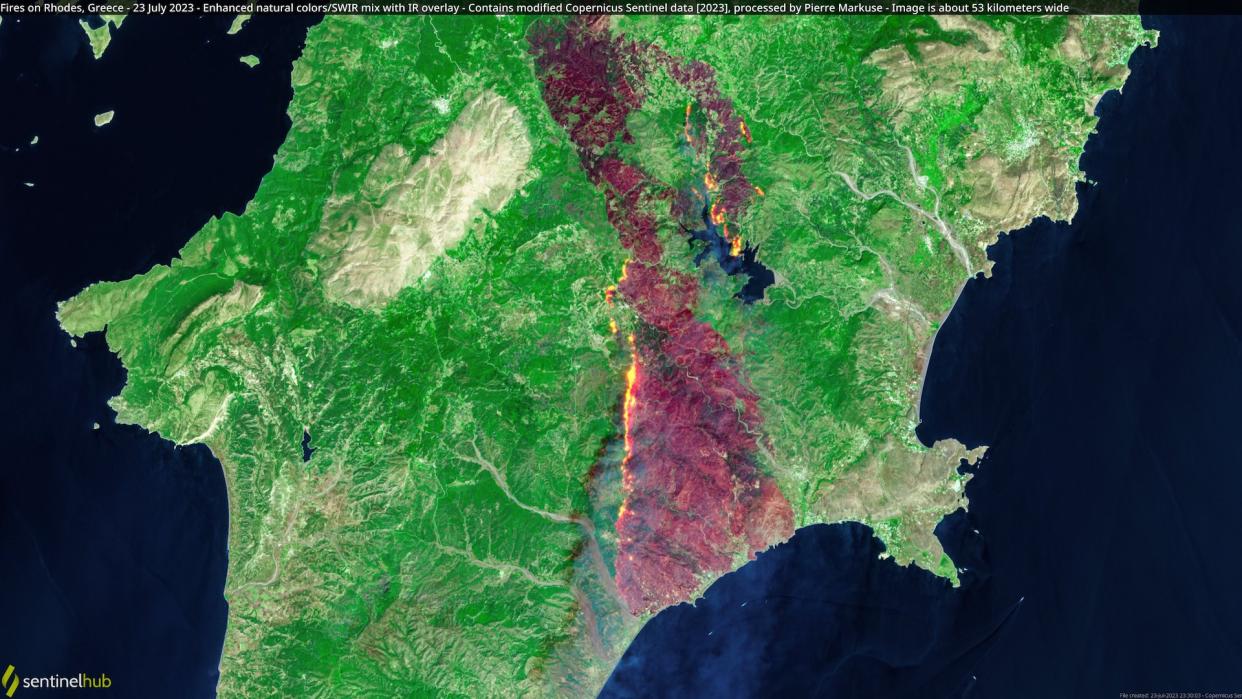
Satellite image processor Pierre Markuse shared two enhanced natural color views of the fires on Twitter, showing glowing flames spreading from the island's mountainous region to its coast, along with billowing clouds of smoke in the sky. The images are about 33 miles (53 kilometers) wide, according to Markuse.
🟠 Fires🔥 on Rhodes, #Greece🇬🇷 - 23 July 2023 #Copernicus🇪🇺 #Sentinel-2🛰️ Full-size ▶️ https://t.co/ufQwoPii5h + https://t.co/eRwEKcguYu #RemoteSensing #OpenData #SciComm #fires #wildfire #Greecewildfires #Rhodes #rhodeswildfires Images are about 53 kilometers wide pic.twitter.com/PjlHXOXXFEJuly 23, 2023
Europe's Directorate-General for Defence Industry and Space (DEFIS) also shared an infrared view of the Rhodes wildfires, taken on July 23 by the Sentinel-2 satellites, which are equipped with a high-resolution MultiSpectral Instrument (MSI) that samples 13 different bands of light for monitoring changes in Earth's land and vegetation. The satellites are used to support a variety of services and applications, including land management, agriculture, forestry, disaster control, humanitarian relief operations, risk mapping and security concerns.
#ImageOfTheDayA massive #wildfire is raging in #Rhodes island, #Greece 🇬🇷Tens of thousands of people have been evacuated➡️The @CopernicusEMS #RapidMappingTeam has been activated (#EMSR675) ⬇️#Sentinel2 🇪🇺🛰️ image from 23 July showing the burn scar of the #RhodesWildfire pic.twitter.com/ZB7NsBzuyEJuly 24, 2023
The Sentinel-2 shortwave-infrared data was combined with natural color bands to highlight the fire front and the extent of the burned area, which are represented by the brown swaths of land in the central part of the island. Officials estimate 11,000 hectares of land have been impacted by the fires, according to a statement from ESA.

"Air temperatures over the past week have exceeded 40 degrees Celsius [104 degrees Fahrenheit] in many parts of Greece. In addition to Rhodes, wildfires are also burning near Athens and on the island of Corfu," ESA officials said in the statement. "In response to the fires, the Copernicus Emergency Mapping Service was activated. The service uses satellite observations to help civil protection authorities and, in cases of disaster, the international humanitarian community, respond to emergencies."
Extraordinary images coming from the devastating #Greecefires 🇬🇷 over the last few days where many areas are experiencing high temperatures.Below: images from space via the #Copernicus #Sentinel2 satellite near Athens on 19 and 23 July show their impact. pic.twitter.com/up6ja7ylvMJuly 24, 2023
The European Organization for the Exploitation of Meteorological Satellites (EUMETSAT) shared a zoomed-in view of the wildfires taken by the Sentinel-2 mission on Twitter. The images show the devastating impact the fires have had near Athens between July 19 and July 23. Large areas of land are burned and massive, thick clouds of smoke fill the sky.
EUMETSAT also shared views from Europe's MTG-I1 weather satellite, which captured an impressive time lapse of the fire and smoke on the island of Rhodes. The organization shared the time lapse on Twitter on July 24, taken from a higher geostationary orbit 22,369 miles (36,000 km) above the equator.
The catastrophic fires in #Rhodes are clearly visible from space here, as #MTGI1 observed their resulting large smoke plumes on Saturday. Please note: this is preliminary commissioning data. pic.twitter.com/fY9aJAiWUqJuly 24, 2023
RELATED STORIES:
— Smoke from Canadian wildfires chokes US Midwest, reaches Europe (satellite photos)
— Climate change: Causes and effects
— NASA searches for climate solutions as global temperatures reach record highs
The MTG-I1 satellite (which stands for Meteosat Third Generation) launched on Dec. 13, 2022, and is the first of six satellites that will provide critical data for weather forecasting.
As the fires spread rapidly across the three Greek islands, thousands of residents and tourists moved to temporary shelters or evacuated on private boats over the weekend, resulting in the nation's largest wildfire evacuation in history, according to the Ministry of Climate Change and Civil Protection.

