The savage heart of hurricane season begins now. Here's what to expect.
August always arrives with a whiff of impending disaster. Fourth-graders who have eschewed summer reading in favor of Roblox must hastily identify the setting and main characters of "The Giver" by Lois Lowry.
Miami Dolphins fans attempt to stay positive while knowing yet another eight-win season lies ahead. Many are once again completely unprepared for the existential terror of National Clown Month. And of course, we all must reckon with the imminent, savage heart of hurricane season.
Our recent hurricane track record has not been good ...
Like the setting of "The Giver," recent hurricane season peaks have been downright dystopian.
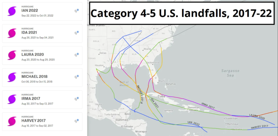
Six Category 4 or higher landfalls have overwhelmed the Gulf Coast over the last seven years; all six struck between late August and early October, the chaotic two-month period into which two-thirds of historical U.S. landfall activity is crammed.
All told, the last three years have brought a numbing 26 total named storm and 11 hurricane landfalls, tallying $235 billion in U.S. damages.
... but it's been a largely landfall free season so far ...
So far, the 2023 season has been a nice reprieve, at least in terms of U.S. impacts.
While there have already been five storms racking up about three times normal activity to-date, these systems have had the uncommon decency to avoid the U.S. coastline. That’s fortunate indeed, as about 60% of seasons have a U.S. impact from a tropical storm or hurricane before August.
However, past performance does not predict future results: there is no relationship between U.S. landfall activity prior to August and how many landfalls occur in the rest of the season.
An early season hurricane doesn’t mean more are coming in the peak months, and vice versa. For overall activity, a busy August in the Atlantic corresponds to only a marginal increase in the odds of an active September and October, while June and July, like Jim Cramer, have no predictive power.
... but the odds of a normal season are shifting away from our favor
Will our early luck hold out?
If you’ve read WeatherTiger’s previous seasonal outlooks or follow our real-time probabilities, you know it’s hard out here for a seasonal hurricane forecaster. The two most reliable predictors of tropical activity, Atlantic sea surface temperatures (SSTs) and El Niño/La Niña, suggest divergent outcomes for the 2023 hurricane season. That chasm expanded further this summer, and is now the size of the gap between the palettes of "Barbie" and "Oppenheimer."
WeatherTiger’s real-time seasonal forecasting algorithm has been making sense of this as best it can, though only a fool would be confident in what comes next.
As of early August, our model projects a most likely outcome of around 150 units of Accumulated Cyclone Energy (ACE), which is about 50% above the average season’s 100 ACE units.
That corresponds to a 30% to 35% chance each of a hyperactive (>165 ACE), above average (125-165 ACE), or near normal year (73-127 ACE), and a less than 5% chance of a below normal (<73 ACE) season. These odds may continue to shift as the peak approaches, and you can monitor WeatherTiger’s daily ACE model runs in real-time at weathertiger.com.
This is a significant adjustment in the direction of more activity over the last two months.
AccuWeather: Forecasters predicting 13-17 named storms, up from previous prediction
Tropics Watch: National Hurricane Center tracking Invest 96L, 5 tropical waves. Quiet not expected to last
Why models are now calling for a more intense hurricane season
Our model has packed 50 ACE units onto its forecast since late May, including 15 ACE units that have already occurred, boosting the odds of an above average season from 25% to 35% and the chance of a hyperactive season from just 5% to 35%.
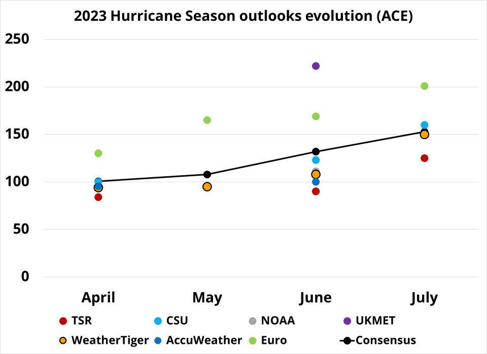
We’re not alone. Predictions from Colorado State, the European Center, and others have all been revised higher, and NOAA and additional groups may follow suit in the next week.
You might think that the cause of that change is another predicted El Niño event failing to launch, but that’s not the case.
El Niño got rolling as projected early in the summer and has since intensified to a “moderate” event, with water temps averaging more than 1°C above normal in the Equatorial Central Pacific and models projecting more strengthening to come.
El Niños create storm-shredding upper-level wind shear over the Caribbean and Gulf, and mean fewer Atlantic hurricanes. While El Niño’s grip on the world’s weather is not ironclad yet, wind shear in the Caribbean was stronger than average in July, as expected. These shearing winds tend to persist once established, which is one continued argument for a milder season.
The issue is Atlantic sea surface temperature anomalies have gone from ridiculous to sublime in the past two months.
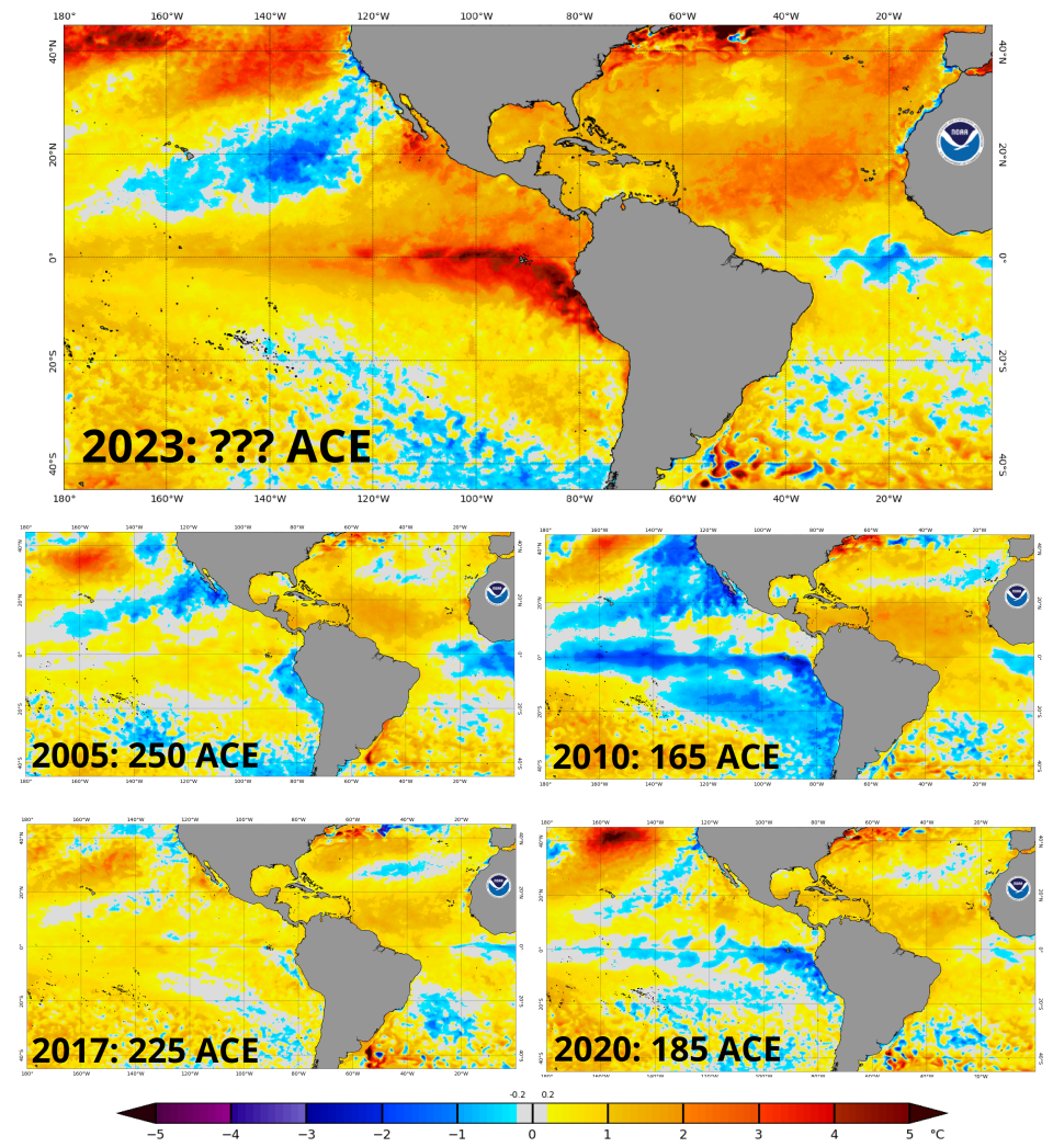
Summer water temps between Central America and West Africa and north toward western Europe are a top predictor of seasonal activity, and this year we saw all-time record warmth in June, and the June-July average is almost certainly above the recent benchmarks set in 2005, 2010, 2017, and 2020. Those four years averaged almost double the Atlantic tropical activity of a normal season.
Yet bringing the Pacific back into the fold, none of those years are strong analogs. Each of those four seasons had either a mature or developing La Niña, which acted to also keep the upper-level winds in the Atlantic more favorable for hurricane activity than normal.
So, when the Atlantic is this hot, hurricane seasons are above normal or hyperactive. When the Pacific is this hot, hurricane seasons are near or below normal. Earlier, WeatherTiger’s model was calling for a draw, but is now projecting that the Tropical Atlantic is so warm that the thermodynamic runaway train will win out over unfavorable upper-level winds, and it will be a busy season.
And maybe that is true. It wouldn’t surprise me, and we should be prepared for it as individuals and as a society. But the internal model signals are deeply mixed, and as a seasonal hurricane forecaster, I’m skeptical of the utility of seasonal hurricane forecasts this year. None of the techniques were designed to work this far outside the normal range of variability of key inputs, so the potential for large forecast errors is higher than usual.
The final analysis
If I had to pick, I’d take the under on WeatherTiger’s own model. Hurricanes form when all the necessary meteorological conditions for development are in place, not just some of them, and very busy seasons happen when those raw ingredients are consistently present in August, September, and October. Given the robust El Niño, predicting a hyperactive hurricane season in 2023 feels a little like saying you can bake a cake without flour by turning the oven up to 700°.
Overall, 2023 is simply off in its own universe, where the Atlantic is hot, the Pacific is hot, UFOs clog the skies and no one cares, and superconductors work in a sauna but only on the Internet.
It’s a lot, and recent experiences have not built trust we’re heading anywhere good. Objectively, odds of an active season have risen, but there’s a lot going on beneath the surface.
Next week, I’ll discuss WeatherTiger’s U.S. landfall modeling, and where hurricanes might predominantly form and track this year in part two of our outlook. In the meantime, kids, remember to impress your teacher by putting your summer reading book report in a professional clear plastic binder, and keep watching the skies.

Dr. Ryan Truchelut is chief meteorologist at WeatherTiger, a Tallahassee start-up providing forensic meteorology and expert witness consulting services, and agricultural and hurricane forecasting subscriptions. Get in touch at ryan@weathertiger.com, and visit weathertiger.com for an enhanced, real-time version of our seasonal outlook.
This article originally appeared on Tallahassee Democrat: Hurricane forecast: Why models are pointing to a more active season

