Scary roads ahead. Freezing fog, mix of rain and snow in Tri-Cities forecast
Just about every kind of weather than can make roads slick are forecast at some time on Thursday in the Tri-Cities.
The Tri-Cities will start Thursday under a freezing fog advisory until 7 a.m., followed by a possible wintery mix of rain and snow.
Then National Weather Service says rain and snow are likely before 1 p.m., with precipitation turning to rain in the afternoon.
But a rain and snow mix could return as temperatures cool after 4 p.m. A chance of rain and snow is forecast until early Friday morning.
Any snow accumulation will likely be less than a half inch, according to the weather service.
Temperatures will warm slightly with the storm system, but highs will remain below normal. The high Thursday could be 35, with the temperature dropping to 26 Thursday night.
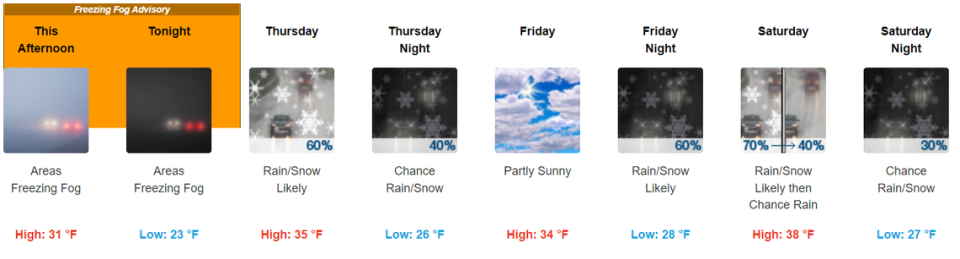
The mix of rain and snow is expected to return Saturday morning before 10 a.m. But with the Saturday high forecast at 38 in the Tri-Cities, snow is likely only at higher elevations in the Tri-Cities area.
Sunday could also see rain and snow, but the forecast says it is less likely than on Saturday.

The coming work weeks should start out dry under mostly cloudy skies. No precipitation is forecast through at least Wednesday.
But temperatures will be dropping again. The low Tuesday night could be only 18, and the high Wednesday could get no warmer than 27, according to the weather service.
Normal average highs for early to mid December in the Tri-Cities are 42 degrees and normal average lows are 28.

