Searching for clues about RI's early settlers on a walking tour of 5 Exeter cemeteries
EXETER — Freelove Rathbun (1762-1850) and her husband, Rowland Rathbun (1766-1826), rest side by side on a hillock under the shade of cedar trees just above a tiny, stream-fed pond where ducks glide over a smooth-as-glass surface.
I’d never seen the small cemetery before, despite passing close by many times on nearby trails that run through the 14,000-acre, state-owned Arcadia Management Area.
I finally found the site when a guide took me on a recent walk to see five historical graveyards that time has all but forgotten.
The visits helped me realize that the remote, now-uninhabited woodlands were populated hundreds of years ago by early settlers, farmers and their families. Each farm had its own cemetery, where parents, children and other family members were buried. Near the gravesites, you can still see the cellar holes, barn foundations and wells that they built.
Hiking: These 10 Rhode Island trails should be on your bucket list
Walking RI: 5 R.I. waterfalls worth a walk
How many historical cemeteries are in Rhode Island?
By one estimate, there are 3,000 historical cemeteries in Rhode Island, including more than 170 in Exeter and another 1,000 that are lost under weeds, briars, leaves and downed trees.
Each graveyard tells its own story — as I learned on my walk.
I set out on an early spring morning with my guide, Dory Wagner, the historical cemetery coordinator for Exeter and Richmond. We parked off Escoheag Hill Road near a red log cabin that was built in the 1930s by the Civilian Conservation Corps, the federal jobs program created by President Franklin Delano Roosevelt during the Depression, and that more recently has served as a deer hunters’ check station.
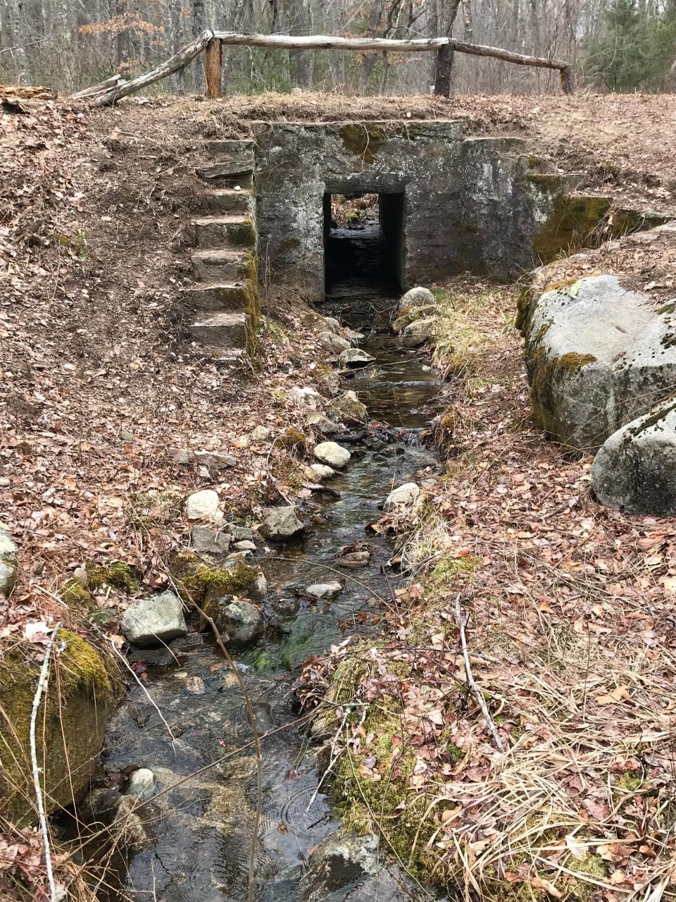
After passing a locked gate at the entrance of Plain Road (also known in sections as Austin Farm Road), we headed downhill on a wide, gravel road. In about a quarter mile, the road forks at an impressive, stone-lined culvert that carries a fast-running stream under the roadway.
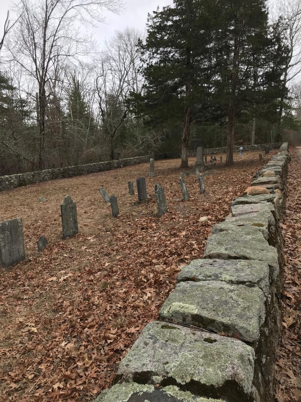
We turned right on Barber Road and soon came to a large, well-kept cemetery that the Rhode Island Historical Cemetery Commission lists as No. 3.
Walking RI: 5 great hikes with ocean views
Walking RI: Up for a challenge? Tippecansett South Trail is a rigorous, rewarding workout
Status in life is mirrored in cemetery
The 165-by-60-foot graveyard is enclosed by a well-preserved, 4-foot-high rectangular stone wall. The wall and the remains of an iron gate indicate the families buried here were wealthier than others. There are 28 marble, slate and granite stones of different sizes, with rounded or squared tops, that are inscribed with names and dates from earlier eras. Some are carved with urns and willows. The smallest stones were for children, many of whom didn’t survive the year of their birth.
The biggest marker, a four-sided marble obelisk, is carved with the names and lifespans of Jonathan Rathbun (1770-1850) and his wife, Judith (1775-1800).
Rathbun was a descendant of John and Margaret Rathbun, who emigrated to America from England in the mid-1600s. They lived on Block Island for a while before family members moved to the mainland. Some settled in northwest North Kingstown before it became Exeter. The family grew, and by the mid-1700s, records show that 50 Rathbuns lived in Exeter.
The Rathbuns were mostly farmers who raised cows, hogs and geese on farms that included barns, outbuildings, pastures, gardens and orchards. Some Rathbuns were blacksmiths, weavers, millers and shoemakers. Others served in public office.
Walking RI: Find peace on a hike at Cumberland preserve once owned by Sisters of Mercy
Walking RI: Want a great place for an educational family hike? Try Browning Woods Farm in S. Kingstown
We inspected the stones, and others in an adjoining cemetery (No. 74), where Ira Wilcox (1821-1867), his wife, Sally Rathbun Wilcox, and other family members are buried.
Outside the graveyard in the woods, we found a stone slab threshold next to a cellar hole with a crumbled fireplace at one end.
Retracing our steps on the road, we took a right on an old farm lane and passed a three-sided structure on the left, probably a barn or stable, with a 30-foot-wide opening and 8-foot-high stone walls. The roof is long gone.
More: Gravestones tell a lively story about Westerly granite on Amy Russo's cemetery tour
Murder, myth, devotion: Stories from Providence's North Burial Ground
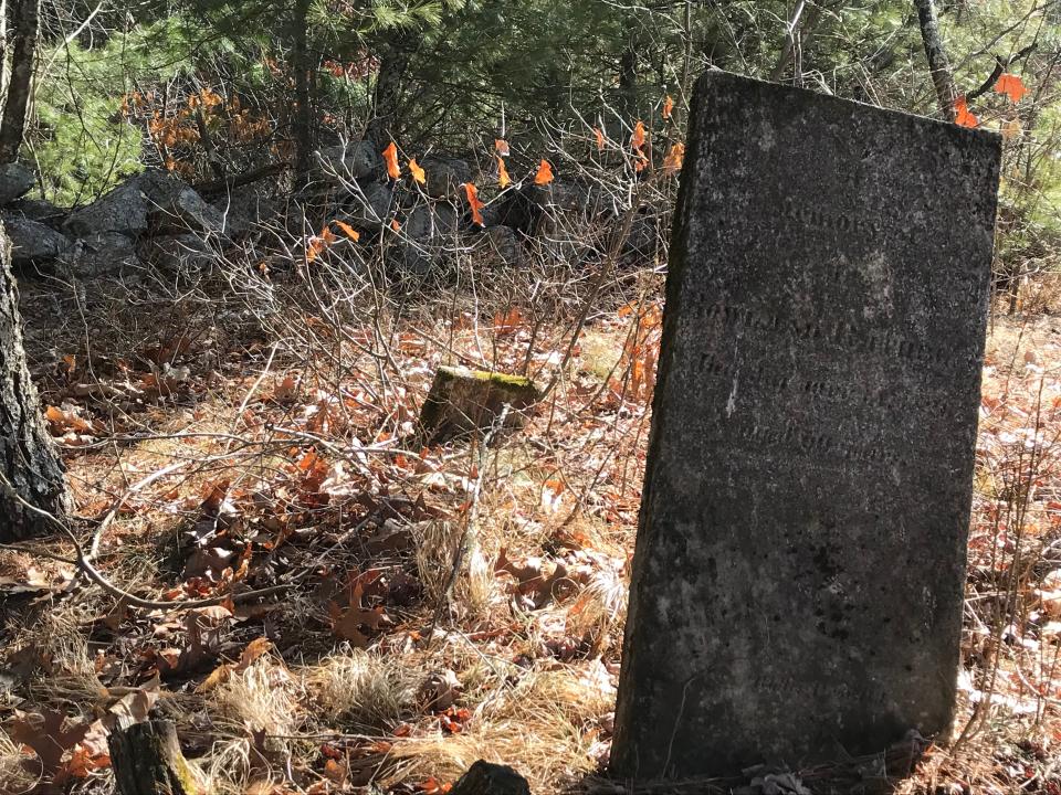
A more humble graveyard, with stones dating back to Colonial era
The farm lane was partially overgrown and crossed at times with downed trees, but we had little trouble reaching Plain Road. We turned right and walked downhill until Wagner found a footpath on the right that led up a hillside to Cemetery No. 75.
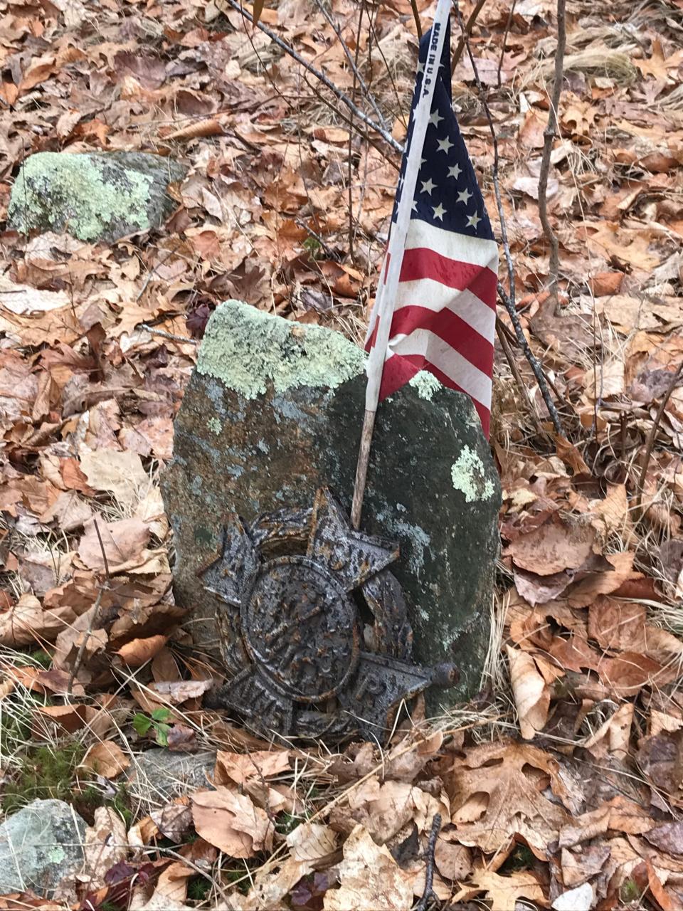
Unlike the Rathbun cemetery, this one had no stone-wall enclosure and some of the headstones were buried under leaves. Some of the crudely inscribed fieldstones are impossible to read. A single slate headstone, marked for Ann Perkins (1801-1822), had shattered and been pieced back together. An American flag had been placed near another small stone that had an iron marker stamped with 1775.
Walking RI: See rugged coastline and 100-year-old ruins at Narragansett's Black Point
We returned to Plain Road and just before reaching the Falls River, we turned right on a trail that follows sections of the white-blazed Escoheag Trail and the blue-blazed North South Trail, which runs north for 78 miles from Blue Shutters Beach in Charlestown to the border with Massachusetts in Burrillville.
The flat trail ran under tall, thick pine trees and passed a turnoff on the right for the Escoheag Trail. To the left, there’s a valley and then a ridge that hides the Falls River, which flows southeast and merges with the Flat River to form the Wood River. We followed the easy North South Trail that crossed a bridge and then rose on a gentle incline. Just before reaching Barber Road, there’s a set of stone walls, an earthen berm that may have been created to hold back water and the remains of a building foundation.
Walking RI: Take a refreshing winter hike by a peaceful stream at Tucker Woods Preserve in Charlestown
At Barber Road, we turned left at an opening through some green-bladed yucca plants and walked down a side path by the remains of cellar holes above a large field that some have identified as the remnants of the C.H. Barber Farm.
We returned to Barber Road and walked downhill about a hundred yards to an opening at a red-bar gate. We walked by the gate and crossed a huge, mowed hay field where the Rhode Island Department of Environmental Management stocks pheasants and grows grasses and cover crops.
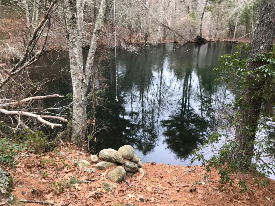
Freelove and Rowland Rathbun, side by side for eternity
Beyond the field is a white sign for Cemetery No. 112, just before the mound where Freelove, a daughter of Zephania Brown, and Rowland Rathbun, a son of John Rathbun, are buried. His marble stone is badly tilted while her headstone has fallen and lies flat face up in the earth. The inscriptions are barely legible. At the base of Rowland’s stone is the name of the carver, Bolles, who worked out of Providence.
Each grave has a footstone that is engraved with the initials of the person buried there. Wagner explained that the footstones at most historic graves are placed at a distance from the headstone that equals the height of the person.
The tiny graveyard is circled by a broken, uneven stone wall. At an opening, a path leads downhill to the tiny pond. We walked along the banks and found a rope swing and a fire ring. We also noted that the far bank is a manmade dirt berm probably built to form the pond.
Walking RI: A step-by-step guide to beautiful Stepstone Falls
After spending some time thinking about the Rathbuns’ burial plot on a quiet, beautiful site, we returned to Barber Road and turned right to walk up the hill. We passed more stone walls, cellar holes and wooden fences at side cuts where horses and their riders can stop and rest.
Why are graves laid out on an east/west orientation?
At the crest of the hill, the Mount Tom Trail opens on the left, but we turned right and walked downhill on a continuation of the Escoheag Trail. A side path on the left leads to Cemetery No. 165, a small graveyard of about 10 unidentified fieldstones that was found recently by archeologists exploring the area. As in many old cemeteries, the graves are laid out on an east/west orientation to follow the belief that, at the Redemption, the deceased would be able to sit up and look to the east at the rising sun.
Walking RI: This Hopkinton RI trail was featured in Wes Anderson's 'Moonrise Kingdom'
Walking RI: Over the rivers and through the woods on Mount Tom Trail
We returned to Barber Road, passed an area on the left scarred by the spongy moth infestation a few years ago and reached the intersection with Plain Road. We headed back to where we'd parked after walking 4 miles over three hours — with many stops.
Wagner and other volunteers lead walks to the old cemeteries, and the Rhode Island Advisory Commission on Historical Cemeteries and the Rhode Island Historical Preservation & Heritage Commission sponsor dozens of free tours, cleanups, talks and other programs in April and May.
For a calendar of events, visit preservation.ri.gov/ricw-calendar.
I’ve hiked in Arcadia dozens of times, but my walk to the old cemeteries just off the trails gave me a better understanding of the history of the state and the Rhode Islanders who lived here hundreds of years ago. It was a good reminder that you can learn some amazing things when you get off the beaten path.
If you go ...
Access: Off Route 165 west, take Escoheag Hill Road north for one mile to the Escoheag Trail trailhead on the right, next to an old log cabin.
Parking: Available in a lot.
Dogs: Allowed but must be leashed.
Difficulty: Easy to moderate, on gravel roads and some rocky ridges.
Trail Tip: More information on historical cemeteries
Search for historical cemeteries in this database maintained by the Rhode Island Historical Cemetery Commission: rihistoriccemeteries.org/webdatabase.aspx
Read about Exeter graveyards in, “Exeter, Rhode Island Historical Cemeteries,” a book by John Sterling and James Good.
The Walking Rhode Island column runs every other Sunday in the Rhode Islander pages. John Kostrzewa, a former columnist and assistant managing editor/business at The Providence Journal, welcomes email at johnekostrzewa@gmail.com.
This article originally appeared on The Providence Journal: Learn about Rhode Island history during hike through Exeter cemeteries

