Unusual train of snowstorms to keep targeting Seattle this week
After a winter's worth of snow brought major disruptions to the Seattle area this past weekend, the unusual train of snowstorms will continue this week with record cold bringing more hazards.
The biggest snowstorm since February 2017 brought 6-10 inches to the area from Friday afternoon to Saturday morning.
With a total of 14.1 inches, this month is now the Seattle's snowiest February on record.
Sea-Tac airport Feb. snow total 14.1", a new monthly February record. Old record 13.1" in 1949. Top 8 snow months at Sea-Tac.
1. 57.2" Jan 1950
2. 45.4" Jan 1969
3. 22.1" Dec 1968
4. 20.0" Jan 1954
5. 18.2" Mar 1951
6. 17.5" Nov 1985
7. 15.3" Dec 1965
8. 14.1" Feb 2019. #wawx— NWS Seattle (@NWSSeattle) February 11, 2019
The cold, snowy weather shifted southward on Sunday and Sunday night, snarling travel over the Grapevine and causing a rare snow event in Las Vegas.
Continued cold will set the stage for more snow events for the Northwest, including Seattle.
A storm on Sunday night dropped another 2 inches of snow around the city.
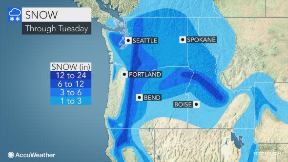
As quick as this snow event ends, the next in the storm train will follow and target Seattle with 3-6 inches Monday afternoon through Tuesday.
Residents will be faced with more major disruptions to travel and daily routines, including an extended stretch of school closures.
Motorists should prepare for slippery to slow and difficult travel. Even when there is a break in the snow on Monday morning, slick conditions can plague commuters as crews work to clear roads.
Flight delays and cancellations can mount during the Monday evening commute as the snow sweeps back across the city.
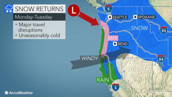
Travel hazards and disruptions will not just be limited to Seattle and surrounding areas. The rounds of snow into early week can also target Portland, Bend and Pendleton, Oregon; and Yakima and Spokane, Washington.
Download the free AccuWeather app to know how much snow is expected in your community.
Those planning to drive along I-90's Snoqualmie Pass in Washington and I-5's Siskiyou Summit should prepare for difficult travel and potential restrictions.
The upcoming storms can produce less wind and blowing snow in Washington as the gusty winds and added travel hazards focus on areas from Oregon and Northern California to southern Idaho.
More cold and record-challenging lows can follow around midweek as western Washington and northwestern Oregon catch a break from the onslaught of winter storms.
However, there can be yet another snow or wintry mix event for the Seattle area if the cold remains in place when another storm arrives later this week.
It is not rare for snow to fall in Seattle during the winter months, but it is rare to have multiple storms bring high amounts of snow over a short period of time.
"The snowstorm spanning Friday night to Saturday morning was the second of this month in Seattle," according to AccuWeather Senior Meteorologist Brett Anderson. The first week of February started with 3-8 inches of snow in the Seattle area.
The city experienced their third storm on Sunday night.
"A fourth storm will follow early this week," Anderson stated. "I do not remember a pattern like this."
Typically, Seattle receives two to three snow events a year, or about 7 inches of snow annually. However, this can vary from little or no snow in some years to more than a foot in snowier winters.
With over 14 inches recorded so far, this winter is now the snowiest winter at the city's airport since 2008-09, when a total of 22.0 inches fell.
Few things reflect the power of nature and weather like avalanches. This week host, Regina Miller talks to Mark Staples, director of the Utah Avalanche Center, and Dan Burnett, Group Mission coordinator for the Summit County Rescue Group in Breckenridge, Colorado. They discuss recent deaths on the slopes, the weather situations that can contribute to an avalanche, the dangers of human interaction, and how best to survive.

