Winter travel advisories remain in place for Wednesday morning's commute
November is now showing southern Ontario that winter is closer than you think, offering the region including the Greater Toronto Area (GTA) a sneak peek of the season this week. In addition to the plummeting temperatures, multiple shots of snowfall are creating tricky travel through the Wednesday morning commute. Some areas are forecast to see 10 cm of snow by the time all is said and done. A widespread winter weather travel advisory remains in effect, warning drivers to prepare for quickly changing and deteriorating travel conditions.
See what you'll need to prepare for, below.
Wednesday morning: Expect slower travel after overnight now
We have officially hit the mid-November mark and early winter-like weather will be hard to miss across southern Ontario this week.
Tuesday saw snow squalls pop up around the Greater Toronto Area (GTA), leading to difficult travel and quick accumulations.
Impressive lake effect snow streamer into Toronto and other parts of the GTA such as Mississauga and SW Vaughan.#ONStorm pic.twitter.com/w7vIOKvCc8
Impressive lake effect snow streamer into Toronto and other parts of the GTA such as Mississauga and SW Vaughan.Tom Stef on Twitter: "Impressive lake effect snow streamer into Toronto and other parts of the GTA such as Mississauga and SW Vaughan.#ONStorm pic.twitter.com/w7vIOKvCc8 / Twitter" Tom Stef on Twitter: "Impressive lake effect snow streamer into Toronto and other parts of the GTA such as Mississauga and SW Vaughan.#ONStorm pic.twitter.com/w7vIOKvCc8 / Twitter"
— Tom Stef (@vaughanweather) Tom Stef on Twitter: "Impressive lake effect snow streamer into Toronto and other parts of the GTA such as Mississauga and SW Vaughan.#ONStorm pic.twitter.com/w7vIOKvCc8 / Twitter"
SEE ALSO: Toronto sets a new record for latest date below 0°C
That wasn't it for the snow, either. A low-pressure system making its way over Lake Erie Tuesday evening, brought more widespread snow for much of southern Ontario, with many areas waking up to several centimetres of it early Wednesday morning.

Typical of mid-November events, temperatures will be marginal with accumulations highly impacted by elevation and distance from the Great Lakes. Because this is the first measurable snowfall of the season however, drivers are being urged to use extra caution.
"Be prepared to adjust your driving with changing road conditions. Slow down driving in slippery conditions. Watch for taillights ahead and maintain a safe following distance. Visibility may be suddenly reduced at times in heavy snow," says Environment and Climate Change Canada (ECCC) in the winter weather travel advisory.
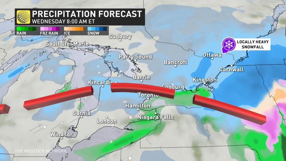
Snow will also impact the morning commute on Wednesday in the GTA, so plan ahead and allow for extra time to reach your destination. The snow is expected to taper to scattered flurries later this morning.
WATCH: Snow to bring tricky travel in southern Ontario through Wednesday
DON'T MISS: Icy weather is inevitable. Here's what you need to prepare
Meanwhile, widespread below seasonal conditions are set to dominate this week and beyond, with another reinforcing shot of Arctic air and temperatures more typical of early December at times.
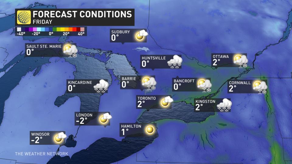
Temperatures on Friday and Saturday will be more typical of early to mid-December. Blustery conditions will end the week along with another round of lake-effect snow in the snowbelts.
Significant lake-effect snow squall event to come
Lake-effect snow squalls will linger through the weekend and into early next week. This will be a high-impact, multi-day event.
"This will [hinder] travel for the highest impacted areas east of Georgian Bay and Lake Huron, especially near the Bruce Peninsula and from the Gravenhurst area to north of Parry Sound," says Dr. Doug Gillham, a meteorologist at The Weather Network.
The hardest-hit regions could be the Buffalo and Watertown areas, with the potential for snow totals between 50-80+ cm.
It's officially mid-November and we're wondering: Have you made the switch to winter tires yet? ❄🚗 #TWNPoll
It's officially mid-November and we're wondering: Have you made the switch to winter tires yet? ❄🚗 The Weather Network on Twitter: "It's officially mid-November and we're wondering: Have you made the switch to winter tires yet? ❄🚗 #TWNPoll / Twitter"
— The Weather Network (@weathernetwork) The Weather Network on Twitter: "It's officially mid-November and we're wondering: Have you made the switch to winter tires yet? ❄🚗 #TWNPoll / Twitter"
"We will closely watch southern parts of the Niagara region as the heavy snow squall could drift north into this region at times, especially Thursday night and Friday and again Saturday night into Sunday," adds Gillham. Between 30-50 cm of snow is possible between Niagara Falls and Fort Erie."
Thumbnail courtesy of @1Weathercanada/Twitter, taken in Kitchener, Ont.
Be sure to check back for the latest weather updates across Ontario.

