Relief looms for wildfire-stricken B.C., Alberta, but comes with storm risk
There appears to be some help coming this weekend for firefighters battling the wildfires in B.C. and Alberta.
The Victoria Day long weekend will kick off with poor air quality and an extreme fire danger, but a decent chance for rain during the second half of it could bring much-needed relief to some of the hardest-hit communities. However, there will be a chance for thunderstorms all three days of this long weekend as a stretch of unsettled weather begins to build in the West once again.

RELATED: Alberta air quality among worst in the world due to wildfire smoke
With the threat of storms with lightning on the table, fears over new wildfires will be present. Some of the storms could turn severe, potentially ruining Victoria Day plans with fireworks from Mother Nature.
Saturday
A weak, slow-moving disturbance stateside will provide enough of a thunderstorm trigger. On Saturday, a thunderstorm threat unfolds, isolated in nature, but extending across B.C. and Alberta through the afternoon and evening thanks to daytime convection and a weak disturbance stateside.
Severe storms could be possible, most likely within the Okanagan in B.C., with heavy downpours and small hail. Not everyone may see this activity, and if you don't, your forecast continues to be sunshine and above-average temperatures, climbing to the 30s once again across the B.C. Interior.
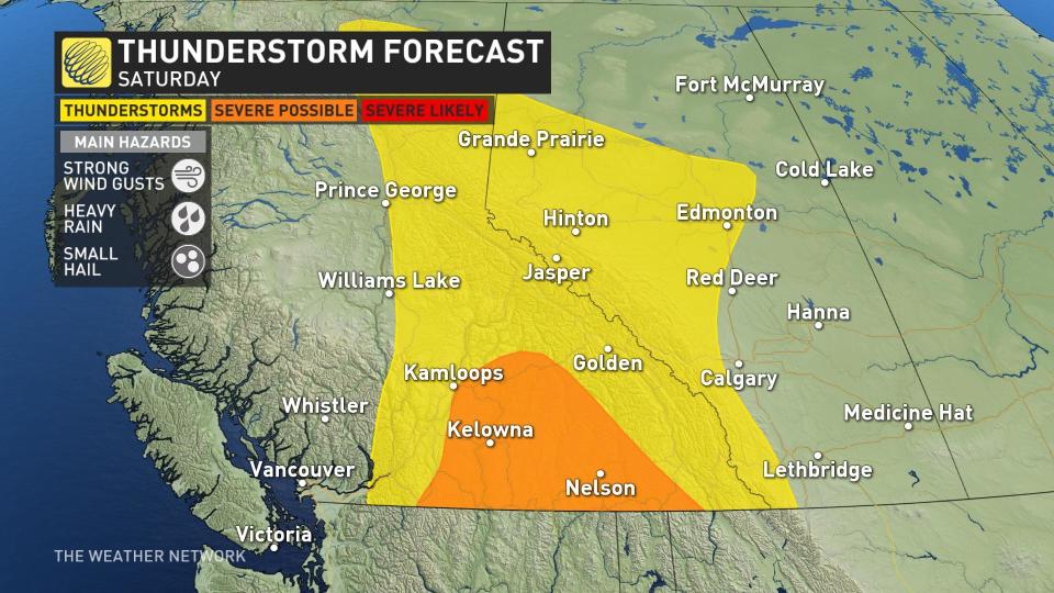
Some of the thunderstorms could reach severe limits, especially in the Okanagan in B.C., with strong wind gusts, heavy rain, and small hail possible in the most robust storms that take advantage of Saturday’s warmth.
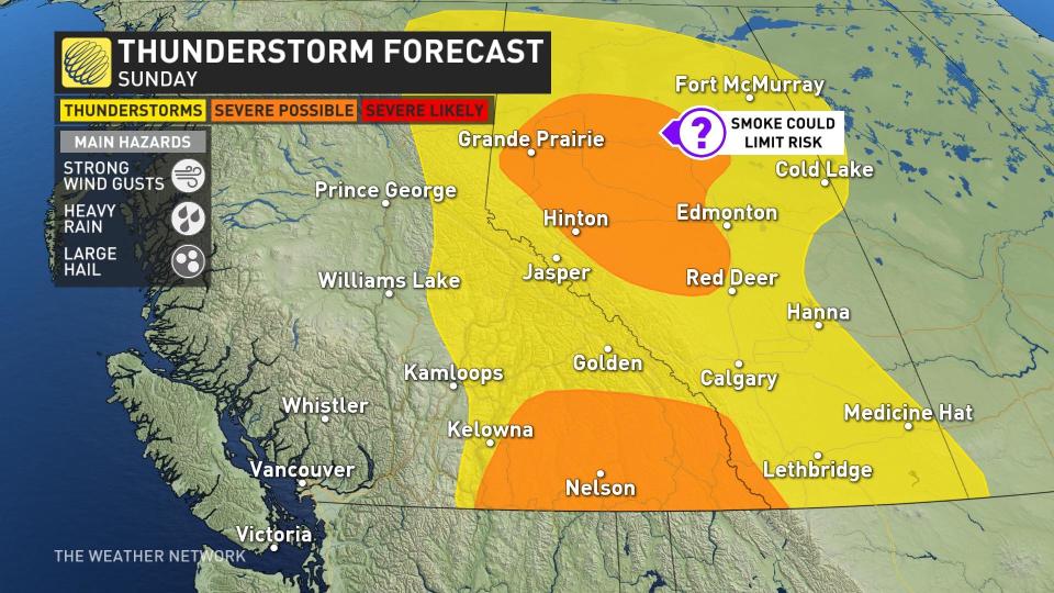
Sunday and Monday
Much of the same forecast spills into Sunday. Thunderstorm energy and threat exists in a very similar region. Shifting farther east and north will give Alberta more of a chance for thunderstorm activity, but wildfire smoke might limit the threat. Some storms west of Edmonton, Alta., could become marginally severe in nature with larger hail and strong wind gusts being the main threat.
Once again there is the chance for severe storms to pop up in B.C.’s southeast, where heavy downpours could interrupt campers and adventurers for a second day in a row.
Visit The Weather Network's wildfire hub to keep up with the latest on the active start to wildfire season across Western Canada.
An upper-level pattern change sweeping into Western Canada could bring a third day of thunderstorms to the western Prairies as a welcome round of precipitation arrives in areas hardest hit by the recent wildfires.
A trough over the Pacific will swing into the B.C. coast toward the end of the weekend and into early next week. An upper-level low developing off this trough will bring a round of significant precipitation and a break from the unseasonably hot temperatures roasting the region.
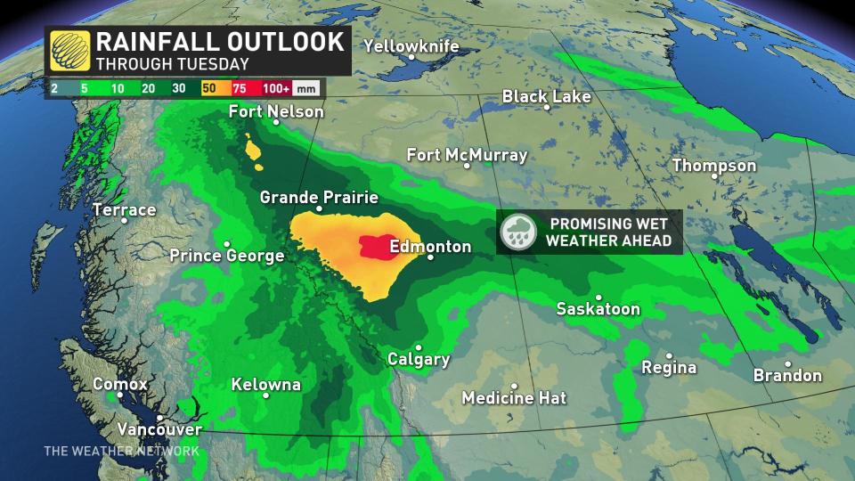
Forecasters expect widespread rainfall to begin Monday and last for at least a couple of days, stretching into mid-week.
Precise rainfall amounts and the exact locations benefitting from these much-needed rains will become clearer this weekend, but either way, this looks to be a positive step toward dampening ongoing wildfires and preventing more fires from breaking out.
Heavy rain over burn scars can create significant flooding risks. The burnt landscape can act as a water repellent, and the missing tree canopies increase the flooding threat, as well. Mud and debris flows can also be a hazard with the recently burned landscape.
Meanwhile, a trough will become stationary Monday into Tuesday over central Alberta, likely dropping 50 mm of rain in the wildfire-stricken regions that need it the most.
Temperatures on track to ease for a bit
Along with the rain, this upper-level shift will bring a break from the extended stretch of summer-like temperatures that’s caused so much trouble across the region over the past month.
Temperatures will remain above seasonal through the weekend before cooler, below-seasonal conditions temporarily move in early next week.
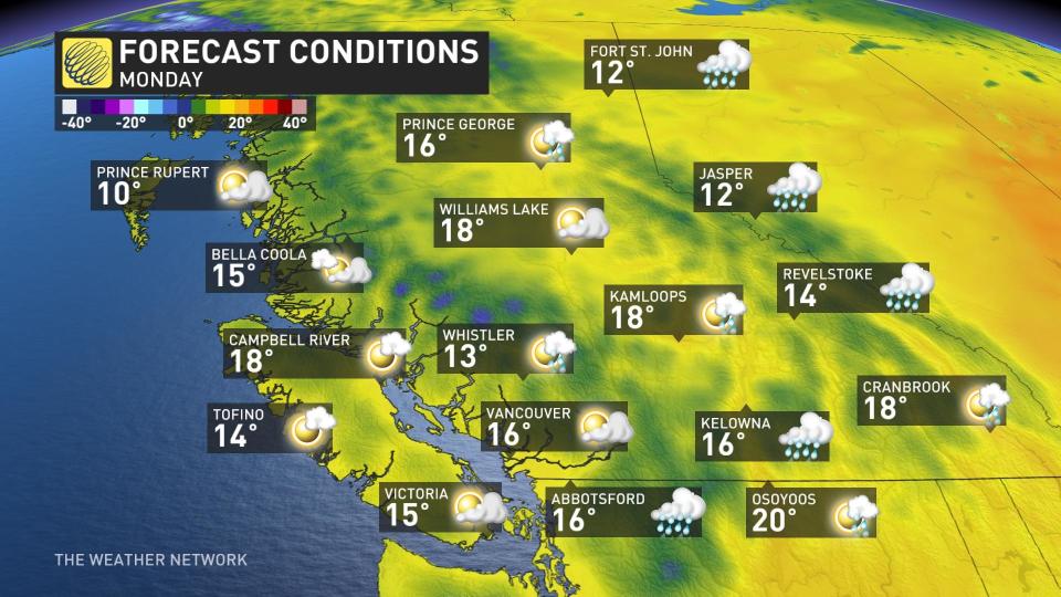
Much of B.C. and northern Alberta will see temperatures fall by 10+ degrees on Monday, with daytime highs in the mid- to upper-teens in the forecast for a couple of days. This cooldown will aid in wildfire management for the duration of the atmospheric break.
Temperatures will start to rebound by late next week, though, just in time for the arrival of meteorological summer.
Thumbnail image courtesy of Lee Asplund, taken in Brooks, Alta.
Keep checking back to The Weather Network for all the latest on conditions across Western Canada.

