Powerful storms to batter East and West coasts as California faces risk of flash flooding and snow
Two strong storm systems moved ashore on the East and West coasts simultaneously Monday night as California faced a fresh threat of flash flooding and heavy mountain snow.
The arrival of the "separate but potent" low-pressure systems has left 22 million people under winter weather alerts and will see both sides of the country slammed with severe weather, the National Weather Service said. Widespread precipitation was expected as a storm from the Gulf of Alaska moved over California's North Coast Monday evening.
At the same time, a nor'easter moving up the East Coast was bringing rain to Philadelphia as it was expected to strengthen offshore and transform into a snowstorm. Five New Jersey counties were under a weather-related state of emergency, and as much as a foot of snow was expected along Pennsylvania's I-80 corridor, according to the National Weather Service.
A National Weather Service forecast discussion covering the San Francisco Bay Area from Monday night through Tuesday said, "Strong damaging winds, power outages, additional flooding, and road closures are all anticipated."
"Avoid unnecessary travel and complete all preparations as soon as possible," it said.
The system is also forecast to bring heavy rain to central and Southern California on Tuesday. Around 17 million people in California were under flood watches Monday, and southern parts of the state will likely be added to the flood watch list.
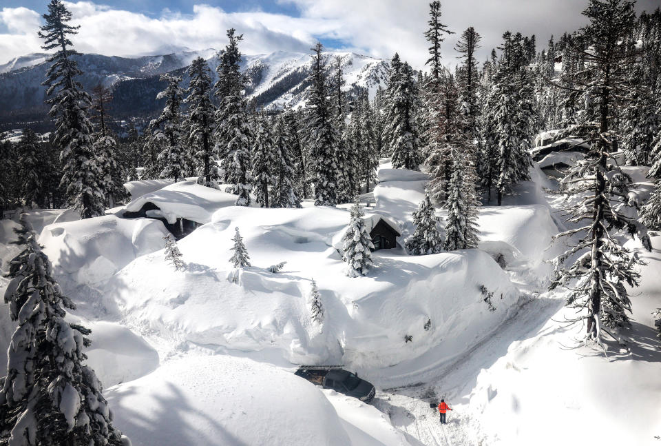
Heavy snow is also forecast for higher elevations of the Sierra Nevada, the agency said.
The UC Berkeley Central Sierra Snow Lab, a research institute based in Soda Springs, a census-designated place 89 miles northeast of Sacramento, tweeted Monday morning that the area had already seen 13.2 inches of snow in the last 24 hours and was expecting up to 30 more through Tuesday.
Rainfall amounts could reach 6 to 8 inches in parts of the Sierra Nevada and Southern California in the coming days. Snowfall amounts will be up to 4 feet above 7,000 feet and 8 feet above 9,000 feet.
"Considerable flooding impacts" are also expected below 5,000-foot elevation along the central California coast, San Joaquin Valley, Sacramento Valley and southern Sierra Nevada foothills into Tuesday, it said.
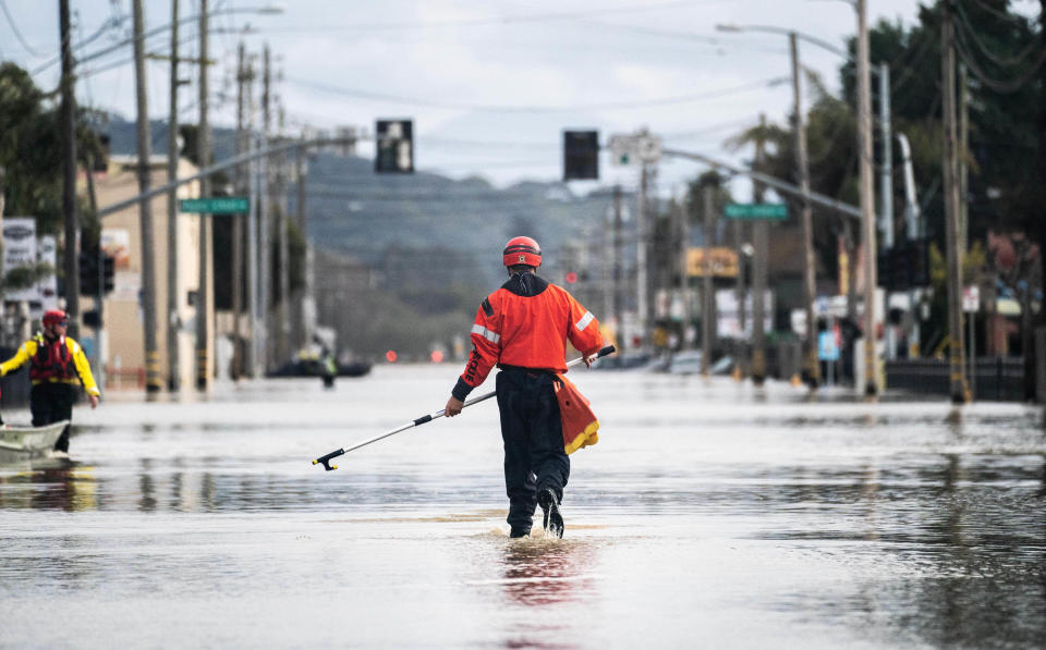
Areas most likely to see isolated flooding Monday include Eureka, Redding and Santa Rosa.
The weather service further warned that heavy rain and snowmelt could lead to renewed and more widespread flooding, particularly in low elevations.
"Some heavy snow can also be expected farther inland across the Intermountain West, especially central Idaho and western Wyoming," it said.
The latest round of severe weather follows major flooding and severe winds over the weekend.
The National Weather Service in Sacramento on Monday confirmed a tornado touched down in the area of Tuttletown, about 50 miles west of Yosemite National Park, Saturday. Forecasters said it was an EF-1 vortex, meaning it had sustained winds of at least 79 mph. It was accompanied by severe thunderstorms and hail, the weather service said.
More than 200 people in lowlands north of Salinas have been rescued by first responders, including members of the California National Guard, authorities said at a news conference Monday.
One video showed a member of the Guard helping a driver out of a car trapped by water.
Monterey County, a national agricultural center, was been hit hard by the weekend storm, with an estimated 2,000 residents of the town of Pajaro under evacuation orders after a 300 foot breach in an adjacent river levee started opening up early Saturday, officials sad.
A second, smaller breach near the mouth of the river took place was reported Monday, said Maia Carroll, spokesperson for Monterey County. Officials believe this one may be beneficial.
"The water is flowing to the ocean and relieving upstream flooding," she said.
Much of the town of Pajaro was soaked in 1 to 3 feet of standing water, County Supervisor Luis Alejo said in an interview Saturday. Some who didn't evacuate are now trapped and were being told to stay put, officials said.
Federal forecasters estimated the next storm, due overnight, could bring as much as 7 inches of rain to parts of Monterey County.
In an interview Saturday, Alejo lamented the plight of migrant farm workers who have been left without shelter and, in some cases, without jobs.
"These are immigrants, the people who can least afford being hit with this," he said. "They have homes, personal property. Many in agriculture will be out of jobs for a while because of the extensive damage from the storms."
By Sunday, California Gov. Gavin Newsom had declared weather-related emergencies in 40 of the state's 58 counties, with President Joe Biden vowing over the weekend to send federal resources to storm-battered areas under a federal emergency declaration Friday.
State meteorologist Michael Anderson had no good news during a video news conference Monday, saying, "We’re still moving water from the first event, while that second event comes to shore."
The incoming atmospheric river is stronger than the last, according to the Scripps Institution of Oceanography in San Diego, which rated its potency a 3 on a scale of 1 to 5 for Santa Cruz County, north of Pajaro. The weekend's storm was determined to have been a 1 on that scale, developed by Scripps' Center for Western Weather and Water Extremes.
Anderson piled on: As many as two more atmospheric rivers were on the horizon for March 19 to 22.
New England storm
Meanwhile, a clipper system moving east through the lower Great Lakes was expected to bring light to moderate snowfall across the Great Lakes before reaching New England.
"Farther south, a wavy front is forecast to bring some severe thunderstorms across the Southeast through tonight," the weather service said Monday.
"This wave is forecast to interact with the clipper system moving across the Great Lakes and intensify rapidly into a potent nor’easter off the New England coast on Tuesday, bringing heavy wet snow inland and high winds with rain/snow near the coast."
Download the NBC News app for your local weather and updates on the storm
Heavy snow rates of up to 2 inches per hour are possible, while strong winds from the nor’easter could make travel "dangerous to near impossible," the weather service warned. The severe weather conditions could also lead to outages and tree damage, it said.
Winds will also crank up, with wind gusts of 50 to 60 mph likely, especially right along the coast. This could result in blizzard conditions in some areas.
Higher elevation areas across the interior Northeast could see more than 12 inches of snow, it said. It further warned that some areas, including the Catskills in New York, the Berkshires in western Massachusetts and the southern Green Mountains in Vermont, could see localized higher snowfall amounts.
"Widespread minor coastal flooding may be possible Monday night through Wednesday as the low pressure deepens off the coast of New England with high winds most likely near Cape Cod later on Tuesday," the weather service said.
Massachusetts Gov. Maura Healey on Monday ordered most state employees under her purview not to report to work Tuesday in order to stay safe, stay off the roads, and avoid the possibility of needing rescue and medical attention from already burdened first responders.
Connecticut Gov. Ned Lamont activated the state's emergency operations center in anticipation of storm damage, transportation issues, and the possibility rescues or medical attention will result.
Prepping in New York
At a news conference Monday, New York Gov. Kathy Hochul said that the storm "could be deadly" and that it will bring "serious loss of power." She urged New Yorkers to spend Monday preparing for the storm and plan to stay home Tuesday.
"That’s the No. 1 message — there’s no reason in the world to have plans to be out tomorrow," she said.
New York will enter a state of emergency beginning at 8 p.m. Monday, Hochul said. The National Guard has been deployed throughout the state, she added.
The Albany area could see 1 to 2 inches of snow per hour, the National Weather Service of Albany said, with the governor’s office adding that could amount to up to 3 feet by Wednesday morning.
New York City and Long Island could see up to 2 inches of snow and are expected to see heavy winds and rain, and the state’s western and Finger Lakes regions could see 8 inches or more of snow by Wednesday, according to the governor’s office.
Power company PSEG Long Island said in a statement that it was preparing for potential outages that could be caused by high winds of up to 48 mph that could pull down wires. Con Edison, which serves New York City and Westchester, said Monday afternoon it is "securing extra crews and mobilizing for the winter storm."
New Jersey Gov. Phil Murphy on Monday declared a state of emergency in five counties — Bergen, Morris, Passaic, Sussex and Warren — ahead of the storm’s impacts.
On Wednesday, the system will move away from the coast, with morning snow lingering along coastal New England. Winds will stay strong all day in much of the Northeast.
This article was originally published on NBCNews.com

