Severe storms expected Thursday in North Texas. Freezing temperatures Friday to Saturday
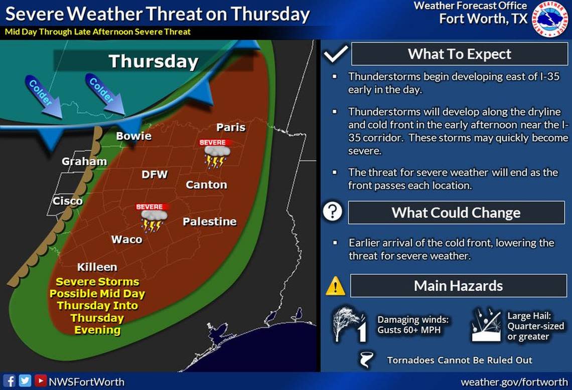
Potentially severe thunderstorms are forecast in North Texas on Thursday, according to the National Weather Service in Fort Worth.
Then a cold front is expected to led to freezing or near-freezing temperatures in the region on Friday night.
Thunderstorms will begin developing east of Interstate 35 early in the day Thursday. The threat will increase in the early afternoon near and east of I-35 as storms develop along the dryline and cold front coming from the north and could quickly become severe.
The affected areas and cities are likely to include Dallas-Fort Worth, Bowie, Graham, Cisco, Paris, Canton, Palestine, Waco and Killeen, according to the weather service.
Large, quarter-sized or bigger hail and damaging winds with gusts of 60 mph are the main expected hazards, according to the NWS. A few tornadoes and heavy rain with flooding will be possible.
Severe weather chances will end as the cold front passes through, the weather service said. The degree and timing of severe weather threats could change depending on when the cold front arrives.
Near-freezing temperatures are expected Friday into Saturday morning in the Fort Worth area.
It will be around 34 degrees in Fort Worth and 35 degrees in Dallas on Saturday morning.
Freeze “probabilities are highest across our west and northwest counties where temperatures will be coldest,” the NWS said.
The NWS urges residents to take precautions to protect sensitive plants and crops from freezing temperatures and to monitor the forecast throughout the week due to uncertainty.
3-Day Storm Outlook
This map shows the 3-day weather outlook for storms by the National Weather Service's Storm Prediction Center. Sources: National Weather Service, Esri.
Current Temperatures
Current temperatures and weather data from NOAA weather stations updated hourly. Tap on the map for current weather conditions, including humidity, wind speed. and direction. Data provided by NOAA and Esri.

