Tornado watch in effect as severe storms set to roll through central Pennsylvania
Update at 1:20 p.m.: A tornado watch has been issued for Adams, Franklin, Lebanon, and York counties until 9 p.m., the National Weather Service says.
Reported earlier:
Severe weather, possibly including large hail and an isolated tornado, is in the forecast for southcentral Pennsylvania today, according to the National Weather Service.
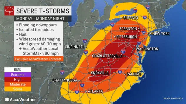
The weather service has issued the hazardous outlook for numerous counties, including Adams, Lebanon, Franklin and York.
Severe storms with winds of 60 mph or greater are expected this afternoon and evening. It could include hail an inch or thicker in diameter, the weather service says.
⚠️(1/2) Today will be an active day for weather across central PA as showers and thunderstorms are expected across the region today. The main threat will be damaging winds, although large hail, isolated tornadoes, and localized flash flooding cannot be ruled out. #PAwx pic.twitter.com/MxuVBC2mYe
— NWS State College (@NWSStateCollege) August 7, 2023
Severity, timing of the storms today
Damaging winds are the main threat with the storms expected later today, meteorologist Nicholas Beaty said. Localized flash flooding is possible in the late afternoon and early evening.
Hail and an isolated tornado cannot be ruled out with the storms.
The storms will arrive likely between 4 p.m. and 8 p.m., Beaty said.
A potent cold front moving in will be triggering the storms today. Daytime heating could make them ramp up quickly, Beaty said.
Southcentral Pennsylvania is at high risk for the severe storms, according to AccuWeather.com. It, too, is calling for high winds, flooding downpours, hail and possibly a tornado.
Chesapeake Bay: PA farmers 'don't get enough credit' for bay cleanup, says longtime York County farmer
Dry weather expected after storms
Fairly dry weather is expected after these storms move through the area, Beaty said.
The forecast calls for Tuesday to be partly sunny with a high near 81 and Wednesday to be sunny with a high near 88, the weather service says.
The next chance of rain − showers and thunderstorms − is Wednesday night into Thursday. However, those are not expected to be severe, Beaty said.
This article originally appeared on York Daily Record: Severe storms with a possible tornado to hit central Pennsylvania: NWS
