Severe storms with large hail, damaging winds possible Thursday in parts of North Texas
Parts of North Texas could see severe storms with damaging wind and large hail Thursday evening, according to the National Weather Service in Fort Worth.
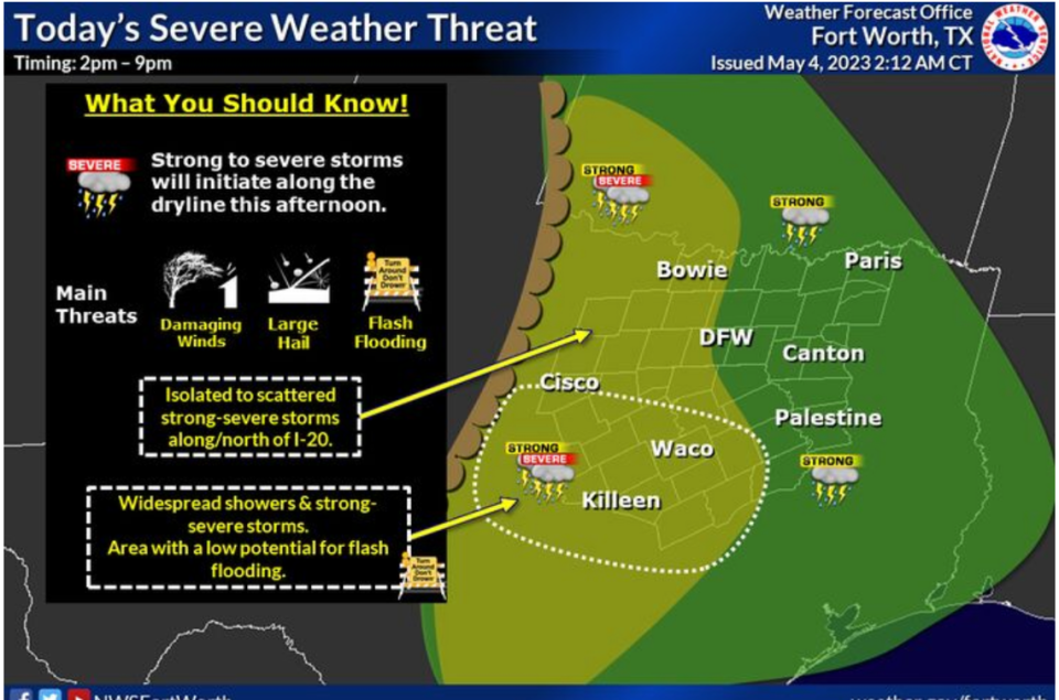
The greatest threat for severe weather is west of Dallas-Fort Worth, but it can’t be ruled out completely for the Metroplex either, according to NWS meteorologist Monique Sellers. Residents should remain weather alert throughout the afternoon and evening.
A severe thunderstorm watch is in effect for counties to the west of Tarrant until midnight, and a tornado watch was issued for some counties to the north until 9 p.m. Threats for any storms in the warned areas will include damaging winds up to 70 mph, large hail up to 2.5 inches in diameter (about tennis ball size,) and a tornado or two.
A Severe Thunderstorm Watch and Tornado Watch are in effect until 12 AM Friday and 9 PM Thursday, respectively. Threats will include damaging winds, large hail up to 2.5 inches in diameter, and a tornado or two. #ntxwx #ctxwx #txwx pic.twitter.com/GCM8rQL164
— NWS Fort Worth (@NWSFortWorth) May 4, 2023
Counties near DFW in the watch include Wise, Parker and Hood. Denton and Collin counties also have been added.
Storms were predicted to start forming west of Dallas-Fort Worth between noon and 3 p.m., Sellers said, and were forecast to possibly reach the Interstate 35 corridor starting between 4 and 7 p.m.
[MORE: 61 pools in Fort Worth cited for serious health or safety violations]
Some storms may be severe with damaging winds and large hail. The threat for tornadoes is low, according to Sellers, but always a possibility.
The weekend is expected to be warm and wet with another chance for severe storms Friday afternoon. Meteorologists aren’t sure where the storms will develop, so residents should keep an eye on the weather, Sellers said.
There is a 10% chance of showers and thunderstorms in the Dallas-Fort Worth area before 7 p.m. Friday, according to the National Weather Service. The forecast for Saturday is mostly sunny with a 20% chance for showers and thunderstorms after 1 p.m.
Sunday is expected to be partly sunny with a high around 89 and a 30% chance of showers and thunderstorms after 1 p.m.
Storm chances may continue each afternoon through Wednesday.
3-Day Storm Outlook
This map shows the 3-day weather outlook for storms by the National Weather Service's Storm Prediction Center. Sources: National Weather Service, Esri.
Current Temperatures
Current temperatures and weather data from NOAA weather stations updated hourly. Tap on the map for current weather conditions, including humidity, wind speed. and direction. Data provided by NOAA and Esri.

