Severe storms, possible tornadoes, cold front. It's all in Florida's weather forecast
Florida residents and visitors could see just about everything Mother Nature has in her weather arsenal over the next several days.
A system of low pressure moving toward Florida is expected to bring severe weather, including thunderstorms, strong winds, flooding rains, and the potential for tornadoes and waterspouts.
If that weren't enough, there's also a warm front that will be moving north, followed by a cold front expected to bring cooler temperatures, with several areas seeing low temperatures drop by more than 10 degrees by Monday.
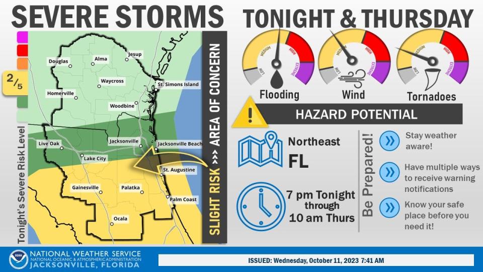
"The greatest risk for damaging winds and stray tornadoes today stretches from Apalachicola to Jacksonville and south to Fort Myers and Fort Pierce," according to the Florida Public Radio Emergency Network.
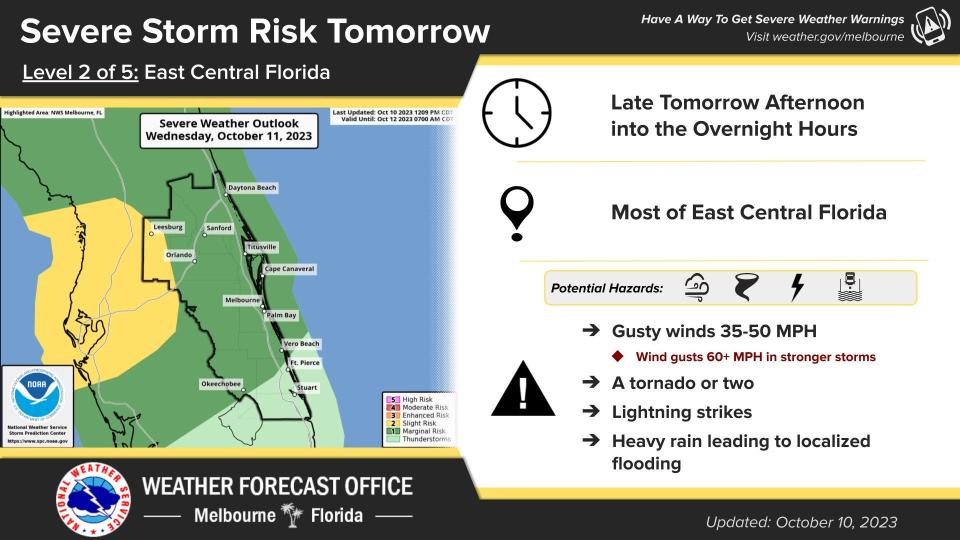
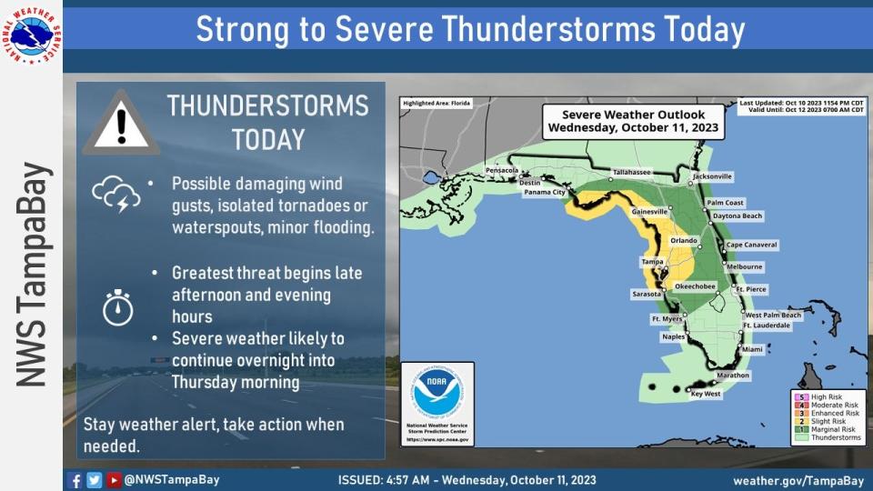
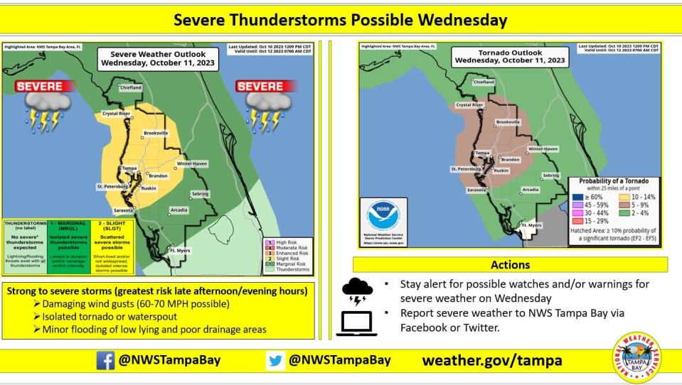
The main threats will be local flooding, damaging winds and isolated tornadoes Wednesday and Thursday.
Rain and wind will begin to increase across the Panhandle and parts of the Peninsula Wednesday morning. Heavy showers and storms will continue into early Thursday.
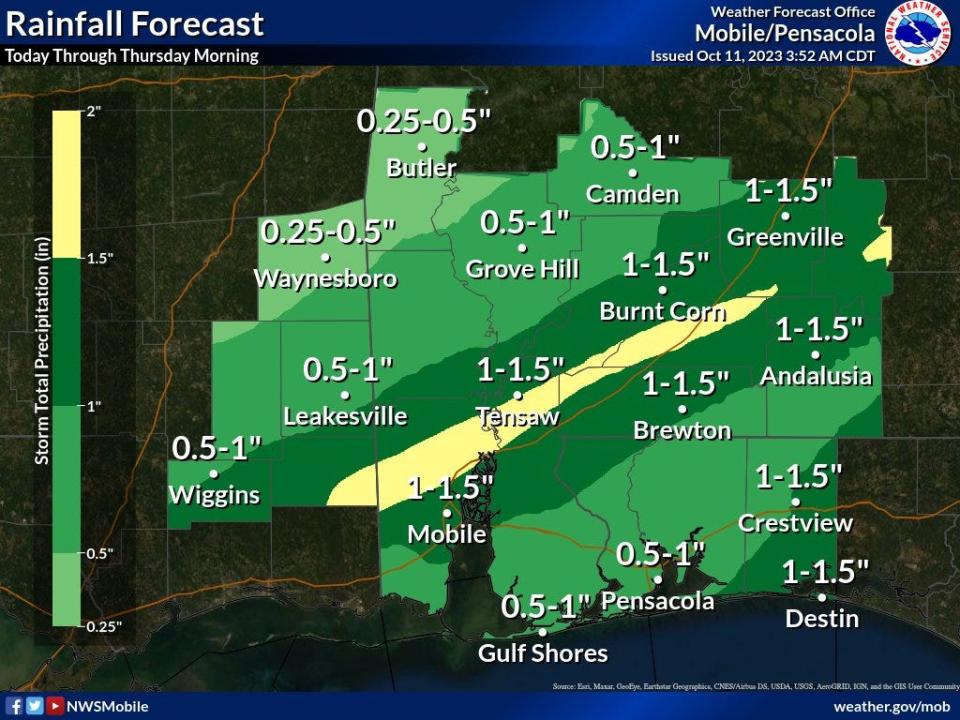
Most of the area could receive 1 to 4 inches of rain, with some locations seeing more than 5 inches. Local flooding will be the main concern but isolated tornadoes and damaging winds over 60 mph are possible in the strongest storms, according to the Florida Public Radio Emergency Network.
Weather alerts issued in Florida
Power outages across Florida
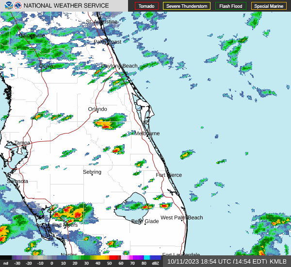
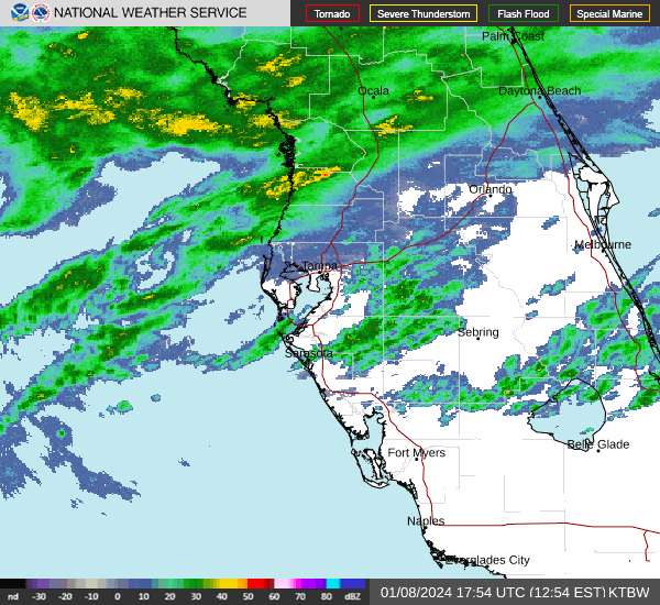
Weather radar for Pensacola

Follow National Weather Service Mobile on Twitter
Weather forecast for Pensacola
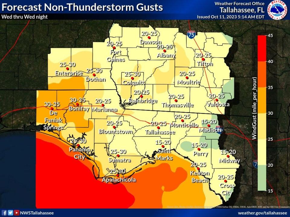
A wind advisory is in effect from 4 p.m. CT to 4 a.m. Thursday. Northeast winds of 15 to 25 mph with gusts up to 40 mph are expected.
A high surf advisory is in effect from 7 p.m. CT Wednesday to noon Thursday. Large breaking waves of 4 to 6 feet are expected in the surf zone.
A high rip current risk remains in effect from Wednesday evening through Saturday morning.
Wednesday: High: 76; low: 61. Rain: 90%
Thursday: High: 78; low 68. Rain 30%
Friday: High: 83; low 30%. Rain 40%
Saturday: High 85; low 58
Sunday: High 75; low 55
Monday: High: 71; low 50
Weather radar for Tallahassee

Follow the National Weather Service Tallahassee on Twitter
Weather forecast for Tallahassee
Gale warnings are in effect.
A wind advisory is in effect from coastal Walton to Franklin/Wakulla counties.
There's a high rip current risk at all local beaches.
Wednesday: High: 75; low 66. Rain 60-100%
Thursday: High: 74; low 68. Rain 60%
Friday: High: 83; low 70. Rain 50%
Saturday: High: 85; low 58
Sunday: High: 74; low 54
Monday: High: 70; low 49
2023 hurricane season forecast: No-name storm brings nasty weather to Florida; cold fronts could chill hurricane season
Weather radar for Jacksonville

Follow the National Weather Service Jacksonville on Twitter
Weather forecast for Jacksonville
A high rip current risk is in effect through late Wednesday.
Wednesday: High: 80; low 71. Rain 30-100%
Thursday: High: 78; low 72. Rain 90%
Friday: High: 84; low 73. Rain 60%
Saturday: High: 88; low 65. Rain 40%
Sunday: High: 78; low 57
Monday: High 73; low 54
Weather radar for Daytona Beach
Follow the National Weather Service Melbourne on Twitter
Weather forecast for Daytona Beach
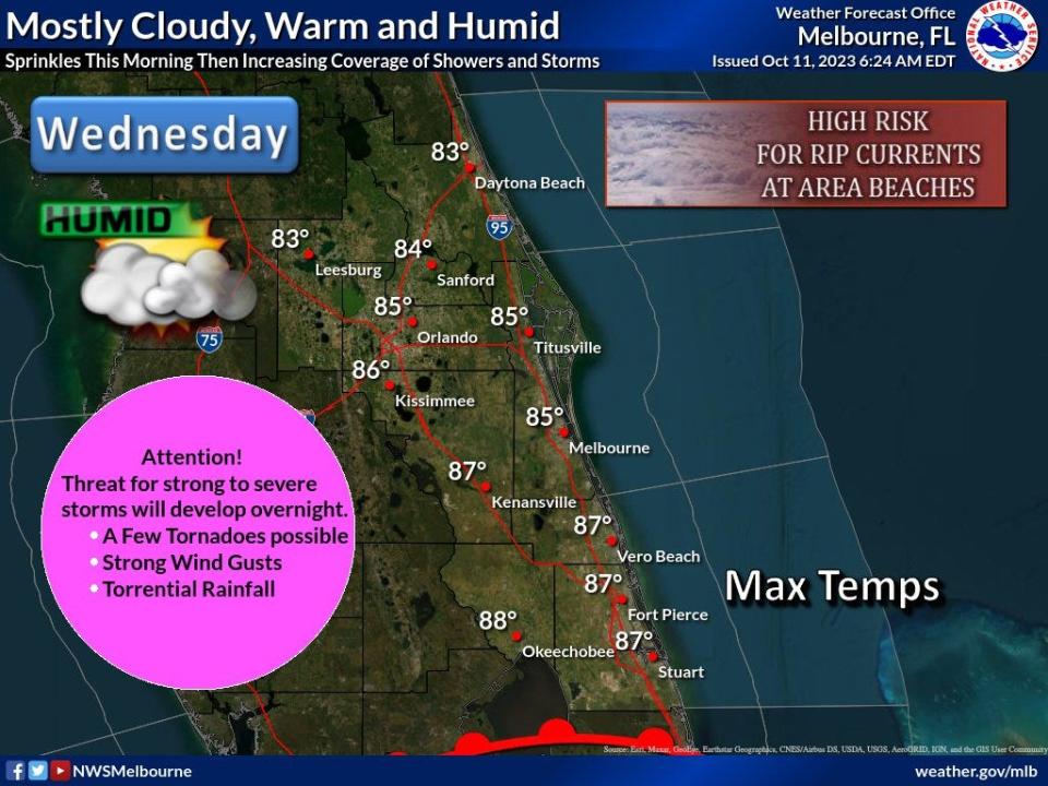
Lightning storms will increase throughout the day, with the highest chance for storm Wednesday evening and overnight. Wind gusts up to 50 mph possible, frequent lightning and heavy downpours. A few tornadoes also possible, especially in Lake County overnight.
Widespread rainfall amounts of 1.5 to 2.5 inches, with locally high rainfall amounts up to 5 inches possible.
Small craft advisories for winds 20 to 25 knots will go into effect for the offshore Atlantic waters tonight, starting at midnight in the Volusia and Brevard waters, then extending into the Treasure Coast waters at 3 a.m.
A flood warning continues for the St. Johns River near Astor, affecting Volusia and Lake counties.
A high rip current risk is in effect through late Wednesday.
Wednesday: High: 82; low 74. Rain 30-90%
Thursday: High 84; low 75; Rain 80%
Friday: High: 85; low 74. Rain 60%
Saturday: High: 86; low 70. Rain 50%
Sunday: High: 80; low 59
Monday: High: 74; low 56
Weather radar for Melbourne
Follow the National Weather Service Melbourne on Twitter
Weather forecast for Melbourne
Lightning storms will increase throughout the day, with the highest chance for storm Wednesday evening and overnight. Wind gusts up to 50 mph possible, frequent lightning and heavy downpours. A few tornadoes also possible.
Widespread rainfall amounts of 1.5 to 2.5 inches, with locally high rainfall amounts up to 5 inches possible.
Small craft advisories for winds 20 to 25 knots will go into effect for the offshore Atlantic waters tonight, starting at midnight in the Volusia and Brevard waters, then extending into the Treasure Coast waters at 3 a.m.
A high rip current risk is in effect through late Wednesday.
Wednesday: High: 85; low 77. Rain 60-80%
Thursday: High: 89; low 77. Rain 80%
Friday: High: 89; low 76. Rain 60%
Saturday: High: 89; low 75. Rain 50%
Sunday: High: 86; low 77
Monday: High: 77; low 61
Weather radar for Port St. Lucie
Follow the National Weather Service Melbourne on Twitter
Weather forecast for Port St. Lucie
Lightning storms will increase throughout the day, with the highest chance for storm Wednesday evening and overnight. Wind gusts up to 50 mph possible, frequent lightning and heavy downpours. A few tornadoes also possible.
Widespread rainfall amounts of 1.5 to 2.5 inches, with locally high rainfall amounts up to 5 inches possible.
Small craft advisories for winds 20 to 25 knots will go into effect for the offshore Atlantic waters tonight, starting at midnight in the Volusia and Brevard waters, then extending into the Treasure Coast waters at 3 a.m.
A high rip current risk is in effect through late Wednesday.
Wednesday: High: 88; low 77. Rain 60%
Thursday: High: 90; low 76. Rain 70%
Friday: High: 91; low 74. Rain 60%
Saturday: High: 91; low 75. Rain 50%
Sunday: High: 88; low 67. Rain 30%
Monday: High: 78; low 58
Weather radar for West Palm Beach
Follow the National Weather Service Miami on Twitter
Weather forecast for West Palm Beach
A high rip current risk is in effect through late Wednesday night.
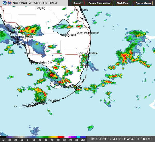
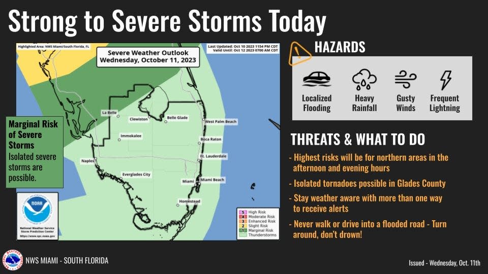
Scattered to numerous showers and thunderstorms will develop early this afternoon. A few may be strong to severe, especially near the Lake Okeechobee region and Southwest Florida.
Chances of thunderstorms will continue each afternoon and evening through the remainder of the work-week. Primary hazards will be strong wind gusts, frequent lightning and localized flooding around areas that receive repeat rounds of rainfall.
High temperatures will be slowly increasing through this week with possible record highs in the mid 90s for the second half of the week. Heat indices could hit 105 to 110 degrees for the second half of this week.
Wednesday: High: 85; low 81. Rain 80%
Thursday: High: 88; low 80. Rain 60%
Friday: High: 89; low 79. Rain 60%
Saturday: High: 89; low 79. Rain 40%
Sunday: High 87; low 69. Rain 40%
Monday: High: 77; low 66.
Weather radar for Naples
Follow the National Weather Service Miami on Twitter
Weather forecast for Naples
10/10 at 8:30pm: Aside from high-level clouds, the weather will remain quiet during the overnight hours.
As the boundary lifts northward across South Florida tomorrow, scattered showers and storms will be possible across our area tomorrow afternoon. pic.twitter.com/ph9oRBhRkC— NWS Miami (@NWSMiami) October 11, 2023
A high rip current risk is in effect through late Wednesday night.
Scattered to numerous showers and thunderstorms will develop early this afternoon. A few may be strong to severe, especially near the Lake Okeechobee region and Southwest Florida.
Chances of thunderstorms will continue each afternoon and evening through the remainder of the work-week. Primary hazards will be strong wind gusts, frequent lightning and localized flooding around areas that receive repeat rounds of rainfall.
High temperatures will be slowly increasing through this week with possible record highs in the mid 90s for the second half of the week. Heat indices could hit 105 to 110 degrees for the second half of this week.
Wednesday: High: 90; low 80. Rain 70%
Thursday: High: 90; low 70. Rain 50%
Friday: High: 90; low 78. Rain 30%
Saturday: High: 89; low 78. Rain 20%
Sunday: High: 87; low 68. Rain 20%
Monday: High 80; low 64.
Weather radar for Fort Myers
Follow the National Weather Service Tampa Bay on Twitter
Weather forecast for Fort Myers
Possible damaging wind gusts, isolated tornadoes and minor flooding in the forecast. The greatest threat will be from late Wednesday afternoon and into the evening.
Severe weather is likely to continue overnight and into Thursday morning.
Wednesday: High: 90; low 79. Rain 50%
Thursday: High 88; low 80. Rain 70%
Friday: High: 89; low 77. Rain 40%
Saturday: High: 89; low 78. Rain 30%
Sunday: High: 86; low 66. Rain 20%
Monday: High: 78; low 61
Weather radar for Sarasota
Follow the National Weather Service Tampa Bay on Twitter
Weather forecast for Sarasota
Possible damaging wind gusts, isolated tornadoes and minor flooding in the forecast. The greatest threat will be from late Wednesday afternoon and into the evening.
Severe weather is likely to continue overnight and into Thursday morning.
Wednesday: High: 90; low 78. Rain 40-80%
Thursday: High: 89; low 79. Rain 70%
Friday: High: 89; low 78. Rain 40%
Saturday: High: 89; low 76. Rain 40%
Sunday: High: 84; low 67.
Monday: High: 78; low 62.
This article originally appeared on Treasure Coast Newspapers: Florida weather forecast, radar. Thunderstorms, tornadoes, cold front

